
A USGS Cascades Volcano Observatory field team waits on this remote north flank of Mount Hood, as a helicopter delivers supplies and equipment to station BRSP. The station was installed with minimal impact on the environment. A helicopter delivered equipment via external sling load and USGS personnel accessed the site by foot.
Images
Volcano Hazard Program images.
Filter Total Items: 6230

Helicopter delivers equipment to station BRSP on Mount Hood
A USGS Cascades Volcano Observatory field team waits on this remote north flank of Mount Hood, as a helicopter delivers supplies and equipment to station BRSP. The station was installed with minimal impact on the environment. A helicopter delivered equipment via external sling load and USGS personnel accessed the site by foot.

Panoramic view of Pocket Basin, Yellowstone National Park
Panoramic photo of Pocket Basin, a hydrothermal explosion crater in Yellowstone National Park's Lower Geyser Basin, taken from the northeast rim looking southwest into the crater. Pocket Basin is a U-shaped crater that is dissected on the SW edge by the Firehole River, visible on the far-right of the photo.
Panoramic photo of Pocket Basin, a hydrothermal explosion crater in Yellowstone National Park's Lower Geyser Basin, taken from the northeast rim looking southwest into the crater. Pocket Basin is a U-shaped crater that is dissected on the SW edge by the Firehole River, visible on the far-right of the photo.
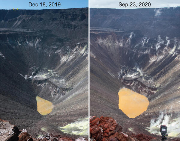
Kīlauea's summit water lake comparison - September 23, 2020
HVO geologists made observations of Kīlauea's summit water lake from the east rim of Halema‘uma‘u. This view point is on the large downdropped block that subsided during the 2018 collapse events. From this spot, a view of the entire lake is possible, providing a new perspective on the growth of the lake.
HVO geologists made observations of Kīlauea's summit water lake from the east rim of Halema‘uma‘u. This view point is on the large downdropped block that subsided during the 2018 collapse events. From this spot, a view of the entire lake is possible, providing a new perspective on the growth of the lake.

Kīlauea's water lake from the east side - September 23, 2020
This view shows Kīlauea's water lake from the east side of the crater. On September 23, 2020, the western portion of the lake (top of image) was the most varied in color, with patches of greenish and brown water. The majority of the lake surface, however, was the typical tan hue. USGS photo by M. Patrick.
This view shows Kīlauea's water lake from the east side of the crater. On September 23, 2020, the western portion of the lake (top of image) was the most varied in color, with patches of greenish and brown water. The majority of the lake surface, however, was the typical tan hue. USGS photo by M. Patrick.

Floating material on Kīlauea's summit water lake on September 23, 2020
Small patches of light-colored floating material were seen drifting on the surface of Kīlauea's summit water lake on September 23, 2020. The composition of this material is unknown, but future water sampling missions may provide insight. USGS photo by M. Patrick.
Small patches of light-colored floating material were seen drifting on the surface of Kīlauea's summit water lake on September 23, 2020. The composition of this material is unknown, but future water sampling missions may provide insight. USGS photo by M. Patrick.

Kīlauea’s summit water lake and Crater Rim Drive - September 23, 2020
Portions of Crater Rim Drive, within Hawai‘i Volcanoes National Park, appear cracked, offset, and down-dropped in this photo, taken during an overflight of Kīlauea’s summit on September 23, 2020. To the north, Kīlauea’s summit water lake, within Halema‘uma‘u, is visible. USGS photo by K. Mulliken.
Portions of Crater Rim Drive, within Hawai‘i Volcanoes National Park, appear cracked, offset, and down-dropped in this photo, taken during an overflight of Kīlauea’s summit on September 23, 2020. To the north, Kīlauea’s summit water lake, within Halema‘uma‘u, is visible. USGS photo by K. Mulliken.

Sulphur Banks area and Ha‘akulamanu trail
Hawaiian Volcano Observatory geologists flew over the Sulphur Banks area and Ha‘akulamanu trail within Hawai‘i Volcanoes National Park on September 23, 2020. Fumaroles in the Sulphur Banks area are sampled approximately every three months by Hawaiian Volcano Observatory gas geochemists to track long-term changes in volcanic gas chemistry at Kīlauea.
Hawaiian Volcano Observatory geologists flew over the Sulphur Banks area and Ha‘akulamanu trail within Hawai‘i Volcanoes National Park on September 23, 2020. Fumaroles in the Sulphur Banks area are sampled approximately every three months by Hawaiian Volcano Observatory gas geochemists to track long-term changes in volcanic gas chemistry at Kīlauea.

Wahinekapu (Steaming Bluff) and the Steam Vents area
The weather was overcast during an overflight of Kīlauea's summit on September 23, 2020. This view shows Wahinekapu (Steaming Bluff) and the Steam Vents area within Hawai‘i Volcanoes National Park. Extensive cracks in the area allow heated groundwater to escape from underground.
The weather was overcast during an overflight of Kīlauea's summit on September 23, 2020. This view shows Wahinekapu (Steaming Bluff) and the Steam Vents area within Hawai‘i Volcanoes National Park. Extensive cracks in the area allow heated groundwater to escape from underground.

Kīlauea summit gravity survey - September 23, 2020
On September 23, 2020, Hawaiian Volcano Observatory geophysicists and a geologist conducted a gravity survey of Kīlauea summit, as part of HVO's regular monitoring program. In this photo, scientists are carrying survey equipment westward along the remnants of the Halema‘uma‘u Trail on the down-dropped block of Kīlauea caldera.
On September 23, 2020, Hawaiian Volcano Observatory geophysicists and a geologist conducted a gravity survey of Kīlauea summit, as part of HVO's regular monitoring program. In this photo, scientists are carrying survey equipment westward along the remnants of the Halema‘uma‘u Trail on the down-dropped block of Kīlauea caldera.

Kīlauea summit gravity survey - September 23, 2020
During a gravity survey, HVO scientists measure the relative strength of gravity (gravimeter, bottom left corner of photo) between benchmarks. High-precision vertical positions from kinematic Global Positioning System (GPS, tripod and antenna middle of photo) help correct the gravity measurement for the effects of elevation changes.
During a gravity survey, HVO scientists measure the relative strength of gravity (gravimeter, bottom left corner of photo) between benchmarks. High-precision vertical positions from kinematic Global Positioning System (GPS, tripod and antenna middle of photo) help correct the gravity measurement for the effects of elevation changes.

Kīlauea summit gravity survey - September 23, 2020
A gravimeter makes a measurement at a benchmark situated among lava flows erupted in 1919. The strength of gravity varies with both elevation and the amount of mass beneath the instrument. Changes in mass can indicate changes in the amount of magma entering Kīlauea's magma reservoirs. USGS photo by A. Flinders.
A gravimeter makes a measurement at a benchmark situated among lava flows erupted in 1919. The strength of gravity varies with both elevation and the amount of mass beneath the instrument. Changes in mass can indicate changes in the amount of magma entering Kīlauea's magma reservoirs. USGS photo by A. Flinders.

Kīlauea summit gravity survey - September 23, 2020
An HVO geophysicist takes a gravity measurement at a benchmark near a continuous gravimeter (inside hutch). The continuous gravimeter takes gravity measurements once per second and relays the data via radio back to HVO. During the gravity survey on September 23, 2020, HVO scientists took measurements at multiple locations on the floor of Kīlauea caldera.
An HVO geophysicist takes a gravity measurement at a benchmark near a continuous gravimeter (inside hutch). The continuous gravimeter takes gravity measurements once per second and relays the data via radio back to HVO. During the gravity survey on September 23, 2020, HVO scientists took measurements at multiple locations on the floor of Kīlauea caldera.

Color variations at Kīlauea's summit water lake - 09/18/2020
Color variations are common at Kīlauea's summit water lake, and are usually dominated by tan and brown hues. Today, the interaction between different color zones produced a large swirl in the center of the lake.
Color variations are common at Kīlauea's summit water lake, and are usually dominated by tan and brown hues. Today, the interaction between different color zones produced a large swirl in the center of the lake.

Map of the USGS Hawaiian Volcano Observatory’s current camera network
Map of the USGS Hawaiian Volcano Observatory’s current camera network coverage. Lava-flow hazard zone 1 is outlined in yellow. Color-shaded areas are visible to at least one camera in the current network. We would like to expand the network so that it covers the grey-shaded areas in zone 1 as well. If your property has a good view
Map of the USGS Hawaiian Volcano Observatory’s current camera network coverage. Lava-flow hazard zone 1 is outlined in yellow. Color-shaded areas are visible to at least one camera in the current network. We would like to expand the network so that it covers the grey-shaded areas in zone 1 as well. If your property has a good view

The inside of a Yellowstone borehole seismometer equipment enclosure
The inside of a borehole seismometer equipment enclosure is full of batteries, cables, data communications equipment and data recording instruments. Some of the geodetic infrastructure in Yellowstone National Park is colocated with seismic equipment. In this case, the communications downlink radio for the GNSS station is housed with the borehole enc
The inside of a borehole seismometer equipment enclosure is full of batteries, cables, data communications equipment and data recording instruments. Some of the geodetic infrastructure in Yellowstone National Park is colocated with seismic equipment. In this case, the communications downlink radio for the GNSS station is housed with the borehole enc

GNSS site LKWY, on the north side of Yellowstone Lake
GNSS site LKWY, which was visited in September 2020 to install new GNSS equipment and upgrade the communications for improved data quality. The site is now capable of collecting several times more observation data then was possible with the original older equipment.
GNSS site LKWY, which was visited in September 2020 to install new GNSS equipment and upgrade the communications for improved data quality. The site is now capable of collecting several times more observation data then was possible with the original older equipment.

View of Absaroka Range from Eagle Peak, WY, toward the southwest
View of Absaroka Range from Eagle Peak, WY, toward the southwest.
View of Absaroka Range from Eagle Peak, WY, toward the southwest.

On the surface of Kīlauea's new landscape, a story is told
On the surface of Kīlauea's new landscape, a story is told
On the surface of Kīlauea's new landscape, a story is told

Upper Geyser Basin viewed from the Old Faithful webcam
The Upper Geyser Basin viewed from the Old Faithful webcam. Hot water was piped from Solitary Geyser to the former site of the geyser bathhouse.
The Upper Geyser Basin viewed from the Old Faithful webcam. Hot water was piped from Solitary Geyser to the former site of the geyser bathhouse.

Map of thermal areas and lakes in Yellowstone National Park
Map of thermal areas in Yellowstone (red), as well as lakes (outlined in blue), many of which have thermal areas on their shores or beneath their surfaces.
Map of thermal areas in Yellowstone (red), as well as lakes (outlined in blue), many of which have thermal areas on their shores or beneath their surfaces.

Fern Lake, Yellowstone National Park, in different seasons
High-resolution images of Fern Lake from different seasons. North is up. Fern Lake is about 1 km across from east to west. Red arrows in the winter image point to large zones of open water, indicating either nearshore springs or underwater hydrothermal vents, but there are also many smaller zones of open water that are conspicuous.
High-resolution images of Fern Lake from different seasons. North is up. Fern Lake is about 1 km across from east to west. Red arrows in the winter image point to large zones of open water, indicating either nearshore springs or underwater hydrothermal vents, but there are also many smaller zones of open water that are conspicuous.