
USGS scientist Laura Clor performing maintenance on the SNIF multi-GAS station on Mount St. Helens, Washington.
Images
Volcano Hazard Program images.
Filter Total Items: 6230

SNIF multi-GAS station on Mount St. Helens, Washington
USGS scientist Laura Clor performing maintenance on the SNIF multi-GAS station on Mount St. Helens, Washington.

interior of SNIF multi-GAS enclosure on Mount St. Helens, Washington
Interior of the SNIF multi-GAS enclosure on Mount St. Helens, Washington
Interior of the SNIF multi-GAS enclosure on Mount St. Helens, Washington

Rainbow over Halema‘uma‘u and the water lake
The KWcam webcam at Kīlauea's summit captured a rainbow over the water lake in Halema‘uma‘u this afternoon, as light mist moved across the caldera.
The KWcam webcam at Kīlauea's summit captured a rainbow over the water lake in Halema‘uma‘u this afternoon, as light mist moved across the caldera.

A MultiGAS instrument measures gases at Newberry Volcano
Scientists use a MultiGAS instrument (gray, hard-shell case) to measure gas compositions from the East Lake hot spring in the Newberry caldera. The photo was taken on August 3, 2020 just after sunrise. The vapor above the hot spring and lake is typical for cool mornings and is not visible later in the day.
Scientists use a MultiGAS instrument (gray, hard-shell case) to measure gas compositions from the East Lake hot spring in the Newberry caldera. The photo was taken on August 3, 2020 just after sunrise. The vapor above the hot spring and lake is typical for cool mornings and is not visible later in the day.

Timelapse showing typical activity at Kīlauea's summit water lake
This timelapse video at Kīlauea's summit covers approximately 30 minutes and shows the dynamic nature of the water lake in Halema‘uma‘u crater. Steam from the hot water surface is constantly shifting in the winds, while the migrating color boundaries on the water surface appear to show circulation in the lake. USGS video by M. Patrick.
This timelapse video at Kīlauea's summit covers approximately 30 minutes and shows the dynamic nature of the water lake in Halema‘uma‘u crater. Steam from the hot water surface is constantly shifting in the winds, while the migrating color boundaries on the water surface appear to show circulation in the lake. USGS video by M. Patrick.
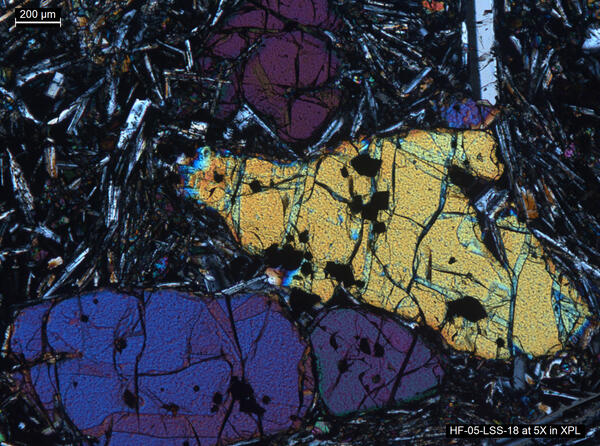
Thin section image of a lava sample from Yellowstone
Thin section image of a lava sample from Yellowstone using a polarizing microscope. The mineral assemblage is representative of many of Yellowstone’s basaltic rocks. The three large and colored crystals (known as phenocrysts) in the center of the image are the mineral olivine.
Thin section image of a lava sample from Yellowstone using a polarizing microscope. The mineral assemblage is representative of many of Yellowstone’s basaltic rocks. The three large and colored crystals (known as phenocrysts) in the center of the image are the mineral olivine.

Kīlauea Volcano's summit water lake is one-year old
Plot showing rise of Kīlauea's summit crater lake over the past year, during which laser rangefinder measurements of lake level were made 2–3 times per week. Photos compare the lake on August 27, 2019, when it was ~22 ft (7 m) deep, to July 7, 2020, when it was ~130 ft (40 m) deep. USGS photos.
Plot showing rise of Kīlauea's summit crater lake over the past year, during which laser rangefinder measurements of lake level were made 2–3 times per week. Photos compare the lake on August 27, 2019, when it was ~22 ft (7 m) deep, to July 7, 2020, when it was ~130 ft (40 m) deep. USGS photos.

Continued slow rise of water in Halema‘uma‘u
Kīlauea's summit water lake, in Halema‘uma‘u, continues to slowly rise. Today, the lake colors were vibrant, with a zone of aquamarine water in the west end (lower right in photo). These greenish zones tend to be slightly hotter, and appear to be zones of water influx. USGS photo by M. Patrick.
Kīlauea's summit water lake, in Halema‘uma‘u, continues to slowly rise. Today, the lake colors were vibrant, with a zone of aquamarine water in the west end (lower right in photo). These greenish zones tend to be slightly hotter, and appear to be zones of water influx. USGS photo by M. Patrick.

Kīlauea crater lake one year anniversary
ANIMATED GIF: Saturday, July 25, marks the one year anniversary since water was first spotted at the bottom of Halema‘uma‘u, at the summit of Kīlauea. Over the past year, the summit water lake has grown to more than 270 m (885 ft) long and 131 m (430 ft) wide, with a surface area over 2.5 hectares (6 acres).
ANIMATED GIF: Saturday, July 25, marks the one year anniversary since water was first spotted at the bottom of Halema‘uma‘u, at the summit of Kīlauea. Over the past year, the summit water lake has grown to more than 270 m (885 ft) long and 131 m (430 ft) wide, with a surface area over 2.5 hectares (6 acres).

Comparison of images showing growth of Kīlauea's summit water lake
Comparison of images showing growth of Kīlauea's summit water lake over the past year. The left image, taken on August 2, 2019, shows a small green pond that was approximately 6 ft (2 m) deep. The right image, taken on July 21, 2020, shows a lake more than 130 ft (40 m) deep with shades of tan to brown and a sharp color boundary often cutting across the lake.
Comparison of images showing growth of Kīlauea's summit water lake over the past year. The left image, taken on August 2, 2019, shows a small green pond that was approximately 6 ft (2 m) deep. The right image, taken on July 21, 2020, shows a lake more than 130 ft (40 m) deep with shades of tan to brown and a sharp color boundary often cutting across the lake.

Kīlauea summit crater lake growth July 25, 2019 to July 25, 2020
Kīlauea
Summit crater lake growth
July 25, 2019 to July 25, 2020
Kīlauea
Summit crater lake growth
July 25, 2019 to July 25, 2020

Using a rangefinder to determine the height of Steamboat Geyser
In the first few minutes of Steamboat's eruptions, it has often been measured well over 300 ft. with a few exceptional eruptions measured by visitors at over 400 ft.! In this example, done using a rangefinder by a Yellowstone National Park ranger, it comes in at 334.9 ft. For comparison, the Lower Falls of the Yellowstone is about 308 ft.
In the first few minutes of Steamboat's eruptions, it has often been measured well over 300 ft. with a few exceptional eruptions measured by visitors at over 400 ft.! In this example, done using a rangefinder by a Yellowstone National Park ranger, it comes in at 334.9 ft. For comparison, the Lower Falls of the Yellowstone is about 308 ft.

The Raspberry Shake 4D (RS4D)
The Raspberry Shake 4D (RS4D) is a personal seismograph with a vertical-component velocity transducer, and three-component (vertical, north-south, and east-west) accelerometer. A Raspberry Pi, which is a computer about the size of a credit card, powers the RS4D unit, which is about the size of a can of Spam.
The Raspberry Shake 4D (RS4D) is a personal seismograph with a vertical-component velocity transducer, and three-component (vertical, north-south, and east-west) accelerometer. A Raspberry Pi, which is a computer about the size of a credit card, powers the RS4D unit, which is about the size of a can of Spam.

August 2019 to July 2020 summit lake comparison
Image comparison of Kīlauea summit lake on August 2, 2019 and July July 21, 2020
Image comparison of Kīlauea summit lake on August 2, 2019 and July July 21, 2020

NPS scientist collects imagery of Castle Geyser, Yellowstone
National Park Service scientist using a camera paired with a GPS receiver to obtain images of Castle Geyser, Yellowstone National Park, in June 2019.
National Park Service scientist using a camera paired with a GPS receiver to obtain images of Castle Geyser, Yellowstone National Park, in June 2019.

Comet NEOWISE and the Roosevelt Arch at Yellowstone National Park
Comet NEOWISE is seen with the Roosevelt Arch in the foreground at the north Entrance of Yellowstone National Park. The town of Gardiner, Montana, is in the background.
Comet NEOWISE is seen with the Roosevelt Arch in the foreground at the north Entrance of Yellowstone National Park. The town of Gardiner, Montana, is in the background.

No significant changes at Kīlauea's summit water lake
An HVO geologist collects GPS data on the western rim of Kīlauea's summit caldera. The geologist is standing upon a thick sequence of tephra deposits formed during explosive eruptions at Kīlauea's summit between about 1500 CE and the early 19th century.
An HVO geologist collects GPS data on the western rim of Kīlauea's summit caldera. The geologist is standing upon a thick sequence of tephra deposits formed during explosive eruptions at Kīlauea's summit between about 1500 CE and the early 19th century.

Violet Creek in Hayden Valley, Yellowstone National Park
A small stream, Violet Creek, winds its way through Hayden Valley in Yellowstone National Park.
A small stream, Violet Creek, winds its way through Hayden Valley in Yellowstone National Park.

Panorama of Hayden Valley, Yellowstone National Park
Panoramic photo of Hayden Valley looking east toward the Yellowstone River from the Mary Mountain trail.
Panoramic photo of Hayden Valley looking east toward the Yellowstone River from the Mary Mountain trail.

150 year Comparison of Giant and Castle Geysers, Yellowstone
Comparison of photos from Giant and Castle Geysers separated by almost 150 years. These images suggest almost no changes to the geyser structure implying that large geysers form over thousands of years.
Comparison of photos from Giant and Castle Geysers separated by almost 150 years. These images suggest almost no changes to the geyser structure implying that large geysers form over thousands of years.

Another view of the Fissure 8 channel, looking upstream. On the right, a lower
Another view of the Fissure 8 channel, looking upstream. On the right, a lower ledge along the channel wall represents the level of lava in the channel during the later stages of the flow. USGS photo by M. Patrick.
Another view of the Fissure 8 channel, looking upstream. On the right, a lower ledge along the channel wall represents the level of lava in the channel during the later stages of the flow. USGS photo by M. Patrick.