
Lower Yellowstone Falls and the trail to Red Rock Point as seen from Lookout Point. Photo by Neal Herbert, Yellowstone National Park. Available from https://www.flickr.com/photos/yellowstonenps/21136673039/.
Images
Volcano Hazard Program images.
Filter Total Items: 6230

Lower Yellowstone Falls
Lower Yellowstone Falls and the trail to Red Rock Point as seen from Lookout Point. Photo by Neal Herbert, Yellowstone National Park. Available from https://www.flickr.com/photos/yellowstonenps/21136673039/.

Kīlauea lower East Rift Zone
Early this morning, the Unmanned Aircraft Systems team was able to conduct a brief overflight of fissure 8 between passing rain showers, which resulted in abundant steaming on the flow field.
Early this morning, the Unmanned Aircraft Systems team was able to conduct a brief overflight of fissure 8 between passing rain showers, which resulted in abundant steaming on the flow field.

Kīlauea Volcano's lower East Rift Zone
A black sand beach blocks the boat ramp at Isaac Hale Beach Park. The beach consists of fragmented lava rock that is slowly migrating west at Pohoiki Bay.
A black sand beach blocks the boat ramp at Isaac Hale Beach Park. The beach consists of fragmented lava rock that is slowly migrating west at Pohoiki Bay.

Kīlauea lower East Rift Zone
An Unmanned Aircraft Systems overflight of fissure 8 on Saturday afternoon (Sept. 1, 2018) showed incandescence within the cinder cone, with reports that lava had covered the 65x15 m (210x45 ft) crater floor by evening.
An Unmanned Aircraft Systems overflight of fissure 8 on Saturday afternoon (Sept. 1, 2018) showed incandescence within the cinder cone, with reports that lava had covered the 65x15 m (210x45 ft) crater floor by evening.

Kīlauea lower East Rift Zone
An Unmanned Aircraft Systems overflight on Sunday afternoon (Sept. 2, 2018) showed that lava remained active within the fissure 8 cone.
An Unmanned Aircraft Systems overflight on Sunday afternoon (Sept. 2, 2018) showed that lava remained active within the fissure 8 cone.

This UAS oblique image of fissure 8 shows that the new lava is mostly confined t
This UAS oblique image of fissure 8 shows that the new lava is mostly confined to the crater floor within the cone, although a small amount extended a short distance into the spillway. HVO geologists noted that the lava activity was at a low level, with the area of incandescence decreasing to almost zero over the course of the afternoon.
This UAS oblique image of fissure 8 shows that the new lava is mostly confined to the crater floor within the cone, although a small amount extended a short distance into the spillway. HVO geologists noted that the lava activity was at a low level, with the area of incandescence decreasing to almost zero over the course of the afternoon.

Southeast arm of Yellowstone Lake
Southeast arm of Yellowstone Lake. Photo by Neal Herbert, Yellowstone National Park. Photo source: https://www.flickr.com/photos/yellowstonenps/15005709247/
Southeast arm of Yellowstone Lake. Photo by Neal Herbert, Yellowstone National Park. Photo source: https://www.flickr.com/photos/yellowstonenps/15005709247/

Geologic field-trip guide of volcaniclastic sediments from snow- and ice-capped
Geologic field-trip guide of volcaniclastic sediments from snow- and ice-capped volcanoes—Mount St. Helens, Washington, and Mount Hood, Oregon: U.S. Geological Survey Scientific Investigations Report 2017–5022–F, 97 p., https://doi.org/10.3133/sir20175022F.
Geologic field-trip guide of volcaniclastic sediments from snow- and ice-capped volcanoes—Mount St. Helens, Washington, and Mount Hood, Oregon: U.S. Geological Survey Scientific Investigations Report 2017–5022–F, 97 p., https://doi.org/10.3133/sir20175022F.

Another aerial view of the summit crater from this morning's overflight
Another aerial view of the summit crater from this morning's overflight. Zoom in to see HVO and the Park's Jaggar Museum on the caldera rim (right side of photo).
Another aerial view of the summit crater from this morning's overflight. Zoom in to see HVO and the Park's Jaggar Museum on the caldera rim (right side of photo).

Kīlauea summit caldera
This view across the summit caldera shows ground cracks (center) just north of Halema‘uma‘u. Rockfalls within the crater and along the caldera walls continue to stir up dust that can be seen here rising above the caldera rim.
This view across the summit caldera shows ground cracks (center) just north of Halema‘uma‘u. Rockfalls within the crater and along the caldera walls continue to stir up dust that can be seen here rising above the caldera rim.

Kīlauea Volcano's lower East Rift Zone
An Unmanned Aircraft Systems overflight of fissure 8 on August 21, 2018, showed no incandescence within the cinder cone. Minor amounts of gases, primarily steam, rose from the north wall of the cinder cone and from areas along the lower East Rift Zone. The interior walls of the fissure 8 cone and lava channel are slumping downward and inward.
An Unmanned Aircraft Systems overflight of fissure 8 on August 21, 2018, showed no incandescence within the cinder cone. Minor amounts of gases, primarily steam, rose from the north wall of the cinder cone and from areas along the lower East Rift Zone. The interior walls of the fissure 8 cone and lava channel are slumping downward and inward.

HVO field crews carefully traverse the uneven surface of the channel levee (left
HVO field crews carefully traverse the uneven surface of the channel levee (left of image) to make measurements of the fissure 8 lava channel. The lava is slowly cooling and contracting but the area remains warm (note the steam rising). The view is to the east, with Puu Honuaula in the distance (right of image).
HVO field crews carefully traverse the uneven surface of the channel levee (left of image) to make measurements of the fissure 8 lava channel. The lava is slowly cooling and contracting but the area remains warm (note the steam rising). The view is to the east, with Puu Honuaula in the distance (right of image).

Void spaces within the cooled lava channel and along the channel margins create
Void spaces within the cooled lava channel and along the channel margins create hazardous conditions on the fissure 8 flow field. Here, part of the void is visible, but a fragile veneer of lava hides other parts of it (upper right).
Void spaces within the cooled lava channel and along the channel margins create hazardous conditions on the fissure 8 flow field. Here, part of the void is visible, but a fragile veneer of lava hides other parts of it (upper right).

South edge of the lava flow
The south edge of the lava flow showed no incandescence this morning and remained less than 0.1 miles from the Pohoiki boat ramp in Isaac Hale Park. The main ocean entry area was still in the Ahalanui area.
The south edge of the lava flow showed no incandescence this morning and remained less than 0.1 miles from the Pohoiki boat ramp in Isaac Hale Park. The main ocean entry area was still in the Ahalanui area.

Kīlauea summit
The caldera floor near Halema‘uma‘u is a jumble of down-dropped blocks and surface cracks. HVO field crews hiked along the roadway to verify the location of benchmarks (lower left) and prepare for additional geophysical work to document the changes. The road provided access to the Overlook parking area, closed since 2008.
The caldera floor near Halema‘uma‘u is a jumble of down-dropped blocks and surface cracks. HVO field crews hiked along the roadway to verify the location of benchmarks (lower left) and prepare for additional geophysical work to document the changes. The road provided access to the Overlook parking area, closed since 2008.

Nighttime view of fissure 8

Cooling lava in Kīlauea Volcano's lower East Rift Zone continues to pose ha
View from the bank of the cooling lava channel near the Leilani Estates subdivision. The height difference between the channel (right) and upper bank (left) is about 8 m (26 ft). Although lava is not flowing from fissure 8, the lava flow field includes large areas of still-hot, rugged, and unstable lava surfaces.
View from the bank of the cooling lava channel near the Leilani Estates subdivision. The height difference between the channel (right) and upper bank (left) is about 8 m (26 ft). Although lava is not flowing from fissure 8, the lava flow field includes large areas of still-hot, rugged, and unstable lava surfaces.
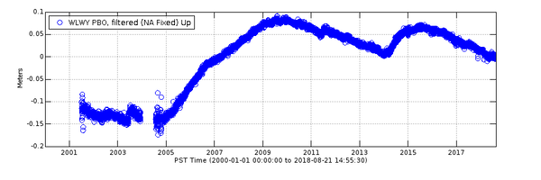
Vertical deformation at GPS station WLWY during 2001-2018
Data from continuous GPS stations indicate how the ground is moving over time. Station WLWY, near White Lake on the Sour Creek resurgent dome in Yellowstone caldera, has been operating since 2001. This plot shows vertical ground motion recorded at the site.
Data from continuous GPS stations indicate how the ground is moving over time. Station WLWY, near White Lake on the Sour Creek resurgent dome in Yellowstone caldera, has been operating since 2001. This plot shows vertical ground motion recorded at the site.

This morning, USGS scientists flying over fissure 8 noticed a change in the vent
This morning, USGS scientists flying over fissure 8 noticed a change in the vent from yesterday. Gas jets were throwing spatter—fragments of glassy lava (light gray deposits)—from small incandescent areas deep within the cone. This activity is an indication that the lower East Rift Zone eruption may be paused rather than pau (over).
This morning, USGS scientists flying over fissure 8 noticed a change in the vent from yesterday. Gas jets were throwing spatter—fragments of glassy lava (light gray deposits)—from small incandescent areas deep within the cone. This activity is an indication that the lower East Rift Zone eruption may be paused rather than pau (over).

Echinus temperature record during October 17-20, 2017
Temperature record from Echinus geyser outflow channel for October 17–20, 2017. The plot captures a time when the geyser went from occasional eruptions to semi-regular eruptions (signified by temperature spikes after about 12:00 on October 18) occurring about every 2 hours.
Temperature record from Echinus geyser outflow channel for October 17–20, 2017. The plot captures a time when the geyser went from occasional eruptions to semi-regular eruptions (signified by temperature spikes after about 12:00 on October 18) occurring about every 2 hours.

Conditions evolve at ocean entry, in Kīlauea Volcano's lower East Rift Zone
View from this morning's helicopter overflight of the Pohoiki boat ramp at Isaac Hale Park shows black sand, transported to the southwest by longshore currents, blocking the entrance to the small boat harbor.
View from this morning's helicopter overflight of the Pohoiki boat ramp at Isaac Hale Park shows black sand, transported to the southwest by longshore currents, blocking the entrance to the small boat harbor.