


Summary: The Earth observation data archived here have plenty of value to the study of aquatic ecosystems. Landsat satellites can capture harmful algal blooms, for example. Spaceborne sensors can also record land surface temperatures, and that includes water surfaces.
Priority Landscapes: San Francisco Bay-Delta
Active
By Land Management Research Program
September 22, 2022
The San Francisco Bay-Delta PES is one way that USGS continues to provide science for the restoration and conservation of the SF Bay and its watershed. USGS research topics range from wetland restoration in the Bay to restoring habitat for anadromous fish (e.g., salmon) in the uplands. USGS has made several important discoveries critical to the fundamental understanding of this system and continues to conduct critical work necessary to improve the restore of a system faced with multiple pressures including climate change. Within the PES we combine our capacities in the multiple disciplines necessary to conduct the research to provide information needed by decision makers across various agencies.
San Francisco Bay-Delta Research
San Francisco Bay-Delta Research
Avian Ecology and Multi-Species Habitat Use in Pacific Coast Estuaries
Waterbirds such as shorebirds, waders, and ducks depend on healthy and productive estuaries to “fuel up” for long distance migrations along the Pacific Flyway. Estuarine ecosystems include a mosaic of managed, natural, and restoring wetlands, and provide critical stop-over and wintering areas for federally protected migratory bird species. USGS WERC’s Dr. Susan De La Cruz works with federal, state...
Ecological Effects of Contaminants
Whereas the other themes of the Contaminant Ecology Research Program focus on where, why, and how contaminants cycle and bioaccumulate in ecological systems, this theme is focused on determining what happens at environmentally relevant concentrations.
Ecology and Population Dynamics of Ridgway's Rails along the West Coast of the U.S.
The Ridgway’s rail is a federal and state listed endangered species that occurs in wetlands along the Pacific Coast and from the Lower Colorado River drainage to southern Baja California. Three subspecies of Ridgway’s rail are found within the United States: the California Ridgway’s Rail, Yuma Ridgway’s rail, and Light-footed Ridgway’s rail. All three subspecies have declined since 1900 as a...
Coastal Ecosystem Response to Sea-level Rise
USGS WERC’s Dr. Karen Thorne, her team of reseachers, and her partners are currently taking a local site network approach to describe current and future conditions and projected responses of coastal ecosystems to sea-level rise and other stressors. The Coastal Ecosystem Response to Climate Change (CERCC) program’s goal is to understand how ecosystems vary in their ability to keep up with sea-level...
Ecological Stressors - Rocky Coastlines, Mangroves, Marshes, Droughts, and Storms
Coastal estuaries that contain marshes and mangroves are currently being reshaped by changing ocean and atmospheric conditions through prolong drought, sea-level rise and increased extreme storm events. Many projected increases in sea-level are expected to result in loss of tidal wetlands and their component species. In addition, changing sediment loads, extreme tide and storm events, and shifting...
Wetland Restoration in the San Francisco Bay Delta and Pacific Northwest
Estuaries and healthy coastal habitats are among the most productive ecosystems on Earth. They provide a variety of benefits, including habitat and food for fish and wildlife, flood and erosion protection, improved water quality, increased carbon sequestration, as well as beautiful scenery and opportunities for recreation. Along the U.S. Pacific Coast, both the San Francisco Bay estuary and the...
Modeling Sea-Level Rise in San Francisco Bay Estuary
With sea level rise, how will the coastal habitats of the San Francisco Bay Estuary change over the next 100 years? Mapping and modeling studies by Dr. Karen Thorne, WERC scientists, and partners have produced scenarios for this important coastal ecosystem.
Waterbird Breeding Ecology and Management
The San Francisco Bay is designated as a site of hemispheric importance to shorebirds and annually supports over one million waterbirds. Within the USGS WERC waterbird breeding ecology program, Dr. Josh Ackerman and partners are studying habitat selection, movements, and factors influencing waterbird nest success and chick growth and survival.
Contaminants in Waterbirds and Effects on Avian Reproduction
California’s Central Valley and San Francisco Bay Estuary have a long history of mercury contamination from past mercury mining and gold extraction. Waterbirds are particularly susceptible to mercury because of their use of wetland habitats where methylmercury (the most toxic and biologically available form) is produced and relatively low methylmercury exposure can reduce reproductive success...
Mercury Bioaccumulation in Wetlands
Wetlands provide numerous ecosystem services, but also can be sources of methylmercury production and export. Click the next tab to learn how WERC's Dr. Josh Ackerman is evaluating the ecological factors that drive contaminant bioaccumulation in wetland-dependent fish and wildlife.
Reproductive Success of Black-Crowned Night-Herons and Snowy Egrets on Alcatraz Island
Years after the last inmate departed Alcatraz Island, waterbirds like Black-crowned Night Herons and Snowy Egrets still make the forbidding island their home. The National Park Service has requested the aid of WERC’s Dr. Pete Coates to inform efforts to expand visitor access to the Island, and simultaneously maintain healthy waterbird populations.
Food Web and Invertebrate Ecology Studies in Pacific Coast Estuaries
Invertebrate communities provide food for several economically and ecologically important fish and waterbird species in coastal estuaries. Scientists at the WERC San Francisco Bay Estuary Field Station specialize in studying foraging ecology of waterbirds and fishes, general food web dynamics across estuaries, and the effects of habitat restoration and other factors on waterbird prey availability.
Eyes on Earth Episode 70 - ECOSTRESS and Aquatic Ecosystems
Summary: The Earth observation data archived here have plenty of value to the study of aquatic ecosystems. Landsat satellites can capture harmful algal blooms, for example. Spaceborne sensors can also record land surface temperatures, and that includes water surfaces.

Landsat 9 image of San Francisco Bay, California
This natural color Landsat 9 image from December 10, 2021 shows the cities of San Francisco, San Jose, and Oakland surrounding the San Francisco Bay. The bay is the largest estuary on the west coast and includes a patchwork of mud flats, salt marshes, and salt ponds.
This natural color Landsat 9 image from December 10, 2021 shows the cities of San Francisco, San Jose, and Oakland surrounding the San Francisco Bay. The bay is the largest estuary on the west coast and includes a patchwork of mud flats, salt marshes, and salt ponds.

Intertidal biofilm in San Francisco Bay, California
Intertidal biofilm, a slimy green layer of fungi and bacteria growing on top of mud, inhabits mudflats and is an essential component of shorebirds’ diets in San Francisco Bay, California.
Intertidal biofilm, a slimy green layer of fungi and bacteria growing on top of mud, inhabits mudflats and is an essential component of shorebirds’ diets in San Francisco Bay, California.
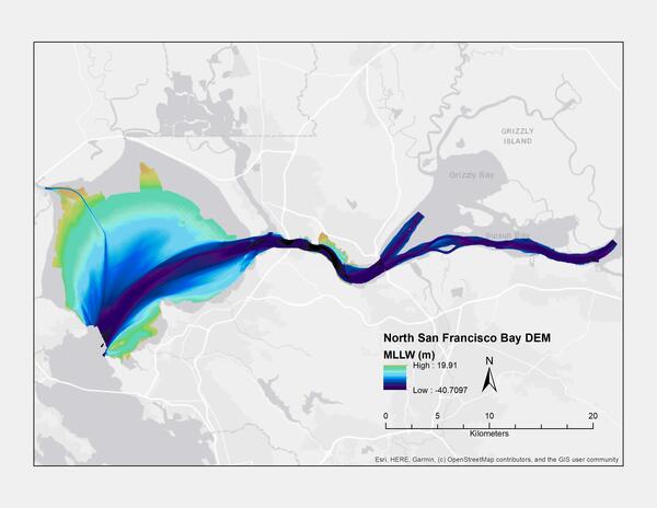
Bathymetric map of the northern portion of San Francisco Bay (MLLW)
Digital elevation model (DEM) of northern San Francisco Bay, California, created using bathymetry data collected between 1999 and 2016 (MLLW)
Digital elevation model (DEM) of northern San Francisco Bay, California, created using bathymetry data collected between 1999 and 2016 (MLLW)

Western sandpiper in San Francisco Bay
A Western sandpiper in San Francisco Bay.
A Western sandpiper in San Francisco Bay.

Conducting a high tide waterbird survey on San Fransisco Bay
San Francisco Bay and the surrounding wetlands and ponds provide important habitat for waterfowl and shorebirds.
San Francisco Bay and the surrounding wetlands and ponds provide important habitat for waterfowl and shorebirds.

Striped Bass diet sampling in the San Francisco Estuary
Sampling Striped Bass for diet items in the San Francisco Estuary.
Sampling Striped Bass for diet items in the San Francisco Estuary.

Caspian Terns on Island at NWR
Caspian terns (Hydroprogne caspia) on Island 11 in Pond A16, Don Edwards San Francisco Bay National Wildlife Refuge, California. USGS biologists, at the request of the U.S. Army Corps of Engineers and U.S. Fish and Wildlife Service, used lifelike models of Caspian terns to attract these waterbirds to newly-constructed habitat in the Bay.
Caspian terns (Hydroprogne caspia) on Island 11 in Pond A16, Don Edwards San Francisco Bay National Wildlife Refuge, California. USGS biologists, at the request of the U.S. Army Corps of Engineers and U.S. Fish and Wildlife Service, used lifelike models of Caspian terns to attract these waterbirds to newly-constructed habitat in the Bay.
The San Francisco Bay-Delta PES is one way that USGS continues to provide science for the restoration and conservation of the SF Bay and its watershed. USGS research topics range from wetland restoration in the Bay to restoring habitat for anadromous fish (e.g., salmon) in the uplands. USGS has made several important discoveries critical to the fundamental understanding of this system and continues to conduct critical work necessary to improve the restore of a system faced with multiple pressures including climate change. Within the PES we combine our capacities in the multiple disciplines necessary to conduct the research to provide information needed by decision makers across various agencies.
San Francisco Bay-Delta Research
San Francisco Bay-Delta Research
Avian Ecology and Multi-Species Habitat Use in Pacific Coast Estuaries
Waterbirds such as shorebirds, waders, and ducks depend on healthy and productive estuaries to “fuel up” for long distance migrations along the Pacific Flyway. Estuarine ecosystems include a mosaic of managed, natural, and restoring wetlands, and provide critical stop-over and wintering areas for federally protected migratory bird species. USGS WERC’s Dr. Susan De La Cruz works with federal, state...
Ecological Effects of Contaminants
Whereas the other themes of the Contaminant Ecology Research Program focus on where, why, and how contaminants cycle and bioaccumulate in ecological systems, this theme is focused on determining what happens at environmentally relevant concentrations.
Ecology and Population Dynamics of Ridgway's Rails along the West Coast of the U.S.
The Ridgway’s rail is a federal and state listed endangered species that occurs in wetlands along the Pacific Coast and from the Lower Colorado River drainage to southern Baja California. Three subspecies of Ridgway’s rail are found within the United States: the California Ridgway’s Rail, Yuma Ridgway’s rail, and Light-footed Ridgway’s rail. All three subspecies have declined since 1900 as a...
Coastal Ecosystem Response to Sea-level Rise
USGS WERC’s Dr. Karen Thorne, her team of reseachers, and her partners are currently taking a local site network approach to describe current and future conditions and projected responses of coastal ecosystems to sea-level rise and other stressors. The Coastal Ecosystem Response to Climate Change (CERCC) program’s goal is to understand how ecosystems vary in their ability to keep up with sea-level...
Ecological Stressors - Rocky Coastlines, Mangroves, Marshes, Droughts, and Storms
Coastal estuaries that contain marshes and mangroves are currently being reshaped by changing ocean and atmospheric conditions through prolong drought, sea-level rise and increased extreme storm events. Many projected increases in sea-level are expected to result in loss of tidal wetlands and their component species. In addition, changing sediment loads, extreme tide and storm events, and shifting...
Wetland Restoration in the San Francisco Bay Delta and Pacific Northwest
Estuaries and healthy coastal habitats are among the most productive ecosystems on Earth. They provide a variety of benefits, including habitat and food for fish and wildlife, flood and erosion protection, improved water quality, increased carbon sequestration, as well as beautiful scenery and opportunities for recreation. Along the U.S. Pacific Coast, both the San Francisco Bay estuary and the...
Modeling Sea-Level Rise in San Francisco Bay Estuary
With sea level rise, how will the coastal habitats of the San Francisco Bay Estuary change over the next 100 years? Mapping and modeling studies by Dr. Karen Thorne, WERC scientists, and partners have produced scenarios for this important coastal ecosystem.
Waterbird Breeding Ecology and Management
The San Francisco Bay is designated as a site of hemispheric importance to shorebirds and annually supports over one million waterbirds. Within the USGS WERC waterbird breeding ecology program, Dr. Josh Ackerman and partners are studying habitat selection, movements, and factors influencing waterbird nest success and chick growth and survival.
Contaminants in Waterbirds and Effects on Avian Reproduction
California’s Central Valley and San Francisco Bay Estuary have a long history of mercury contamination from past mercury mining and gold extraction. Waterbirds are particularly susceptible to mercury because of their use of wetland habitats where methylmercury (the most toxic and biologically available form) is produced and relatively low methylmercury exposure can reduce reproductive success...
Mercury Bioaccumulation in Wetlands
Wetlands provide numerous ecosystem services, but also can be sources of methylmercury production and export. Click the next tab to learn how WERC's Dr. Josh Ackerman is evaluating the ecological factors that drive contaminant bioaccumulation in wetland-dependent fish and wildlife.
Reproductive Success of Black-Crowned Night-Herons and Snowy Egrets on Alcatraz Island
Years after the last inmate departed Alcatraz Island, waterbirds like Black-crowned Night Herons and Snowy Egrets still make the forbidding island their home. The National Park Service has requested the aid of WERC’s Dr. Pete Coates to inform efforts to expand visitor access to the Island, and simultaneously maintain healthy waterbird populations.
Food Web and Invertebrate Ecology Studies in Pacific Coast Estuaries
Invertebrate communities provide food for several economically and ecologically important fish and waterbird species in coastal estuaries. Scientists at the WERC San Francisco Bay Estuary Field Station specialize in studying foraging ecology of waterbirds and fishes, general food web dynamics across estuaries, and the effects of habitat restoration and other factors on waterbird prey availability.
Eyes on Earth Episode 70 - ECOSTRESS and Aquatic Ecosystems
Summary: The Earth observation data archived here have plenty of value to the study of aquatic ecosystems. Landsat satellites can capture harmful algal blooms, for example. Spaceborne sensors can also record land surface temperatures, and that includes water surfaces.
Summary: The Earth observation data archived here have plenty of value to the study of aquatic ecosystems. Landsat satellites can capture harmful algal blooms, for example. Spaceborne sensors can also record land surface temperatures, and that includes water surfaces.
Landsat 9 image of San Francisco Bay, California
This natural color Landsat 9 image from December 10, 2021 shows the cities of San Francisco, San Jose, and Oakland surrounding the San Francisco Bay. The bay is the largest estuary on the west coast and includes a patchwork of mud flats, salt marshes, and salt ponds.
This natural color Landsat 9 image from December 10, 2021 shows the cities of San Francisco, San Jose, and Oakland surrounding the San Francisco Bay. The bay is the largest estuary on the west coast and includes a patchwork of mud flats, salt marshes, and salt ponds.
Intertidal biofilm in San Francisco Bay, California
Intertidal biofilm, a slimy green layer of fungi and bacteria growing on top of mud, inhabits mudflats and is an essential component of shorebirds’ diets in San Francisco Bay, California.
Intertidal biofilm, a slimy green layer of fungi and bacteria growing on top of mud, inhabits mudflats and is an essential component of shorebirds’ diets in San Francisco Bay, California.
Bathymetric map of the northern portion of San Francisco Bay (MLLW)
Digital elevation model (DEM) of northern San Francisco Bay, California, created using bathymetry data collected between 1999 and 2016 (MLLW)
Digital elevation model (DEM) of northern San Francisco Bay, California, created using bathymetry data collected between 1999 and 2016 (MLLW)
Western sandpiper in San Francisco Bay
A Western sandpiper in San Francisco Bay.
A Western sandpiper in San Francisco Bay.
Conducting a high tide waterbird survey on San Fransisco Bay
San Francisco Bay and the surrounding wetlands and ponds provide important habitat for waterfowl and shorebirds.
San Francisco Bay and the surrounding wetlands and ponds provide important habitat for waterfowl and shorebirds.
Striped Bass diet sampling in the San Francisco Estuary
Sampling Striped Bass for diet items in the San Francisco Estuary.
Sampling Striped Bass for diet items in the San Francisco Estuary.
Caspian Terns on Island at NWR
Caspian terns (Hydroprogne caspia) on Island 11 in Pond A16, Don Edwards San Francisco Bay National Wildlife Refuge, California. USGS biologists, at the request of the U.S. Army Corps of Engineers and U.S. Fish and Wildlife Service, used lifelike models of Caspian terns to attract these waterbirds to newly-constructed habitat in the Bay.
Caspian terns (Hydroprogne caspia) on Island 11 in Pond A16, Don Edwards San Francisco Bay National Wildlife Refuge, California. USGS biologists, at the request of the U.S. Army Corps of Engineers and U.S. Fish and Wildlife Service, used lifelike models of Caspian terns to attract these waterbirds to newly-constructed habitat in the Bay.