
Lares, Puerto Rico Landslide Monitoring Station
Active
By Landslide Hazards Program
February 13, 2023
The Lares monitoring site is in the western portion of the island. The site is heavily vegetated with steep slopes and relatively low elevation and is underlain by Tertiary-Cretaceous volcaniclastic rock.
Media

Lares, Puerto Rico Landslide Monitoring Site. The Lares monitoring site is in the western portion of the island. The site is heavily vegetated with steep slopes and relatively low elevation, and is underlain by Tertiary-Cretaceous volcaniclastic rock.
Sources/Usage: Public Domain. View Media Details
Media

Kiara Cunillera installs sensors at the Lares, Puerto Rico Landslide Monitoring Site.
Sources/Usage: Public Domain. View Media Details
Rainfall | Soil Water Content, Soil Suction, and Ground Water Pressure | Battery Voltage
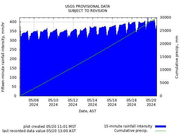
Rainfall
Media
Remote image Url
Sources/Usage: Public Domain. View Media Details
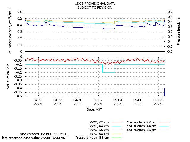
Soil-Water Content, Soil Suction, and Ground Water Pressure
Media
Remote image Url
Sources/Usage: Public Domain. View Media Details
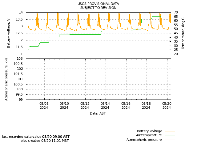
Battery Voltage
Media
Remote image Url
Sources/Usage: Public Domain. View Media Details
The Lares monitoring site is in the western portion of the island. The site is heavily vegetated with steep slopes and relatively low elevation and is underlain by Tertiary-Cretaceous volcaniclastic rock.
Media
Lares, Puerto Rico Landslide Monitoring Site. The Lares monitoring site is in the western portion of the island. The site is heavily vegetated with steep slopes and relatively low elevation, and is underlain by Tertiary-Cretaceous volcaniclastic rock.
Sources/Usage: Public Domain. View Media Details
Media
Kiara Cunillera installs sensors at the Lares, Puerto Rico Landslide Monitoring Site.
Sources/Usage: Public Domain. View Media Details
Rainfall | Soil Water Content, Soil Suction, and Ground Water Pressure | Battery Voltage
Rainfall
Media
Remote image Url
Sources/Usage: Public Domain. View Media Details
Soil-Water Content, Soil Suction, and Ground Water Pressure
Media
Remote image Url
Sources/Usage: Public Domain. View Media Details
Battery Voltage
Media
Remote image Url
Sources/Usage: Public Domain. View Media Details