
USGS scientists investigate trees knocked over by the tsunami at the mouth of Taan Fjord. Flow depth here was likely 5 m based on the height of branches stripped off trees in the background. This event had the 4th highest tsunami runup ever recorded.
Images
Browse images from a wide range of science topics covered by USGS.
Filter Total Items: 902

Surveying the Taan Fjord tsunami runup
USGS scientists investigate trees knocked over by the tsunami at the mouth of Taan Fjord. Flow depth here was likely 5 m based on the height of branches stripped off trees in the background. This event had the 4th highest tsunami runup ever recorded.

Geologists' camp on Unga Island, Alaska
USGS geologists' camp overlooking Unga Village on Unga Island, Alaska.
USGS geologists' camp overlooking Unga Village on Unga Island, Alaska.

Landslide Spreads 6 Miles Across Glacier Bay National Park
On June 28, 2016, a 4,000-foot-high mountainside in Glacier Bay National Park and Preserve collapsed, sending rocky debris equivalent to 60 million mid-size SUVs tumbling onto nearby Lamplugh Glacier.
On June 28, 2016, a 4,000-foot-high mountainside in Glacier Bay National Park and Preserve collapsed, sending rocky debris equivalent to 60 million mid-size SUVs tumbling onto nearby Lamplugh Glacier.

Collecting seismic data in Taan Fjord
USGS scientists collect seismic data to image the 2015 Taan Fjord landslide in southeast Alaska.
USGS scientists collect seismic data to image the 2015 Taan Fjord landslide in southeast Alaska.

Scientist sampling a stream in the drainage of the Agashashok River
Chris Zimmerman sampling a stream in the drainage of the Agashashok River which is in the Boreal-Arctic transition of the Brooks Range in Noatak National Park and Preserve, Kobuk Valley National Park. This is part of the Hydro-Ecoloy of Arctic Thawing (HEAT) project.
Chris Zimmerman sampling a stream in the drainage of the Agashashok River which is in the Boreal-Arctic transition of the Brooks Range in Noatak National Park and Preserve, Kobuk Valley National Park. This is part of the Hydro-Ecoloy of Arctic Thawing (HEAT) project.

An aerial view of a stream in the Agashashok River watershed
A stream type at the Boreal-Arctic transition of the Brooks Range, Noatak National Park and Preserve, Kobuk Valley National Park. The stream is part of the Agashashok River watershed. This is part of the Hydro-Ecoloy of Arctic Thawing (HEAT) project.
A stream type at the Boreal-Arctic transition of the Brooks Range, Noatak National Park and Preserve, Kobuk Valley National Park. The stream is part of the Agashashok River watershed. This is part of the Hydro-Ecoloy of Arctic Thawing (HEAT) project.

A stream in the Agashashok River watershed
A stream type at the Boreal-Arctic transition of the Brooks Range, Noatak National Park and Preserve, Kobuk Valley National Park. This stream is in the Agashashok River watershed. This is part of the Hydro-Ecoloy of Arctic Thawing (HEAT) project.
A stream type at the Boreal-Arctic transition of the Brooks Range, Noatak National Park and Preserve, Kobuk Valley National Park. This stream is in the Agashashok River watershed. This is part of the Hydro-Ecoloy of Arctic Thawing (HEAT) project.


Sorting aquatic macroinvertebrates in the field
Three researchers from the University of Waterloo hunt for aquatic insects among the detritus scooped from the lake’s nearshore zone.
Three researchers from the University of Waterloo hunt for aquatic insects among the detritus scooped from the lake’s nearshore zone.

Fyke net contents from a lake near Atqasuk, Alaska
Contents of the fyke net that was set in the lake near Atqasuk in 2016. All sticklebacks.
Contents of the fyke net that was set in the lake near Atqasuk in 2016. All sticklebacks.

A flock of Black-legged Kittiwakes foraging on small fish in the water
A flock of Black-legged Kittiwakes foraging on Pacific sand lance near Gull Island.
A flock of Black-legged Kittiwakes foraging on Pacific sand lance near Gull Island.

Common Murres stand at the edge of their colony on Gull Island
Common Murres stand at the edge of their colony on Gull Island, Cook Inlet on July 23, 2016.
Common Murres stand at the edge of their colony on Gull Island, Cook Inlet on July 23, 2016.

Common Murres in the water
Large amount of Common Murres in the water

Eklutna River traveling under two bridges
Eklutna River traveling under two bridges
Eklutna River traveling under two bridges

Male Lapland Longspur in dwarf shrub mat habitat
Male Lapland Longspur in dwarf shrub mat habitat. This photo was taken on the Seward Peninsula as part of the Changing Arctic Ecosystem Boreal-Arctic Transition Zone program.
Male Lapland Longspur in dwarf shrub mat habitat. This photo was taken on the Seward Peninsula as part of the Changing Arctic Ecosystem Boreal-Arctic Transition Zone program.
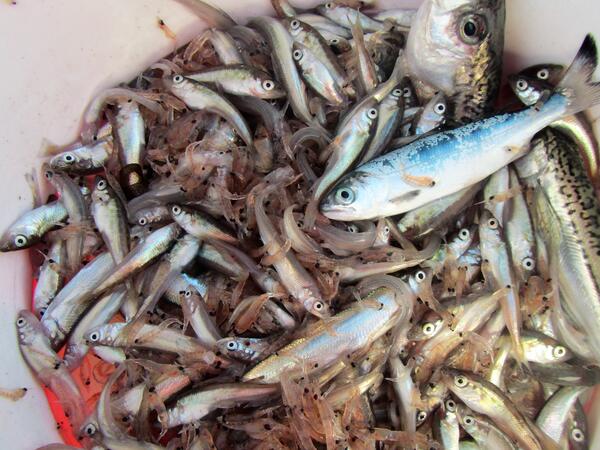
Catch of forage fish from a trawl in Cook Inlet, Alaska
Catch of forage fish from a trawl in Cook Inlet, Alaska. Trawling was part of an assessment of abundance, distribution and species composition of forage fish in marine waters in lower Cook Inlet.
Catch of forage fish from a trawl in Cook Inlet, Alaska. Trawling was part of an assessment of abundance, distribution and species composition of forage fish in marine waters in lower Cook Inlet.


A Horned Puffin flying over the water
A Horned Puffin flying over the water
A Horned Puffin flying over the water

Horned Puffin, near Chisik Island in Lower Cook Inlet, Alaska
Horned Puffin, one of the species affected by a recent seabird die-off in the Pribilof Islands, AK. Near Chisik Island in Lower Cook Inlet, Alaska
Horned Puffin, one of the species affected by a recent seabird die-off in the Pribilof Islands, AK. Near Chisik Island in Lower Cook Inlet, Alaska


Molybdenite mineral coating on a fractured surface
Molybdenite mineral coating on a fractured surface in Tertiary granite north of Lake Clark
Molybdenite mineral coating on a fractured surface in Tertiary granite north of Lake Clark