
This image shows a 3d visualization of geophysical data collected over the Idaho Cobalt Belt by the Earth Mapping Resources Initiative (Earth MRI).
Images
Images intro.
Filter Total Items: 28

3d geophysical map of the Idaho Cobalt Belt
This image shows a 3d visualization of geophysical data collected over the Idaho Cobalt Belt by the Earth Mapping Resources Initiative (Earth MRI).

Medicine Bow LLFA Survey Map
A map of the airborne geophysical survey area in the Medicine Mountains region of Wyoming
A map of the airborne geophysical survey area in the Medicine Mountains region of Wyoming

Mineral Systems Map of the United States
Maps showing parts of 23 mineral systems that could host critical mineral resources in the United States. These areas are used to prioritize data collection and analysis by Earth MRI.
Maps showing parts of 23 mineral systems that could host critical mineral resources in the United States. These areas are used to prioritize data collection and analysis by Earth MRI.

Montana
A view of the Boulder Mountains from US-12 west of Helena. These mountains lie at the north end of the Boulder Batholith.
A view of the Boulder Mountains from US-12 west of Helena. These mountains lie at the north end of the Boulder Batholith.

Aircraft with Geophysical Survey Equipment
A typical survey airplane. The magnetic sensor is placed in an extension on the back of the airplane to reduce the impact of the airplane’s own magnetic field.
A typical survey airplane. The magnetic sensor is placed in an extension on the back of the airplane to reduce the impact of the airplane’s own magnetic field.

Pennington Mountain Critical Minerals Earth MRI Geophysical Scan
The anomaly at Pennington Mountain is visible in the geophysical data collected in aerial surveys conducted in 2021.
The anomaly at Pennington Mountain is visible in the geophysical data collected in aerial surveys conducted in 2021.

Pennington Mountain Rock with Critical Minerals
A fine-grained volcanic rock (trachyte) that hosts rare earth elements, niobium, and zirconium, all which are considered critical mineral resources. This rock was found on Pennington Mountain in Maine. Image courtesy of Chunzeng Wang, University of Maine-Presque Isle.
A fine-grained volcanic rock (trachyte) that hosts rare earth elements, niobium, and zirconium, all which are considered critical mineral resources. This rock was found on Pennington Mountain in Maine. Image courtesy of Chunzeng Wang, University of Maine-Presque Isle.

Piper Navajo fixed-wing aircraft with rear facing stinger magnetometer
A Piper Navajo fixed-wing aircraft with rear facing stinger magnetometer. Credit: New-Sense Geophysics Limited
A Piper Navajo fixed-wing aircraft with rear facing stinger magnetometer. Credit: New-Sense Geophysics Limited

Helicopter with forward facing stinger magnetometer
An AS350 helicopter with forward facing stinger magnetometer. Credit: New-Sense Geophysics Limited
An AS350 helicopter with forward facing stinger magnetometer. Credit: New-Sense Geophysics Limited

Earth MRI Aircraft with Boom
Airborne geophysical surveys make use of a boom with sensitive equipment installed on small aircraft.
Airborne geophysical surveys make use of a boom with sensitive equipment installed on small aircraft.

Earth MRI Airborne Geophysical Survey Helicopter with Boom
A helicopter with a boom that contains sensitive equipment for conducting airborne geophysical surveys.
A helicopter with a boom that contains sensitive equipment for conducting airborne geophysical surveys.

MTLLFareamap.JPG
Survey area for low-flying helicopter soon to be visible in six Montana counties, including Helena, the Elkhorn Mountains, Bull Mountain and the Tobacco Root Mountains.
Survey area for low-flying helicopter soon to be visible in six Montana counties, including Helena, the Elkhorn Mountains, Bull Mountain and the Tobacco Root Mountains.

Low-level flight helicopter with stinger
Helicopter conducting low-level flights. Image courtesy Sander Geophysics Ltd.
Helicopter conducting low-level flights. Image courtesy Sander Geophysics Ltd.

Pennington Mountain Critical Minerals
Geologists in the field at Pennington Mountain. The orange instrument is a portable gamma spectrometer. University of Maine-Presque Isle professor Chunzeng Wang (the lead author) is in front, Preston Bass is carrying the meter.
Geologists in the field at Pennington Mountain. The orange instrument is a portable gamma spectrometer. University of Maine-Presque Isle professor Chunzeng Wang (the lead author) is in front, Preston Bass is carrying the meter.

Airborne Geophysical Survey Helicopter in Nevada
A low-flying helicopter towing a geophysical device collects scientific data on groundwater and geology. Information collected during these surveys can help with studying critical mineral resources, natural hazards and groundwater potential.
A low-flying helicopter towing a geophysical device collects scientific data on groundwater and geology. Information collected during these surveys can help with studying critical mineral resources, natural hazards and groundwater potential.

Airborne Geophysical Survey Helicopter with Cow
A helicopter rigged with an airborne geophysical survey collecting equipment. Information collected during these surveys can help with studying critical mineral resources, natural hazards and groundwater potential. A cow is here too.
A helicopter rigged with an airborne geophysical survey collecting equipment. Information collected during these surveys can help with studying critical mineral resources, natural hazards and groundwater potential. A cow is here too.
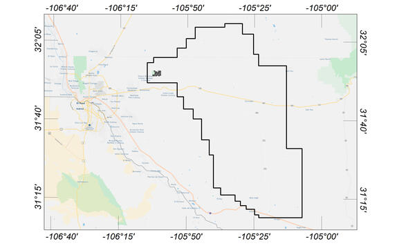
Flight area for Trans-Pecos aeromagnetic and radiometric survey
Map indicating flight area for Trans-Pecos aeromagnetic and radiometric survey. The survey area includes parts of El Paso and Hudspeth counties, Texas, and Otero County, New Mexico. Flights will begin in November 2020 and are expected to conclude in mid-January 2021.
Map indicating flight area for Trans-Pecos aeromagnetic and radiometric survey. The survey area includes parts of El Paso and Hudspeth counties, Texas, and Otero County, New Mexico. Flights will begin in November 2020 and are expected to conclude in mid-January 2021.

Earth MRI - Rare Minerals
Earth MRI - Rare Minerals
Earth MRI - Rare Minerals

Earth MRI - Common Uses of Rare Earth Elements
Earth MRI - Common Uses of Rare Earth Elements
Earth MRI - Common Uses of Rare Earth Elements

Earth MRI - Rare Earth Elements Deposit
Earth MRI - Rare Earth Elements Deposit
Earth MRI - Rare Earth Elements Deposit

Earth MRI - Forty mile River Watershed
Earth MRI - Forty mile River Watershed
Earth MRI - Forty mile River Watershed