
An HVO geologist encounters a small brush fire along the margin of the lobe that was active a few hundred meters upslope of the transfer station.
Images
Images intro.
Filter Total Items: 66

An Geologist encounters a small brush fire along the margin of the ...
An HVO geologist encounters a small brush fire along the margin of the lobe that was active a few hundred meters upslope of the transfer station.

Fire monitoring during wildfires
Fire monitoring during wildfires helps researchers understand the complex relationships among fuels, fire behavior, and fire effects. Santa Fe National Forest, New Mexico, 2014.
Fire monitoring during wildfires helps researchers understand the complex relationships among fuels, fire behavior, and fire effects. Santa Fe National Forest, New Mexico, 2014.

Monitoring fire effects at archaeological sites
Monitoring fire effects at archaeological sites provides critical information for fire planning and site preservation. Santa Fe National Forest, New Mexico, 2014.
Monitoring fire effects at archaeological sites provides critical information for fire planning and site preservation. Santa Fe National Forest, New Mexico, 2014.

Deploying fire instruments during a wildfire
Fire behavior instruments are deployed during wildfires and prescribed fires to provide data on the types of fire environments that damage archaeological resources
Fire behavior instruments are deployed during wildfires and prescribed fires to provide data on the types of fire environments that damage archaeological resources

Controlled fire studies provide data on archaeological sites impacts
Controlled experiments that simulate fire environments provide critical information for understanding how fire intensity and duration impact archaeological resources
Controlled experiments that simulate fire environments provide critical information for understanding how fire intensity and duration impact archaeological resources

Fire Damage in Yosemite National Park
The sequoia forests of Yosemite National Park rely on a fire ecology-based ecosystem. Periodic forest fires clear out underbrush and shade-tolerant trees like white fir trees, allowing sequoia seedlings to reach adulthood.
The sequoia forests of Yosemite National Park rely on a fire ecology-based ecosystem. Periodic forest fires clear out underbrush and shade-tolerant trees like white fir trees, allowing sequoia seedlings to reach adulthood.

LiDAR GPS Set Up Near Yarnell Fire
USGS scientists Jeff Cordova and Fletcher Brinkerhoff set up the LiDAR and GPS equipment to survey a burned watershed within the Yarnell Hill Fire.
USGS scientists Jeff Cordova and Fletcher Brinkerhoff set up the LiDAR and GPS equipment to survey a burned watershed within the Yarnell Hill Fire.

Burned Trees after wildfire in Gila National Forest
Burned trees along the trail into Hummingbird Saddle, Gila National Forest, New Mexico, where USGS scientists installed a rain gage.
Burned trees along the trail into Hummingbird Saddle, Gila National Forest, New Mexico, where USGS scientists installed a rain gage.

Native Fish and Wildfire
Colorado-native Rio Grande Cuttroat Trout salvaged after Medano Creek wildfire, Great Sand Dunes National Park, Colorado.
Colorado-native Rio Grande Cuttroat Trout salvaged after Medano Creek wildfire, Great Sand Dunes National Park, Colorado.

Medano Creek Wildfire
Medano Creek after wildfire.
Medano Creek after wildfire.

Aspen regeneration after stand-replacing fire
Aspen regeneration after stand-replacing fire in a seral aspen-conifer stand in the Jarbidge Mountains, Nevada
Aspen regeneration after stand-replacing fire in a seral aspen-conifer stand in the Jarbidge Mountains, Nevada

Smoke From Schultz Pass Forest Fire, Flagstaff, Arizona, June 20, 2010
Panorama (180 degree field of view) photograph of smoke rising from the Schultz Pass fire near Flagstaff, Arizona, at 1:34 p.m. on its day of ignition, June 20, 2010. Over the following 10 days, the fire burned an estimated 15,075 acres, or more than 23 square miles of northern Arizona forest, and cost more than $8.6 million to fight.
Panorama (180 degree field of view) photograph of smoke rising from the Schultz Pass fire near Flagstaff, Arizona, at 1:34 p.m. on its day of ignition, June 20, 2010. Over the following 10 days, the fire burned an estimated 15,075 acres, or more than 23 square miles of northern Arizona forest, and cost more than $8.6 million to fight.

A fire ecologist takes pictures of the location of the Red Eagle Fire.
A fire ecologist takes pictures of the location of the Red Eagle Fire in Montana, 2007.
A fire ecologist takes pictures of the location of the Red Eagle Fire in Montana, 2007.

Landsat 7 infrared image of wildfires near Yucca Valley, CA. July 2006
Landsat 7 infrared image of wildfires near Yucca Valley, California. July 2006
Landsat 7 infrared image of wildfires near Yucca Valley, California. July 2006

Post-fire Debris Flow
Debris Flow in Cable Canyon following the 2003 Old Fire in the San Bernardino Mountains, California.
Debris Flow in Cable Canyon following the 2003 Old Fire in the San Bernardino Mountains, California.

Southern California Neighborhood Scarred by Wildfire
Southern California neighborhood scarred by wildfire.
Southern California neighborhood scarred by wildfire.

Burned Juniper Trees From a Wildfire
Area of burned trees from a 2002 wildfire, caused by a lightning strike, at Mesa Verde National Park.
Area of burned trees from a 2002 wildfire, caused by a lightning strike, at Mesa Verde National Park.

Aftermath of 2000 Jasper Fire, Jewel Cave, SD
Photograph taken in 2001 of an area burned by the Jasper Fire that started on August 24, 2000, just west of Jewel Cave in the southern Black Hills of South Dakota. A total of about 84,000 acres was burned by the Jasper Fire.
Photograph taken in 2001 of an area burned by the Jasper Fire that started on August 24, 2000, just west of Jewel Cave in the southern Black Hills of South Dakota. A total of about 84,000 acres was burned by the Jasper Fire.
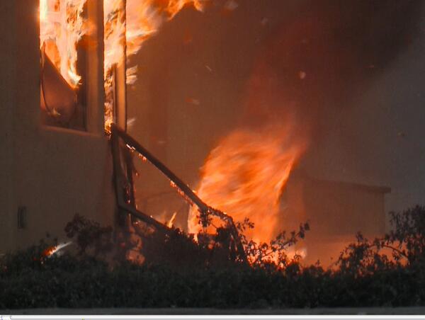
A Fire Tornado Swirls Near a Home in Southern California
A screenshot from the USGS film "Living with Fire".
A fire tornado swirls near a home in southern California. USGS is investigating the factors that dictate home loss from wildfires as part of the USGS Southern California Wildfire Risk Scenario Project.
Image courtesy of Tim Walton, Photo One Productions, CALFIRE. Shared with permission.

Prescribed Fire at Sunset in the Jemez Mountains, New Mexico
Sunset as seen through the smoke of a prescribed burn in the Jemez Mountains, New Mexico. The burn was conducted to restore fire as an ecosystem process and reduce hazardous tree densities and fuel loads due to more than 100 years of fire suppression. Foreground trees (Douglas-fir and aspen) were killed during the Cerro Grande fire in 2000.
Sunset as seen through the smoke of a prescribed burn in the Jemez Mountains, New Mexico. The burn was conducted to restore fire as an ecosystem process and reduce hazardous tree densities and fuel loads due to more than 100 years of fire suppression. Foreground trees (Douglas-fir and aspen) were killed during the Cerro Grande fire in 2000.

Tree-Killing Las Conchas Fire in New Mexico
USGS scientist Craig D. Allen observes the results of the extensive, tree-killing fire that consumed almost all above-ground biomass in this part of the Las Conchas Fire burn area in the Jemez Mountains, New Mexico. Photo taken in late August 2011, two months post-fire.
USGS scientist Craig D. Allen observes the results of the extensive, tree-killing fire that consumed almost all above-ground biomass in this part of the Las Conchas Fire burn area in the Jemez Mountains, New Mexico. Photo taken in late August 2011, two months post-fire.