


The May 12, 2008, Great Sichuan Earthquake, also called the Wenchuan Earthquake, occurred at 14:28 local time, in Sichuan Province, China. The earthquake magnitudes were Mw = 7.9 (USGS), Ms = 8.0 (Chinese Earthquake Administration). The epicenter was 80 km west-northwest of Chengdu, the capital city of Sichuan province.
David J Wald
Dr. Wald is a Seismologist with the USGS in Golden. He is involved in research, development & operations of several real-time earthquake information systems at the USGS National Earthquake Information Center. He developed and manages “ShakeMap”, “Did You Feel it?”, & is responsible for developing other systems for post-earthquake response & pre-earthquake mitigation, including ShakeCast.
Wald's scientific interests include the characterization of rupture processes from complex recent and historic earthquakes using combined geodetic, teleseismic, and strong motion data; waveform modelling and inversion; analysis of ground motion hazards and site effects; earthquake source physics; and modelling earthquake-induced landslides, liquefaction, and losses, macroseismic intensity, building damage, financial and human impact, rapid damage and impact assessment, earthquake scenario development and mitigation planning and drills, and communication with the media, public, and emergency managers.
Previously at Caltech, and now at the Colorado School of Mines, Wald has advised dozens of post-doctoral, graduate, and undergraduate student research projects. Wald directly supervises 10 PhD level scientists and 5 five BS and MS level support staff, and supervises several students. Wald serves on several PhD committees at this time. This research has resulted in more than 450 professional publications that David has authored or co-authored, including journal papers, USGS publication series, conference papers, and published abstracts.
Education:
Post-doctoral Fellow, Geophysics, National Research Council, USGS, Pasadena, 1995
Ph.D., Geophysics, California Institute of Technology, Pasadena, CA, 1993
M.S., Geophysics, University of Arizona, Tucson, AZ, 1986
B.S., Geology & Physics, St. Lawrence University, Canton, NY, 1984
Science and Products
Developing and Implementing an International Macroseismic Scale (IMS) for Earthquake Engineering, Earthquake Science, and Rapid Damage Assessment
The USGS “Did You Feel It” (DYFI) is an extremely popular way for members of the public to contribute to earthquake science and earthquake response. DYFI has been in operation for nearly two decades (1999-2019) in the U.S., and for nearly 15 years globally. During that period the amount of data collected is astounding: Over 5 million individual DYFI intensity reports—spanning all...
The Blind Zone of Earthquake Early Warning
Release Date: MAY 29, 2020 Residents in California, Oregon, and Washington have been told that earthquake early warning (EEW) is at their doorstep and will alert them to the shaking from an earthquake before it arrives. Some media reports have said there will be “up to a minute of warning”. The problem is, for onshore earthquakes these claims are exaggerated, and under some conditions a warning is...
Future Opportunities in Regional and Global Seismic Network Monitoring and Science
The past decade has seen improvements in computational efficiency, seismic data coverage, and communication technology - driven by societal expectation for timely, accurate information. While aspects of earthquake research have taken advantage of this evolution, the adoption of improvements in earthquake monitoring has not been fully leveraged. In real-time monitoring, earthquakes are...
Operational Earthquake Forecasting – Implementing a Real-Time System for California
It is well know that every earthquake can spawn others (e.g., as aftershocks), and that such triggered events can be large and damaging, as recently demonstrated by L’Aquila, Italy and Christchurch, New Zealand earthquakes. In spite of being an explicit USGS strategic-action priority (http://pubs.usgs.gov/of/2012/1088; page 32), the USGS currently lacks an automated system with which to...
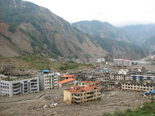
Damage from 2008 Great Sichuan Earthquake in China
The May 12, 2008, Great Sichuan Earthquake, also called the Wenchuan Earthquake, occurred at 14:28 local time, in Sichuan Province, China. The earthquake magnitudes were Mw = 7.9 (USGS), Ms = 8.0 (Chinese Earthquake Administration). The epicenter was 80 km west-northwest of Chengdu, the capital city of Sichuan province.
Science and Products
Developing and Implementing an International Macroseismic Scale (IMS) for Earthquake Engineering, Earthquake Science, and Rapid Damage Assessment
The USGS “Did You Feel It” (DYFI) is an extremely popular way for members of the public to contribute to earthquake science and earthquake response. DYFI has been in operation for nearly two decades (1999-2019) in the U.S., and for nearly 15 years globally. During that period the amount of data collected is astounding: Over 5 million individual DYFI intensity reports—spanning all...
The Blind Zone of Earthquake Early Warning
Release Date: MAY 29, 2020 Residents in California, Oregon, and Washington have been told that earthquake early warning (EEW) is at their doorstep and will alert them to the shaking from an earthquake before it arrives. Some media reports have said there will be “up to a minute of warning”. The problem is, for onshore earthquakes these claims are exaggerated, and under some conditions a warning is...
Future Opportunities in Regional and Global Seismic Network Monitoring and Science
The past decade has seen improvements in computational efficiency, seismic data coverage, and communication technology - driven by societal expectation for timely, accurate information. While aspects of earthquake research have taken advantage of this evolution, the adoption of improvements in earthquake monitoring has not been fully leveraged. In real-time monitoring, earthquakes are...
Operational Earthquake Forecasting – Implementing a Real-Time System for California
It is well know that every earthquake can spawn others (e.g., as aftershocks), and that such triggered events can be large and damaging, as recently demonstrated by L’Aquila, Italy and Christchurch, New Zealand earthquakes. In spite of being an explicit USGS strategic-action priority (http://pubs.usgs.gov/of/2012/1088; page 32), the USGS currently lacks an automated system with which to...
Damage from 2008 Great Sichuan Earthquake in China
The May 12, 2008, Great Sichuan Earthquake, also called the Wenchuan Earthquake, occurred at 14:28 local time, in Sichuan Province, China. The earthquake magnitudes were Mw = 7.9 (USGS), Ms = 8.0 (Chinese Earthquake Administration). The epicenter was 80 km west-northwest of Chengdu, the capital city of Sichuan province.
The May 12, 2008, Great Sichuan Earthquake, also called the Wenchuan Earthquake, occurred at 14:28 local time, in Sichuan Province, China. The earthquake magnitudes were Mw = 7.9 (USGS), Ms = 8.0 (Chinese Earthquake Administration). The epicenter was 80 km west-northwest of Chengdu, the capital city of Sichuan province.