
Is it true that there's oil in Yellowstone? Watch this month's Yellowstone Monthly update and find out.
Michael Poland
Mike Poland is a research geophysicist with the Cascades Volcano Observatory and the current Scientist-in-Charge of the Yellowstone Volcano Observatory.
Mike's area of specialization is volcano geodesy, which emphasizes the surface deformation and gravity fields associated with volcanic activity. This work involves the use of space-based technologies, like Interferometric Synthetic Aperture Radar (InSAR), as well as ground-based techniques, like microgravity surveys. Mike has taken part in studies on a variety of volcanic systems in the United States, including Mount St. Helens and other volcanoes of the Pacific Northwest, Kilauea and Mauna Loa volcanoes in Hawaii, and the Yellowstone caldera. His recent work has focused on using gravity change over time to understand the character of the fluids that drive volcanic unrest, and also on the potential of satellite data to improve forecasts of future changes in volcanic activity.
Science and Products
Filter Total Items: 147
")
Is there oil in Yellowstone? (Yellowstone Monthly Update - September 2024)
Is it true that there's oil in Yellowstone? Watch this month's Yellowstone Monthly update and find out.

New steam vent that formed in 2024 near Nymph Lake, Yellowstone National Park
New steam vent at the base of a hill north of Nymph Lake, west of the highway and between Norris Geyser Basin and Roaring Mountain. USGS photo by Mike Poland, September 1, 2024.
New steam vent at the base of a hill north of Nymph Lake, west of the highway and between Norris Geyser Basin and Roaring Mountain. USGS photo by Mike Poland, September 1, 2024.

Dead trees along the edge of Nuphar Lake, Yellowstone National Park, in summer 2024
Photo of dead trees along the edge of Nuphar Lake. The white staining at the base of the trees is a telltale sign that the trees were immersed in thermal water containing silica. USGS photo by Mike Poland, September 1, 2024.
Photo of dead trees along the edge of Nuphar Lake. The white staining at the base of the trees is a telltale sign that the trees were immersed in thermal water containing silica. USGS photo by Mike Poland, September 1, 2024.
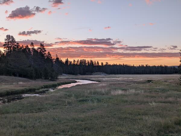
Gibbon River near Norris Geyser Basin in Yellowstone National Park
Gibbon River near Norris Geyser Basin in Yellowstone National Park at sunset. USGS Photo by Mike Poland, August 28, 2024.
Gibbon River near Norris Geyser Basin in Yellowstone National Park at sunset. USGS Photo by Mike Poland, August 28, 2024.
")
Biscuit Basin Update; 65th Anniversary — M7.3 Hebgen Lake Quake (Yellowstone Monthly Update - Aug 2024)
linkIn this month's video, we update you on the Biscuit Basin explosion on July 23, 2024, and discuss the 65th anniversary of the M7.3 Hegben Lake earthquake.
Biscuit Basin Update; 65th Anniversary — M7.3 Hebgen Lake Quake (Yellowstone Monthly Update - Aug 2024)
linkIn this month's video, we update you on the Biscuit Basin explosion on July 23, 2024, and discuss the 65th anniversary of the M7.3 Hegben Lake earthquake.
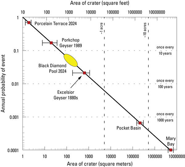
Plot of size versus annual probability for hydrothermal explosion craters in Yellowstone National Park
linkPlot of size versus annual probability for hydrothermal explosion craters in Yellowstone National Park. The line is a model based on the energy required to form a crater of a specific size, and it is fit to known hydrothermal explosion craters in Yellowstone National Park.

Satellite images of Biscuit Basin, Yellowstone National Park, before and after the July 23, 2024, hydrothermal explosion
linkThese satellite images, acquired by Planet, show Biscuit Basin, Yellowstone National Park, before and after the July 23, 2024, hydrothermal explosion. The before image is from July 21, 2024, and the after image is from July 24, 2024.
")
Hydrothermal Explosion in Yellowstone's Biscuit Basin (July 23, 2024)
What just happened at Biscuit Basin in Yellowstone National Park? Kaboom! Visitors witnessed a towering plume of steam, rock and mud rise several hundred feet into the air. The brief July 23 event was a classic example of a hydrothermal explosion, not a volcanic eruption.
What just happened at Biscuit Basin in Yellowstone National Park? Kaboom! Visitors witnessed a towering plume of steam, rock and mud rise several hundred feet into the air. The brief July 23 event was a classic example of a hydrothermal explosion, not a volcanic eruption.
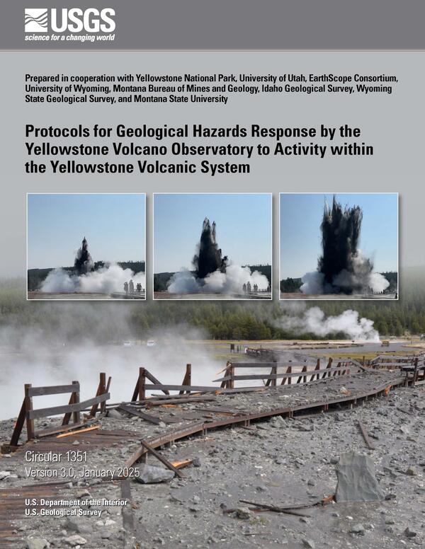
Cover of the Yellowstone Volcano Observatory response plan
Cover of the Yellowstone Volcano Observatory response plan for geological hazards in the Yellowstone region. The report can be accessed at https://pubs.usgs.gov/circ/1351/. Cover features a photograph by Mike Poland and frame captures from a video by Juliet Su.
Cover of the Yellowstone Volcano Observatory response plan for geological hazards in the Yellowstone region. The report can be accessed at https://pubs.usgs.gov/circ/1351/. Cover features a photograph by Mike Poland and frame captures from a video by Juliet Su.

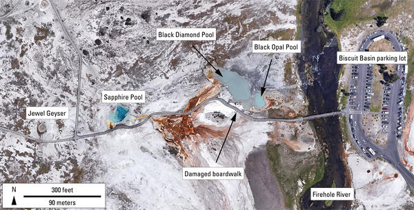
Aerial view of Biscuit Basin, Yellowstone National Park, showing debris deposited by the July 23, 2024, hydrothermal explosion from Black Diamond Pool
linkAerial view of Biscuit Basin, Yellowstone National Park, showing debris deposited by the July 23, 2024, hydrothermal explosion from Black Diamond Pool. Major features are labeled. The main debris field (within dashed yellow line) has a gray appearance. Photo taken by Joe Bueter, Yellowstone National Park, on July 23, 2024.
Map of major features in Biscuit Basin, Yellowstone National Park
Map of major thermal features in Biscuit Basin, Yellowstone National Park. Base map from Google Earth
Map of major thermal features in Biscuit Basin, Yellowstone National Park. Base map from Google Earth
")
Morning Glory Pool Was Blue? (Yellowstone Monthly Update - July 2024)
The beautiful Morning Glory pool is located near Old Faithful. However, it has changed over time because of people and past climate. But how?
The beautiful Morning Glory pool is located near Old Faithful. However, it has changed over time because of people and past climate. But how?

Animation of annual Yellowstone seismicity 2017-2023
This animation shows a map of of Yellowstone seismicity by year from 2017 through 2023. Earthquakes are red circles, with the circle size indicating earthquake magnitude. Gray lines are roads, black dashed line shows the caldera boundary, Yellowstone National Park is outlined by black dot-dashed line, and gray dashed lines denote state boundaries.
This animation shows a map of of Yellowstone seismicity by year from 2017 through 2023. Earthquakes are red circles, with the circle size indicating earthquake magnitude. Gray lines are roads, black dashed line shows the caldera boundary, Yellowstone National Park is outlined by black dot-dashed line, and gray dashed lines denote state boundaries.
")
Swimming Pools at Yellowstone? (Yellowstone Monthly Update - June 2024)
Up until the 1950s, visitors to the Old Faithful area could take a dip. Not at a geyser, but in a real swimming pool. The full story is in this month’s video update.
Up until the 1950s, visitors to the Old Faithful area could take a dip. Not at a geyser, but in a real swimming pool. The full story is in this month’s video update.
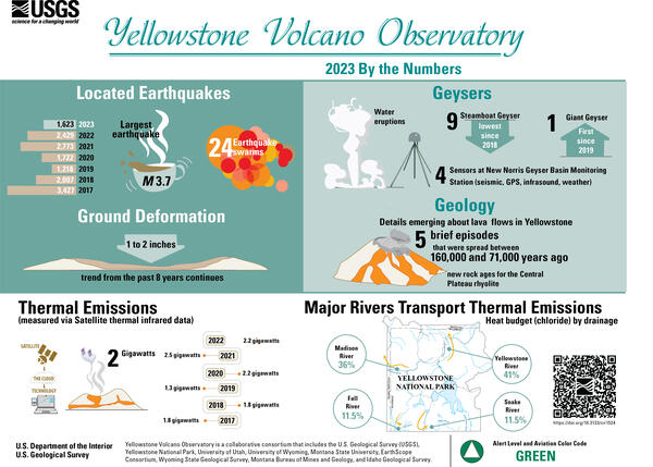
Infographic giving earthquake, deformation, thermal emission, and geyser statistics for the Yellowstone region for the year 2023
linkInfographic giving earthquake, deformation, thermal emission, and geyser statistics for the Yellowstone region for the year 2023. The graphic accompanies the Yellowstone Volcano Observatory 2023 annual report, freely available online athttps://pubs.usgs.gov/publication/cir1524.
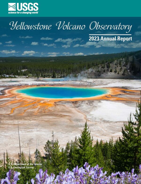
Front cover of the Yellowstone Volcano Observatory 2023 annual report
Front cover of the Yellowstone Volcano Observatory 2023 annual report, which includes a summary of earthquake, deformation, and geyser activity, as well as research investigations and other information. The report is freely available online athttps://pubs.usgs.gov/publication/cir1524.
Front cover of the Yellowstone Volcano Observatory 2023 annual report, which includes a summary of earthquake, deformation, and geyser activity, as well as research investigations and other information. The report is freely available online athttps://pubs.usgs.gov/publication/cir1524.
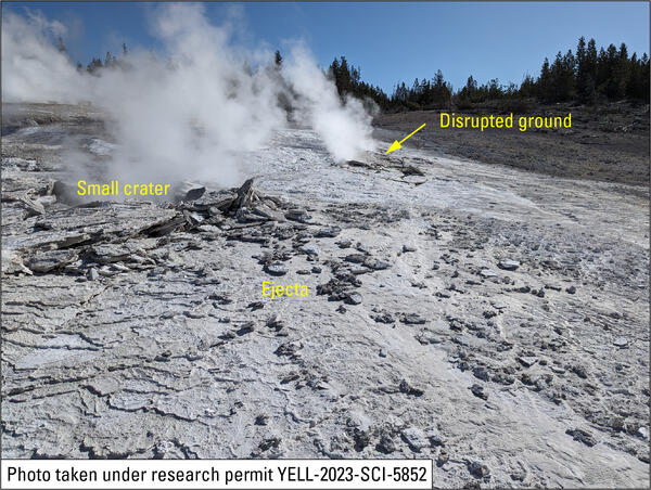
Site of April 15, 2024, hydrothermal explosion on Porcelain Terrace, Norris Geyser Basin, Yellowstone National Park
linkSite of April 15, 2024, hydrothermal explosion on Porcelain Terrace, Norris Geyser Basin, Yellowstone National Park. The small crater and disrupted ground are in silica sinter deposits that formed in the past two years, since water has been flowing from the terrace into Nuphar Lake (off photo to right), and angular fragments of ejecta on top of the sinter are
")
Mount St. Helens VS Yellowstone (Yellowstone Monthly Update - May 2024)
Mount St. Helens and Yellowstone are two of the most well-known volcanoes in the United States. They have some pretty obvious differences, but they have some similarities as well. So, just how similar are Mount St. Helens and Yellowstone?
Mount St. Helens and Yellowstone are two of the most well-known volcanoes in the United States. They have some pretty obvious differences, but they have some similarities as well. So, just how similar are Mount St. Helens and Yellowstone?

Seismic and infrasound data for the April 15, 2024, hydrothermal explosion on Porcelain Terrace at Norris Geyser Basin
linkSeismic and infrasound data for the April 15, 2024, hydrothermal explosion on Porcelain Terrace at Norris Geyser Basin. Top plot is seismic data from the YNM station, located at the Norris Geyser Basin Museum. Middle plot is seismic data from station YNB, in the Ragged Hills of Norris Geyser Basin. Bottom plot is infrasound data from station YNB.&nb
")
Ship Wrecked in Yellowstone Lake? (Yellowstone Volcano Monthly Update - April 2024)
Is there a wrecked ship rising out of Yellowstone Lake or is it an April Fool's joke? Watch to learn more!
Is there a wrecked ship rising out of Yellowstone Lake or is it an April Fool's joke? Watch to learn more!

High-resolution satellite images of Norris Geyser Basin showing the area of Porcelain Basin and Nuphar Lake in April 2024
linkHigh-resolution satellite images of Norris Geyser Basin showing the area of Porcelain Basin and Nuphar Lake in April 2024. In the left image, acquired on April 2, 2024, springs on Porcelain Terrace are full of water, and warm hydrothermal water is flowing into Nuphar Lake, keeping the north part of the lake free of ice. Boardwalks in the area appear as w
Science and Products
Filter Total Items: 147
Is there oil in Yellowstone? (Yellowstone Monthly Update - September 2024)
Is it true that there's oil in Yellowstone? Watch this month's Yellowstone Monthly update and find out.
Is it true that there's oil in Yellowstone? Watch this month's Yellowstone Monthly update and find out.
New steam vent that formed in 2024 near Nymph Lake, Yellowstone National Park
New steam vent at the base of a hill north of Nymph Lake, west of the highway and between Norris Geyser Basin and Roaring Mountain. USGS photo by Mike Poland, September 1, 2024.
New steam vent at the base of a hill north of Nymph Lake, west of the highway and between Norris Geyser Basin and Roaring Mountain. USGS photo by Mike Poland, September 1, 2024.
Dead trees along the edge of Nuphar Lake, Yellowstone National Park, in summer 2024
Photo of dead trees along the edge of Nuphar Lake. The white staining at the base of the trees is a telltale sign that the trees were immersed in thermal water containing silica. USGS photo by Mike Poland, September 1, 2024.
Photo of dead trees along the edge of Nuphar Lake. The white staining at the base of the trees is a telltale sign that the trees were immersed in thermal water containing silica. USGS photo by Mike Poland, September 1, 2024.
Gibbon River near Norris Geyser Basin in Yellowstone National Park
Gibbon River near Norris Geyser Basin in Yellowstone National Park at sunset. USGS Photo by Mike Poland, August 28, 2024.
Gibbon River near Norris Geyser Basin in Yellowstone National Park at sunset. USGS Photo by Mike Poland, August 28, 2024.
Biscuit Basin Update; 65th Anniversary — M7.3 Hebgen Lake Quake (Yellowstone Monthly Update - Aug 2024)
linkIn this month's video, we update you on the Biscuit Basin explosion on July 23, 2024, and discuss the 65th anniversary of the M7.3 Hegben Lake earthquake.
Biscuit Basin Update; 65th Anniversary — M7.3 Hebgen Lake Quake (Yellowstone Monthly Update - Aug 2024)
linkIn this month's video, we update you on the Biscuit Basin explosion on July 23, 2024, and discuss the 65th anniversary of the M7.3 Hegben Lake earthquake.
Plot of size versus annual probability for hydrothermal explosion craters in Yellowstone National Park
linkPlot of size versus annual probability for hydrothermal explosion craters in Yellowstone National Park. The line is a model based on the energy required to form a crater of a specific size, and it is fit to known hydrothermal explosion craters in Yellowstone National Park.
Satellite images of Biscuit Basin, Yellowstone National Park, before and after the July 23, 2024, hydrothermal explosion
linkThese satellite images, acquired by Planet, show Biscuit Basin, Yellowstone National Park, before and after the July 23, 2024, hydrothermal explosion. The before image is from July 21, 2024, and the after image is from July 24, 2024.
Hydrothermal Explosion in Yellowstone's Biscuit Basin (July 23, 2024)
What just happened at Biscuit Basin in Yellowstone National Park? Kaboom! Visitors witnessed a towering plume of steam, rock and mud rise several hundred feet into the air. The brief July 23 event was a classic example of a hydrothermal explosion, not a volcanic eruption.
What just happened at Biscuit Basin in Yellowstone National Park? Kaboom! Visitors witnessed a towering plume of steam, rock and mud rise several hundred feet into the air. The brief July 23 event was a classic example of a hydrothermal explosion, not a volcanic eruption.
Cover of the Yellowstone Volcano Observatory response plan
Cover of the Yellowstone Volcano Observatory response plan for geological hazards in the Yellowstone region. The report can be accessed at https://pubs.usgs.gov/circ/1351/. Cover features a photograph by Mike Poland and frame captures from a video by Juliet Su.
Cover of the Yellowstone Volcano Observatory response plan for geological hazards in the Yellowstone region. The report can be accessed at https://pubs.usgs.gov/circ/1351/. Cover features a photograph by Mike Poland and frame captures from a video by Juliet Su.
Aerial view of Biscuit Basin, Yellowstone National Park, showing debris deposited by the July 23, 2024, hydrothermal explosion from Black Diamond Pool
linkAerial view of Biscuit Basin, Yellowstone National Park, showing debris deposited by the July 23, 2024, hydrothermal explosion from Black Diamond Pool. Major features are labeled. The main debris field (within dashed yellow line) has a gray appearance. Photo taken by Joe Bueter, Yellowstone National Park, on July 23, 2024.
Map of major features in Biscuit Basin, Yellowstone National Park
Map of major thermal features in Biscuit Basin, Yellowstone National Park. Base map from Google Earth
Map of major thermal features in Biscuit Basin, Yellowstone National Park. Base map from Google Earth
Morning Glory Pool Was Blue? (Yellowstone Monthly Update - July 2024)
The beautiful Morning Glory pool is located near Old Faithful. However, it has changed over time because of people and past climate. But how?
The beautiful Morning Glory pool is located near Old Faithful. However, it has changed over time because of people and past climate. But how?
Animation of annual Yellowstone seismicity 2017-2023
This animation shows a map of of Yellowstone seismicity by year from 2017 through 2023. Earthquakes are red circles, with the circle size indicating earthquake magnitude. Gray lines are roads, black dashed line shows the caldera boundary, Yellowstone National Park is outlined by black dot-dashed line, and gray dashed lines denote state boundaries.
This animation shows a map of of Yellowstone seismicity by year from 2017 through 2023. Earthquakes are red circles, with the circle size indicating earthquake magnitude. Gray lines are roads, black dashed line shows the caldera boundary, Yellowstone National Park is outlined by black dot-dashed line, and gray dashed lines denote state boundaries.
Swimming Pools at Yellowstone? (Yellowstone Monthly Update - June 2024)
Up until the 1950s, visitors to the Old Faithful area could take a dip. Not at a geyser, but in a real swimming pool. The full story is in this month’s video update.
Up until the 1950s, visitors to the Old Faithful area could take a dip. Not at a geyser, but in a real swimming pool. The full story is in this month’s video update.
Infographic giving earthquake, deformation, thermal emission, and geyser statistics for the Yellowstone region for the year 2023
linkInfographic giving earthquake, deformation, thermal emission, and geyser statistics for the Yellowstone region for the year 2023. The graphic accompanies the Yellowstone Volcano Observatory 2023 annual report, freely available online athttps://pubs.usgs.gov/publication/cir1524.
Front cover of the Yellowstone Volcano Observatory 2023 annual report
Front cover of the Yellowstone Volcano Observatory 2023 annual report, which includes a summary of earthquake, deformation, and geyser activity, as well as research investigations and other information. The report is freely available online athttps://pubs.usgs.gov/publication/cir1524.
Front cover of the Yellowstone Volcano Observatory 2023 annual report, which includes a summary of earthquake, deformation, and geyser activity, as well as research investigations and other information. The report is freely available online athttps://pubs.usgs.gov/publication/cir1524.
Site of April 15, 2024, hydrothermal explosion on Porcelain Terrace, Norris Geyser Basin, Yellowstone National Park
linkSite of April 15, 2024, hydrothermal explosion on Porcelain Terrace, Norris Geyser Basin, Yellowstone National Park. The small crater and disrupted ground are in silica sinter deposits that formed in the past two years, since water has been flowing from the terrace into Nuphar Lake (off photo to right), and angular fragments of ejecta on top of the sinter are
Mount St. Helens VS Yellowstone (Yellowstone Monthly Update - May 2024)
Mount St. Helens and Yellowstone are two of the most well-known volcanoes in the United States. They have some pretty obvious differences, but they have some similarities as well. So, just how similar are Mount St. Helens and Yellowstone?
Mount St. Helens and Yellowstone are two of the most well-known volcanoes in the United States. They have some pretty obvious differences, but they have some similarities as well. So, just how similar are Mount St. Helens and Yellowstone?
Seismic and infrasound data for the April 15, 2024, hydrothermal explosion on Porcelain Terrace at Norris Geyser Basin
linkSeismic and infrasound data for the April 15, 2024, hydrothermal explosion on Porcelain Terrace at Norris Geyser Basin. Top plot is seismic data from the YNM station, located at the Norris Geyser Basin Museum. Middle plot is seismic data from station YNB, in the Ragged Hills of Norris Geyser Basin. Bottom plot is infrasound data from station YNB.&nb
Ship Wrecked in Yellowstone Lake? (Yellowstone Volcano Monthly Update - April 2024)
Is there a wrecked ship rising out of Yellowstone Lake or is it an April Fool's joke? Watch to learn more!
Is there a wrecked ship rising out of Yellowstone Lake or is it an April Fool's joke? Watch to learn more!
High-resolution satellite images of Norris Geyser Basin showing the area of Porcelain Basin and Nuphar Lake in April 2024
linkHigh-resolution satellite images of Norris Geyser Basin showing the area of Porcelain Basin and Nuphar Lake in April 2024. In the left image, acquired on April 2, 2024, springs on Porcelain Terrace are full of water, and warm hydrothermal water is flowing into Nuphar Lake, keeping the north part of the lake free of ice. Boardwalks in the area appear as w
*Disclaimer: Listing outside positions with professional scientific organizations on this Staff Profile are for informational purposes only and do not constitute an endorsement of those professional scientific organizations or their activities by the USGS, Department of the Interior, or U.S. Government