
Test newsletters are linking to cms
Lorem Ipsum is simply dummy text of the printing and typesetting industry. Lorem Ipsum has been the industry's standard dummy text ever since the 1500s, when an unknown printer took a galley of type and scrambled it to make a type specimen book. It has survived not only five centuries, but also the leap into electronic typesetting, remaining essentially unchanged. It was popularised in the 1960s with the release of Letraset sheets containing Lorem Ipsum passages, and more recently with desktop publishing software like Aldus PageMaker including versions of Lorem Ipsum.


Hydrologic, water operations, reservoir temperature, river temperature, sediment transport, habitat, and fish population modeling for the Trinity River Water Management Plan
Humboldt County is developing a Water Management Plan that will describe a range of proposed annual releases from Trinity Reservoir consistent with the 1959 water delivery contract between Humboldt County and the U.S. Bureau of Reclamation (Reclamation). The 1959 contract states that Reclamation shall release not less than an annual quantity of 50,000 acre-feet into the Trinity River for the benef

FY24 Status of 3DHP Quality Data in Alaska
This map of Alaska shows geographic extent of the first-ever nationally consistent hydrography data acquired from high-resolution 3D Elevation Program (3DEP) data. FY24 projects are the result of ongoing Federal coordination via the 3DHP Working Group and the Alaska Mapping Initiative. Explanation Available or in-progress data that meet 3DHP specificationMedium Blue = Pending…

Fukujin Seamount
Fukujin seamount in the Mariana Volcanic Arc has risen on occasion to just beneath the ocean surface. Intermittent periods of water discoloration have been observed since the mid-20th century, and eruptions producing floating pumice were noted on several occasions.
Test
Test
Related Information
-
Oligocene–Miocene Maykop/Diatom Total Petroleum System of the South Caspian Basin Province, Azerbaijan, Iran, and Turkmenistan
The South Caspian Basin encompasses the southern extension of the Caspian Sea, including land areas in eastern Azerbaijan, western Turkmenistan, and northern Iran. The region is endowed with abundant petroleum resources, and oil and gas production has played an important commercial role in the region for more than 150 yr, especially in Azerbaijan and to a lesser extent in Turkmenistan. Major oil rHost jump of an exotic fish rhabdovirus into a new class of animals poses a disease threat to amphibians
Spring viremia of carp virus (SVCV) is a rhabdovirus that primarily infects cyprinid finfishes and causes a disease notifiable to the World Organization for Animal Health. Amphibians, which are sympatric with cyprinids in freshwater ecosystems, are considered non-permissive hosts of rhabdoviruses. The potential host range expansion of SVCV in an atypical host species was evaluated by testing the sSpatial and temporal surveys of salmon environmental DNA (eDNA) in a Seattle urban creek
Seattle Public Utilities (SPU) has a history of conducting traditional fish surveys in urban streams of Seattle, Washington. Limited staff resources have reduced SPU's capacity to monitor fish, and environmental DNA (eDNA) was recognized as an alternative survey method that could potentially improve the efficiency and capacity of SPU-sponsored fish surveys. We performed spatiotemporal surveys of e
-
-

Eye Fluke Parasite
Fish health monitoring efforts in Upper Klamath Lake have revealed a high prevalence of warm water pathogens. The USGS Western Fisheries Research Center (WFRC) fish health team is investigating parasites as a potential threat to the vulnerable sucker populations.
-

Protecting People with Natural Hazards Research and Monitoring
Natural hazards like earthquakes, volcanoes, landslides, and floods impact millions of Americans every year. The U.S. Geological Survey monitors these hazards in realtime, giving communities early warnings and critical information. In some cases, forecasting where the threat is greatest and helping reduce the risk to people, homes, and infrastructure.
-
-
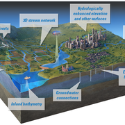
3D National Topography Model
The 3D National Topography Model (3DNTM) is a new initiative that updates, improves, and integrates USGS elevation and hydrography data to support the most demanding scientific requirements and enable data-driven decisions across user communities.

Conferences and Trade Shows
The USGS Conference and Trade Show sponsorship and exhibit booth program connects the scientific community with essential data, groundbreaking research, and innovative tools powered by USGS science and recruits the next generation of USGS leaders.