
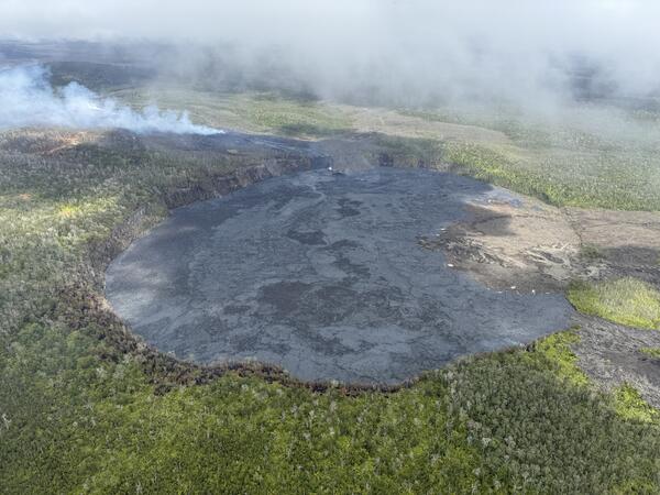
This image, captured during a UGSS Hawaiian Volcano Observatory monitoring overflight the morning of September 20, 2024, shows that most of Nāpau Crater floor has been covered with new lava during the recent Kīlauea middle East Rift Zone eruption. USGS photo by M. Patrick.
Images
Kīlauea images of eruptive activity, field work, and more.
Filter Total Items: 2294
September 20, 2024—Kīlauea middle East Rift Zone eruption overview
This image, captured during a UGSS Hawaiian Volcano Observatory monitoring overflight the morning of September 20, 2024, shows that most of Nāpau Crater floor has been covered with new lava during the recent Kīlauea middle East Rift Zone eruption. USGS photo by M. Patrick.

September 20, 2024—Kīlauea middle East Rift Zone eruption aerial view of fuming vent
USGS Hawaiian Volcano Observatory field monitoring crews reported minor spattering and small fountains at one end of the vent as of 8:30 a.m. HST on September 20, 2024. By 10 a.m. HST, eruptive activity had paused but the eruptive vents continued to emit volcanic gas and steam, visible in this aerial photograph.
USGS Hawaiian Volcano Observatory field monitoring crews reported minor spattering and small fountains at one end of the vent as of 8:30 a.m. HST on September 20, 2024. By 10 a.m. HST, eruptive activity had paused but the eruptive vents continued to emit volcanic gas and steam, visible in this aerial photograph.

September 20, 2024—Kīlauea middle East Rift Zone eruption spatter
USGS Hawaiian Volcano Observatory field crews reported small fountains and lava flows erupting from one of the western fissures just before 9 a.m. HST on September 20, 2024. By 10 a.m. HST, that activity had ceased and the middle East Rift Zone eruption of Kīlauea had paused. USGS photo by M. Patrick.
USGS Hawaiian Volcano Observatory field crews reported small fountains and lava flows erupting from one of the western fissures just before 9 a.m. HST on September 20, 2024. By 10 a.m. HST, that activity had ceased and the middle East Rift Zone eruption of Kīlauea had paused. USGS photo by M. Patrick.

September 20, 2024—Kīlauea middle East Rift Zone recent lava flows
Pāhoehoe lava flows paved the floor of Nāpau Crater during the recent eruption on Kīlauea middle East Rift Zone. Pāhoehoe is characterized by smooth, billowy, and ropy surface textures. Recent lava flowed over tephra that previously coated this area of the crater floor.
Pāhoehoe lava flows paved the floor of Nāpau Crater during the recent eruption on Kīlauea middle East Rift Zone. Pāhoehoe is characterized by smooth, billowy, and ropy surface textures. Recent lava flowed over tephra that previously coated this area of the crater floor.

September 20, 2024—Lava flows from recent Kīlauea middle East Rift Zone eruption cover Nāpau Trail
linkFrom the floor of Nāpau Crater, USGS Hawaiian Volcano Observatory geologists observed where recent lava flows covered the trail in the crater. The trail is visible in the lower center portion of the photograph, as a track in tephra deposited during previous eruptions in the area. USGS photo by M. Patrick.

September 20, 2024—Lava flows on the floor of Nāpau Crater, Kīlauea middle East Rift Zone
A view across the floor of Nāpau Crater, covered with fresh lava flows. In the background of the photo, which faces northwest, lava flows that recently cascaded over the northwest wall of the crater are visible. USGS photo by M. Patrick.
A view across the floor of Nāpau Crater, covered with fresh lava flows. In the background of the photo, which faces northwest, lava flows that recently cascaded over the northwest wall of the crater are visible. USGS photo by M. Patrick.

September 20, 2024—Ground cracks in the middle East Rift Zone of Kīlauea
On September 20, 2024, USGS Hawaiian Volcano Observatory geologists examined a ground crack near the recent eruption site in the remote middle East Rift Zone of Kīlauea. USGS photo by M. Patrick.
On September 20, 2024, USGS Hawaiian Volcano Observatory geologists examined a ground crack near the recent eruption site in the remote middle East Rift Zone of Kīlauea. USGS photo by M. Patrick.

September 20, 2024—Kīlauea middle East Rift Zone eruption overview
During the September 20 monitoring overflight, USGS Hawaiin Volcano Observatory geologists observed the fissure west of Nāpau Crater reactivate briefly between 8–9:30 a.m. HST, with minor fissure fountaining and lava flows. View is looking southeast. USGS photo by H. Winslow.
During the September 20 monitoring overflight, USGS Hawaiin Volcano Observatory geologists observed the fissure west of Nāpau Crater reactivate briefly between 8–9:30 a.m. HST, with minor fissure fountaining and lava flows. View is looking southeast. USGS photo by H. Winslow.

September 20, 2024—Kīlauea middle East Rift Zone eruption western fissure reactivation
A telephoto view of the fissure that briefly reactivated west of Nāpau Crater this morning, September 20. Low-level fountaining occurred from approximately 8–9:30 a.m. HST. USGS photo by H. Winslow.
A telephoto view of the fissure that briefly reactivated west of Nāpau Crater this morning, September 20. Low-level fountaining occurred from approximately 8–9:30 a.m. HST. USGS photo by H. Winslow.

September 20, 2024—Kīlauea middle East Rift Zone new lava
A glowing crack in a fresh lava flow on the floor of Nāpau Crater, on the middle East Rift Zone of Kīlauea. USGS photo by M. Patrick.
A glowing crack in a fresh lava flow on the floor of Nāpau Crater, on the middle East Rift Zone of Kīlauea. USGS photo by M. Patrick.

September 20, 2024 — Thermal map of eruption on Kīlauea East Rift Zone
A helicopter overflight on September 20, 2024, allowed for aerial visual and thermal imagery to be collected at the middle East Rift Zone eruption site on Kīlauea. This thermal map shows that the eruption at Nāpau Crater had paused this morning, with no fountaining or active lava on the surface.
A helicopter overflight on September 20, 2024, allowed for aerial visual and thermal imagery to be collected at the middle East Rift Zone eruption site on Kīlauea. This thermal map shows that the eruption at Nāpau Crater had paused this morning, with no fountaining or active lava on the surface.

September 19, 2024 —Kīlauea middle East Rift Zone eruption overflight
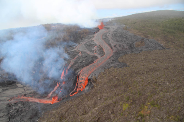
USGS Hawaiian Volcano Observatory geologists conducted a reconnaissance overflight of the eruption near Nāpau Crater on the middle East Rift Zone of Kīlauea. They observed a 150-m-long (nearly 500 feet) fissure west of the crater erupting lava that is flowing in the crater via a channel more than 50 meters (about 164 feet) wide.
USGS Hawaiian Volcano Observatory geologists conducted a reconnaissance overflight of the eruption near Nāpau Crater on the middle East Rift Zone of Kīlauea. They observed a 150-m-long (nearly 500 feet) fissure west of the crater erupting lava that is flowing in the crater via a channel more than 50 meters (about 164 feet) wide.
September 19, 2024 —Kīlauea middle East Rift Zone eruption overflight
USGS Hawaiian Volcano Observatory geologists conducted a reconnaissance overflight of the eruption near Nāpau Crater on the middle East Rift Zone of Kīlauea. They observed lava cascading over the rim of the crater from a channel more than 50 meters (about 164 feet) wide. Lava is contained within Nāpau Crater and now covers about two thirds of the crater floor.
USGS Hawaiian Volcano Observatory geologists conducted a reconnaissance overflight of the eruption near Nāpau Crater on the middle East Rift Zone of Kīlauea. They observed lava cascading over the rim of the crater from a channel more than 50 meters (about 164 feet) wide. Lava is contained within Nāpau Crater and now covers about two thirds of the crater floor.

September 19, 2024 —Kīlauea middle East Rift Zone eruption overflight
The 150-m-long (nearly 500 feet) fissure erupting west of Nāpau Crater within Hawaʻi Volcanoes National Park began erupting yesterday, September 18, around 3:15 p.m. It's part of an eruptive sequence that began in this area the night of September 15, 2024.
The 150-m-long (nearly 500 feet) fissure erupting west of Nāpau Crater within Hawaʻi Volcanoes National Park began erupting yesterday, September 18, around 3:15 p.m. It's part of an eruptive sequence that began in this area the night of September 15, 2024.

September 19, 2024 —Kīlauea middle East Rift Zone eruption aerial views
USGS Hawaiian Volcano Observatory geologists conducted a reconnaissance overflight of the eruption near Nāpau Crater on the middle East Rift Zone of Kīlauea. They observed a 150-m-long (nearly 500 feet) fissure west of the crater erupting lava that is flowing in the crater via a channel more than 50 meters (about 164 feet) wide.
USGS Hawaiian Volcano Observatory geologists conducted a reconnaissance overflight of the eruption near Nāpau Crater on the middle East Rift Zone of Kīlauea. They observed a 150-m-long (nearly 500 feet) fissure west of the crater erupting lava that is flowing in the crater via a channel more than 50 meters (about 164 feet) wide.

September 19, 2024 — Thermal map of eruption on Kīlauea East Rift Zone
A helicopter overflight on September 19, 2024, allowed for aerial visual and thermal imagery to be collected at the middle East Rift Zone eruption site on Kīlauea. The eruptive activity continues with a fissure vent active west of Nāpau Crater generating lava flows northeast into the crater.
A helicopter overflight on September 19, 2024, allowed for aerial visual and thermal imagery to be collected at the middle East Rift Zone eruption site on Kīlauea. The eruptive activity continues with a fissure vent active west of Nāpau Crater generating lava flows northeast into the crater.
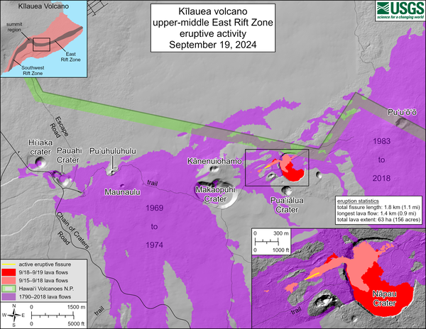
September 19, 2024 —Kīlauea middle East Rift Zone eruption reference map
This reference map depicts fissures and lava flows from the Kīlauea middle East Rift Zone eruption on Thursday, September 19, 2024. Map data are current as of the Hawaiian Volcano Observatory helicopter overflight that occurred between 9:00 and 10:00 a.m.
This reference map depicts fissures and lava flows from the Kīlauea middle East Rift Zone eruption on Thursday, September 19, 2024. Map data are current as of the Hawaiian Volcano Observatory helicopter overflight that occurred between 9:00 and 10:00 a.m.

September 19, 2024—New lava flows on the middle East Rift Zone of Kīlauea
On September 19, 2024, USGS-Hawaiian Volcano Observatory geologists landed near the Kīlauea middle East Rift Zone eruption site, where they viewed lava flowing through a channel more than 50 meters (about 164 feet) wide. USGS photo by M. Zoeller.
On September 19, 2024, USGS-Hawaiian Volcano Observatory geologists landed near the Kīlauea middle East Rift Zone eruption site, where they viewed lava flowing through a channel more than 50 meters (about 164 feet) wide. USGS photo by M. Zoeller.

September 19, 2024 —Kīlauea middle East Rift Zone eruption overflight
During the USGS Hawaiian Volcano Observatory reconnaissance overflight the morning of September 19, geologists observed the fissure west of Nāpau Crater generating a lava flow that travels northeast before cascading into the crater on the remote middle East Rift Zone of Kīlauea. This aerial view is looking in a south direction, from north of the eruption site.
During the USGS Hawaiian Volcano Observatory reconnaissance overflight the morning of September 19, geologists observed the fissure west of Nāpau Crater generating a lava flow that travels northeast before cascading into the crater on the remote middle East Rift Zone of Kīlauea. This aerial view is looking in a south direction, from north of the eruption site.

September 18, 2024 —Kīlauea middle East Rift Zone eruption
During a USGS Hawaiian Volcano Observatory monitoring overflight the morning of September 18, geologists observed only very weak activity at Kīlauea's middle East Rift Zone eruption site in Nāpau Crater.
During a USGS Hawaiian Volcano Observatory monitoring overflight the morning of September 18, geologists observed only very weak activity at Kīlauea's middle East Rift Zone eruption site in Nāpau Crater.