


During an overflight at 2:30 p.m. HST today, December 23, USGS Hawaiian Volcano Observatory scientists were able to collect a molten sample of lava from the new eruption within Kaluapele. Kaluapele, the summit caldera of Kīlauea volcano, is the sacred home of the elemental force associated with volcanoes—Pele.
Read answers to Frequently-Asked-Questions about eruptions at the summit of Kīlauea
Eruptive activity at the summit of Kīlauea, within Hawaiʻi Volcanoes National Park, has been intermittent since an eruption began on December 23, 2024.
Kīlauea is in a unique phase of activity in Halemaʻumaʻu, with numerous episodes of dual lava fountains since the eruption began the night of December 23, 2024. Two eruptive vents are located in the southwest part of the caldera, referred to as the north and south vent, and they have been intermittently active, producing new lava flows over parts of Halemaʻumaʻu crater surface.
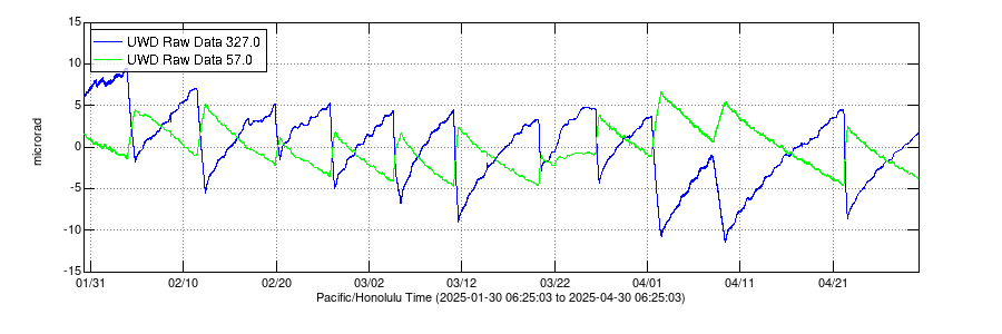
During the ongoing eruption, tiltmeters have shown inflationary tilt prior to a lava fountaining episode, as pressure builds beneath the surface, and a switch to deflationary tilt when a lava fountain episode begins, indicative of the pressure within the magma chambers being released. The switch to deflationary tilt generally defines an episode start.
This pattern of inflation and deflation with every recent lava fountain episode creates a saw-tooth pattern in ground tilt records over the past several months (see the plot below); however, Kīlauea summit has shown little net change in pressurization since the eruption began on December 23, 2024. This indicates that Kīlauea summit has been in some level of equilibrium since the eruption began. The north and south eruptive vents in Halemaʻumaʻu are able to incrementally release the pressure that accumulates within Kīlauea summit magma chambers with each eruptive episode.
Electronic Tilt at Kīlauea Summit and East Rift Zone - Past Three Months
Media
Remote image Url
Sources/Usage: Public Domain. View Media Details
Timeline of Eruptive Episodes
All times in the table below are Hawaiian Standard Time (HST).
| Episode Number | Start Date/Time (HST) | Pause Date/Time (HST) | Eruptive Episode Duration | Pause Duration Following Episode |
| 1 | December 23, 2024 - 2:20 a.m. | December 23, 2024 - 4 p.m. | 14 hours | 16 hours |
| 2 | December 24, 2024 - 8 a.m. | December 25, 2024 - 11 a.m. | 27 hours | 1 day |
| 3 | December 26, 2024 - 8 a.m. | January 3, 2025 - 8:30 p.m. | 8.5 days | 12 days |
| 4 | January 15, 2025 - 9 a.m. | January 18, 2025 - 10:10 a.m. | 3 days | 4 days |
| 5 | January 22, 2025 - 2:30 p.m. | January 23, 2025 - 4:30 a.m. | 14 hours | 2 days |
| 6 | January 24, 2025 - 11:28 p.m. | January 25, 2025 - 12:36 p.m. | 13 hours | 2 days |
| 7 | January 27, 2025 - 6:41 p.m. | January 28, 2025 - 10:41 a.m. | 16 hours | 6 days |
| 8 | February 3, 2025 - 9:52 p.m. | February 4, 2025 - 7:23 p.m. | 22 hours | 6 days |
| 9 | February 11, 2025 - 10:16 a.m. | February 12, 2025 - 8:43 a.m. | 22 hours | 7 days |
| 10 | February 19, 2025 - 8:22 p.m. | February 20, 2025 - 9:18 a.m. | 13 hours | 5 days |
| 11 | February 25, 2025 - 6:26 p.m. | February 26, 2025 - 7:06 a.m. | 13 hours | 6 days |
| 12 | March 4, 2025 - 7:30 a.m. | March 5, 2025 - 10:37 a.m. | 27 hours | 6 days |
| 13 | March 11, 2025 - 2:36 a.m. | March 11, 2025 - 3:13 p.m. | 13 hours | 8 days |
| 14 | March 19, 2025 - 9:26 a.m. | March 20, 2025 - 1:49 p.m. | 28 hours | 5 days |
| 15 | March 25, 2025 - 12:04 p.m. | March 26, 2025 - 7:10 p.m. | 31 hours | 5 days |
| 16 | March 31, 2025 - 10:57 p.m. | April 2, 2025 - 12:04 p.m. | 37 hours | 7 days |
| 17 | April 7, 2025 - 10:15 p.m. | April 9, 2025 - 9:45 a.m. | 35.5 hours | 9 days |
| 18 | April 16, 2025 - 10:01 p.m. (precursory low-level activity), April 22, 2025 - 3:30 a.m. (fountaining phase) | April 22, 2025 - 1:28 p.m. | 10 hours (fountaining phase) | 11 days |
| 19 | May 1, 2025 - 11:49 a.m. (precursory low-level activity) May 1, 2025 - 9:28 p.m. (fountaining phase) | May 2, 2025 - 5:20 a.m. | 8 hours (fountaining phase) | 3 days |
| 20 | May 5, 2024 - 10:48 a.m. (precursory low-level activity) May 6, 2025 - 5:28 p.m. (fountaining phase) | May 6, 2025 - 9:28 p.m. | 4.5 hours (fountaining phase) | 5 days |
| 21 | May 11, 2025 - 12:45 p.m. (fountaining phase) | May 11, 2025 - 8:36 p.m. | 8 hours (fountaining phase) | ongoing |
Latest eruption maps
Media

This reference map depicts the Kīlauea summit eruption within Halema‘uma‘u crater that began on December 23, 2024. As of this posting on April 30, 2025, the eruption has had eighteen episodes, with the most recent occurring on April 22. Most of the map data included here were collected during a Hawaiian Volcano Observatory helicopter overflight on April 29, so the provided statistics are reflective of the entire eruption to this point.
Sources/Usage: Public Domain. View Media Details
Media

This thermal map was taken on the 7 a.m. overflight of Kīlauea summit on April 9, 2025, and shows the expansive lava flow covering the floor of Halema‘uma‘u, supplied by lava fountains at the vent. As in earlier episodes, the lava exited the vent into a short channel that fed a broad perched lava pond. Lava channels then drained this pond and carried lava farther to the east. A small ooze-out, fed by lava supplied beneath the solidified crater floor, was present in the south portion of the crater. The fountaining ended a few hours after the flight, ending episode 17.
Sources/Usage: Public Domain. View Media Details
Additional Information
- Search for past volcano updates
- Subscribe to the USGS Volcano Notification Service to receive eruption updates
- Kīlauea geology and history
- Kīlauea Maps
- Vog Information Dashboard
- General Hawai‘i County Civil Defense information or subscribe to CD alerts and updates
- Follow USGS Volcanoes on Twitter, Facebook, and Instagram.
- Volcano viewing information from Hawaii Volcanoes National Park
Recent eruptions have taken place within Hawai‘i Volcanoes National Park. Please visit the Park website to learn more about their operations.

December 23, 2024 - Kīlauea summit eruption
This video, taken from the west rim of Kaluapele (Kīlauea caldera), in the closed area of Hawaiʻi Volcanoes National Park, shows the new eruption that started this morning at 2:20 a.m. HST. At approximately 4:30 a.m. HST, the lava fountains were reaching up to 80 meters (260 feet) and by 5:30 a.m., lava covered an area of approximately 400 acres on the caldera floor. USGS video by D. Downs.
Filter Total Items: 71

December 23, 2024 - Collecting a lava sample
During an overflight at 2:30 p.m. HST today, December 23, USGS Hawaiian Volcano Observatory scientists were able to collect a molten sample of lava from the new eruption within Kaluapele. Kaluapele, the summit caldera of Kīlauea volcano, is the sacred home of the elemental force associated with volcanoes—Pele.

December 23, 2024 - Preparing Kīlauea's newest eruption samples
Kīlauea's newest eruption samples contain olivine - a common green mineral in Hawaiian lavas. USGS Hawaiian Volcano Observatory and University of Hawai‘i at Hilo staff are picking out the olivine crystals like this one, shown using a microscope to magnify it (the crystal is 1 mm in size, or about 0.04 inches across), to analyze their chemistry.
Kīlauea's newest eruption samples contain olivine - a common green mineral in Hawaiian lavas. USGS Hawaiian Volcano Observatory and University of Hawai‘i at Hilo staff are picking out the olivine crystals like this one, shown using a microscope to magnify it (the crystal is 1 mm in size, or about 0.04 inches across), to analyze their chemistry.

December 23, 2024 - Analyzing Kīlauea's recent eruption samples
After sample preparation, University of Hawai‘i at Hilo faculty and an undergraduate research student load the most recent Kīlauea eruption sample into the ED-XRF (energy dispersive x-ray fluorescence) for chemical analysis. Within 6 hours of sample collection, the chemical analysis of the lava was completed. USGS photo by K. Lynn.
After sample preparation, University of Hawai‘i at Hilo faculty and an undergraduate research student load the most recent Kīlauea eruption sample into the ED-XRF (energy dispersive x-ray fluorescence) for chemical analysis. Within 6 hours of sample collection, the chemical analysis of the lava was completed. USGS photo by K. Lynn.

December 23, 2024—Kīlauea summit eruption reference map
This reference map depicts the new Kīlauea summit eruption within Halema‘uma‘u crater on December 23, 2024, constructed using data captured during a USGS Hawaiian Volcano Observatory helicopter overflight at 9:30 a.m.
This reference map depicts the new Kīlauea summit eruption within Halema‘uma‘u crater on December 23, 2024, constructed using data captured during a USGS Hawaiian Volcano Observatory helicopter overflight at 9:30 a.m.

December 23, 2024 — Thermal map of eruption at Kīlauea summit
This thermal map shows lava flows covering the floor of Halemaʻumaʻu crater at the summit of Kīlauea. Fountaining was active in the southwest portion of the caldera, with flows extending east onto the downdropped block. Cooler colors (purple, black) show lower temperatures while hotter colors (orange, yellow) show higher temperatures. USGS map by M.
This thermal map shows lava flows covering the floor of Halemaʻumaʻu crater at the summit of Kīlauea. Fountaining was active in the southwest portion of the caldera, with flows extending east onto the downdropped block. Cooler colors (purple, black) show lower temperatures while hotter colors (orange, yellow) show higher temperatures. USGS map by M.

December 23, 2024 - New eruption in Kīlauea summit caldera
Kīlauea volcano began erupting within the summit caldera at approximately 2:20 a.m. HST this morning, December 23, 2024, following an increase in seismicity that began beneath the summit just a half hour earlier, at approximately 2:00 a.m. HST.
Kīlauea volcano began erupting within the summit caldera at approximately 2:20 a.m. HST this morning, December 23, 2024, following an increase in seismicity that began beneath the summit just a half hour earlier, at approximately 2:00 a.m. HST.

December 23, 2024 - View of the new eruption at the summit of Kīlauea
This photograph, taken at approximately 4:00 a.m. HST from the Volcano House overlook in Hawaiʻi Volcanoes National Park, shows the new eruption within Kaluapele (the summit caldera).
This photograph, taken at approximately 4:00 a.m. HST from the Volcano House overlook in Hawaiʻi Volcanoes National Park, shows the new eruption within Kaluapele (the summit caldera).

December 23, 2024 - View from the west rim of Kaluapele
From the closed area of Hawaiʻi Volcanoes National Park, USGS Hawaiian Volcano Observatory geologists documented the new eruption within Kalupele that started this morning at 2:20 a.m. HST.
From the closed area of Hawaiʻi Volcanoes National Park, USGS Hawaiian Volcano Observatory geologists documented the new eruption within Kalupele that started this morning at 2:20 a.m. HST.
Eruptive activity at the summit of Kīlauea, within Hawaiʻi Volcanoes National Park, has been intermittent since an eruption began on December 23, 2024.
Kīlauea is in a unique phase of activity in Halemaʻumaʻu, with numerous episodes of dual lava fountains since the eruption began the night of December 23, 2024. Two eruptive vents are located in the southwest part of the caldera, referred to as the north and south vent, and they have been intermittently active, producing new lava flows over parts of Halemaʻumaʻu crater surface.
During the ongoing eruption, tiltmeters have shown inflationary tilt prior to a lava fountaining episode, as pressure builds beneath the surface, and a switch to deflationary tilt when a lava fountain episode begins, indicative of the pressure within the magma chambers being released. The switch to deflationary tilt generally defines an episode start.
This pattern of inflation and deflation with every recent lava fountain episode creates a saw-tooth pattern in ground tilt records over the past several months (see the plot below); however, Kīlauea summit has shown little net change in pressurization since the eruption began on December 23, 2024. This indicates that Kīlauea summit has been in some level of equilibrium since the eruption began. The north and south eruptive vents in Halemaʻumaʻu are able to incrementally release the pressure that accumulates within Kīlauea summit magma chambers with each eruptive episode.
Electronic Tilt at Kīlauea Summit and East Rift Zone - Past Three Months
Media
Remote image Url
Sources/Usage: Public Domain. View Media Details
Timeline of Eruptive Episodes
All times in the table below are Hawaiian Standard Time (HST).
| Episode Number | Start Date/Time (HST) | Pause Date/Time (HST) | Eruptive Episode Duration | Pause Duration Following Episode |
| 1 | December 23, 2024 - 2:20 a.m. | December 23, 2024 - 4 p.m. | 14 hours | 16 hours |
| 2 | December 24, 2024 - 8 a.m. | December 25, 2024 - 11 a.m. | 27 hours | 1 day |
| 3 | December 26, 2024 - 8 a.m. | January 3, 2025 - 8:30 p.m. | 8.5 days | 12 days |
| 4 | January 15, 2025 - 9 a.m. | January 18, 2025 - 10:10 a.m. | 3 days | 4 days |
| 5 | January 22, 2025 - 2:30 p.m. | January 23, 2025 - 4:30 a.m. | 14 hours | 2 days |
| 6 | January 24, 2025 - 11:28 p.m. | January 25, 2025 - 12:36 p.m. | 13 hours | 2 days |
| 7 | January 27, 2025 - 6:41 p.m. | January 28, 2025 - 10:41 a.m. | 16 hours | 6 days |
| 8 | February 3, 2025 - 9:52 p.m. | February 4, 2025 - 7:23 p.m. | 22 hours | 6 days |
| 9 | February 11, 2025 - 10:16 a.m. | February 12, 2025 - 8:43 a.m. | 22 hours | 7 days |
| 10 | February 19, 2025 - 8:22 p.m. | February 20, 2025 - 9:18 a.m. | 13 hours | 5 days |
| 11 | February 25, 2025 - 6:26 p.m. | February 26, 2025 - 7:06 a.m. | 13 hours | 6 days |
| 12 | March 4, 2025 - 7:30 a.m. | March 5, 2025 - 10:37 a.m. | 27 hours | 6 days |
| 13 | March 11, 2025 - 2:36 a.m. | March 11, 2025 - 3:13 p.m. | 13 hours | 8 days |
| 14 | March 19, 2025 - 9:26 a.m. | March 20, 2025 - 1:49 p.m. | 28 hours | 5 days |
| 15 | March 25, 2025 - 12:04 p.m. | March 26, 2025 - 7:10 p.m. | 31 hours | 5 days |
| 16 | March 31, 2025 - 10:57 p.m. | April 2, 2025 - 12:04 p.m. | 37 hours | 7 days |
| 17 | April 7, 2025 - 10:15 p.m. | April 9, 2025 - 9:45 a.m. | 35.5 hours | 9 days |
| 18 | April 16, 2025 - 10:01 p.m. (precursory low-level activity), April 22, 2025 - 3:30 a.m. (fountaining phase) | April 22, 2025 - 1:28 p.m. | 10 hours (fountaining phase) | 11 days |
| 19 | May 1, 2025 - 11:49 a.m. (precursory low-level activity) May 1, 2025 - 9:28 p.m. (fountaining phase) | May 2, 2025 - 5:20 a.m. | 8 hours (fountaining phase) | 3 days |
| 20 | May 5, 2024 - 10:48 a.m. (precursory low-level activity) May 6, 2025 - 5:28 p.m. (fountaining phase) | May 6, 2025 - 9:28 p.m. | 4.5 hours (fountaining phase) | 5 days |
| 21 | May 11, 2025 - 12:45 p.m. (fountaining phase) | May 11, 2025 - 8:36 p.m. | 8 hours (fountaining phase) | ongoing |
Latest eruption maps
Media
This reference map depicts the Kīlauea summit eruption within Halema‘uma‘u crater that began on December 23, 2024. As of this posting on April 30, 2025, the eruption has had eighteen episodes, with the most recent occurring on April 22. Most of the map data included here were collected during a Hawaiian Volcano Observatory helicopter overflight on April 29, so the provided statistics are reflective of the entire eruption to this point.
Sources/Usage: Public Domain. View Media Details
Media
This thermal map was taken on the 7 a.m. overflight of Kīlauea summit on April 9, 2025, and shows the expansive lava flow covering the floor of Halema‘uma‘u, supplied by lava fountains at the vent. As in earlier episodes, the lava exited the vent into a short channel that fed a broad perched lava pond. Lava channels then drained this pond and carried lava farther to the east. A small ooze-out, fed by lava supplied beneath the solidified crater floor, was present in the south portion of the crater. The fountaining ended a few hours after the flight, ending episode 17.
Sources/Usage: Public Domain. View Media Details
Additional Information
- Search for past volcano updates
- Subscribe to the USGS Volcano Notification Service to receive eruption updates
- Kīlauea geology and history
- Kīlauea Maps
- Vog Information Dashboard
- General Hawai‘i County Civil Defense information or subscribe to CD alerts and updates
- Follow USGS Volcanoes on Twitter, Facebook, and Instagram.
- Volcano viewing information from Hawaii Volcanoes National Park
Recent eruptions have taken place within Hawai‘i Volcanoes National Park. Please visit the Park website to learn more about their operations.
December 23, 2024 - Kīlauea summit eruption
This video, taken from the west rim of Kaluapele (Kīlauea caldera), in the closed area of Hawaiʻi Volcanoes National Park, shows the new eruption that started this morning at 2:20 a.m. HST. At approximately 4:30 a.m. HST, the lava fountains were reaching up to 80 meters (260 feet) and by 5:30 a.m., lava covered an area of approximately 400 acres on the caldera floor. USGS video by D. Downs.
Filter Total Items: 71
December 23, 2024 - Collecting a lava sample
During an overflight at 2:30 p.m. HST today, December 23, USGS Hawaiian Volcano Observatory scientists were able to collect a molten sample of lava from the new eruption within Kaluapele. Kaluapele, the summit caldera of Kīlauea volcano, is the sacred home of the elemental force associated with volcanoes—Pele.
During an overflight at 2:30 p.m. HST today, December 23, USGS Hawaiian Volcano Observatory scientists were able to collect a molten sample of lava from the new eruption within Kaluapele. Kaluapele, the summit caldera of Kīlauea volcano, is the sacred home of the elemental force associated with volcanoes—Pele.
December 23, 2024 - Preparing Kīlauea's newest eruption samples
Kīlauea's newest eruption samples contain olivine - a common green mineral in Hawaiian lavas. USGS Hawaiian Volcano Observatory and University of Hawai‘i at Hilo staff are picking out the olivine crystals like this one, shown using a microscope to magnify it (the crystal is 1 mm in size, or about 0.04 inches across), to analyze their chemistry.
Kīlauea's newest eruption samples contain olivine - a common green mineral in Hawaiian lavas. USGS Hawaiian Volcano Observatory and University of Hawai‘i at Hilo staff are picking out the olivine crystals like this one, shown using a microscope to magnify it (the crystal is 1 mm in size, or about 0.04 inches across), to analyze their chemistry.
December 23, 2024 - Analyzing Kīlauea's recent eruption samples
After sample preparation, University of Hawai‘i at Hilo faculty and an undergraduate research student load the most recent Kīlauea eruption sample into the ED-XRF (energy dispersive x-ray fluorescence) for chemical analysis. Within 6 hours of sample collection, the chemical analysis of the lava was completed. USGS photo by K. Lynn.
After sample preparation, University of Hawai‘i at Hilo faculty and an undergraduate research student load the most recent Kīlauea eruption sample into the ED-XRF (energy dispersive x-ray fluorescence) for chemical analysis. Within 6 hours of sample collection, the chemical analysis of the lava was completed. USGS photo by K. Lynn.
December 23, 2024—Kīlauea summit eruption reference map
This reference map depicts the new Kīlauea summit eruption within Halema‘uma‘u crater on December 23, 2024, constructed using data captured during a USGS Hawaiian Volcano Observatory helicopter overflight at 9:30 a.m.
This reference map depicts the new Kīlauea summit eruption within Halema‘uma‘u crater on December 23, 2024, constructed using data captured during a USGS Hawaiian Volcano Observatory helicopter overflight at 9:30 a.m.
December 23, 2024 — Thermal map of eruption at Kīlauea summit
This thermal map shows lava flows covering the floor of Halemaʻumaʻu crater at the summit of Kīlauea. Fountaining was active in the southwest portion of the caldera, with flows extending east onto the downdropped block. Cooler colors (purple, black) show lower temperatures while hotter colors (orange, yellow) show higher temperatures. USGS map by M.
This thermal map shows lava flows covering the floor of Halemaʻumaʻu crater at the summit of Kīlauea. Fountaining was active in the southwest portion of the caldera, with flows extending east onto the downdropped block. Cooler colors (purple, black) show lower temperatures while hotter colors (orange, yellow) show higher temperatures. USGS map by M.
December 23, 2024 - New eruption in Kīlauea summit caldera
Kīlauea volcano began erupting within the summit caldera at approximately 2:20 a.m. HST this morning, December 23, 2024, following an increase in seismicity that began beneath the summit just a half hour earlier, at approximately 2:00 a.m. HST.
Kīlauea volcano began erupting within the summit caldera at approximately 2:20 a.m. HST this morning, December 23, 2024, following an increase in seismicity that began beneath the summit just a half hour earlier, at approximately 2:00 a.m. HST.
December 23, 2024 - View of the new eruption at the summit of Kīlauea
This photograph, taken at approximately 4:00 a.m. HST from the Volcano House overlook in Hawaiʻi Volcanoes National Park, shows the new eruption within Kaluapele (the summit caldera).
This photograph, taken at approximately 4:00 a.m. HST from the Volcano House overlook in Hawaiʻi Volcanoes National Park, shows the new eruption within Kaluapele (the summit caldera).
December 23, 2024 - View from the west rim of Kaluapele
From the closed area of Hawaiʻi Volcanoes National Park, USGS Hawaiian Volcano Observatory geologists documented the new eruption within Kalupele that started this morning at 2:20 a.m. HST.
From the closed area of Hawaiʻi Volcanoes National Park, USGS Hawaiian Volcano Observatory geologists documented the new eruption within Kalupele that started this morning at 2:20 a.m. HST.