
Clear weather during a Kīlauea summit monitoring overflight allowed for views of Mauna Kea in the distance, with the slope of Mauna Loa's Northeast Rift Zone visible on the left side of the image. Small amounts of snow from a recent storm remain visible on the slopes of Mauna Kea. USGS photo by P. Dotray.
Images
Mauna Kea images.
Filter Total Items: 23

February 12, 2025 — Views of Mauna Kea during Kīlauea summit overflight
Clear weather during a Kīlauea summit monitoring overflight allowed for views of Mauna Kea in the distance, with the slope of Mauna Loa's Northeast Rift Zone visible on the left side of the image. Small amounts of snow from a recent storm remain visible on the slopes of Mauna Kea. USGS photo by P. Dotray.

February 3, 2025 — Snow on Mauna Kea
With quite clear conditions on the morning of February 3, 2025, USGS Hawaiian Volcano Observatory crews on a monitoring overflight of Kīlauea summit had excellent views of the snow-capped Mauna Kea (shown here) and Mauna Loa. Both mountain summits received snow during a winter storm that passed over the Island of Hawai‘i last week. USGS photo by K. Lynn.
With quite clear conditions on the morning of February 3, 2025, USGS Hawaiian Volcano Observatory crews on a monitoring overflight of Kīlauea summit had excellent views of the snow-capped Mauna Kea (shown here) and Mauna Loa. Both mountain summits received snow during a winter storm that passed over the Island of Hawai‘i last week. USGS photo by K. Lynn.

Map of volcanoes and infrastructure on the Island of Hawaiʻi
Map of Island of Hawaiʻi, highlighting the four active or potentially active volcanoes of the Island, the number of people living on each volcano based on 2020 census data, major roads (transportation corridors) and minor roads (proxy for population density), when each volcano last erupted, and each volcano’s national threat assessment designation.
Map of Island of Hawaiʻi, highlighting the four active or potentially active volcanoes of the Island, the number of people living on each volcano based on 2020 census data, major roads (transportation corridors) and minor roads (proxy for population density), when each volcano last erupted, and each volcano’s national threat assessment designation.

Kīlauea caldera wall and Mauna Kea—July 19, 2022
Aerial view of the north wall of Kīlauea caldera. The bright green area near the center of the image is the Volcano Golf Course. Between it and the caldera edge is the Kīlauea Military Camp. Mauna Kea rises beyond the slopes of the Northeast Rift Zone of Mauna Loa in the background. USGS image by J. Chang.
Aerial view of the north wall of Kīlauea caldera. The bright green area near the center of the image is the Volcano Golf Course. Between it and the caldera edge is the Kīlauea Military Camp. Mauna Kea rises beyond the slopes of the Northeast Rift Zone of Mauna Loa in the background. USGS image by J. Chang.

Island of Hawai‘i seismicity
Two weeks of earthquake activity preceding the September 29, 2021, eruption at Kīlauea summit. The regions of interest indicated on the map include: KS (Kīlauea summit); ML (Mauna Loa summit); P (Pāhala).
Two weeks of earthquake activity preceding the September 29, 2021, eruption at Kīlauea summit. The regions of interest indicated on the map include: KS (Kīlauea summit); ML (Mauna Loa summit); P (Pāhala).

How measuring gravity on Mauna Kea helps us monitor Mauna Loa
A gravimeter measuring the force of gravity on Mauna Kea. These measurements are used to calibrate the instruments so they can precisely monitor changes in gravity from magma accumulation at Mauna Loa (background). USGS photograph taken on December 10, 2020.
A gravimeter measuring the force of gravity on Mauna Kea. These measurements are used to calibrate the instruments so they can precisely monitor changes in gravity from magma accumulation at Mauna Loa (background). USGS photograph taken on December 10, 2020.

Example 2-hours of seismic data from station near Mauna Kea
Example 2-hours of seismic data from station near Mauna Kea on April 14, 2020. The large spikes are earthquakes under Mauna Kea repeating every ~11 minutes. Bottom waveform zooms in on 15 seconds of an individual event.
Example 2-hours of seismic data from station near Mauna Kea on April 14, 2020. The large spikes are earthquakes under Mauna Kea repeating every ~11 minutes. Bottom waveform zooms in on 15 seconds of an individual event.

The gentle slope of Mauna Loa as seen from the flanks of Mauna Kea ...
The gentle slope of Mauna Loa as seen from the flanks of Mauna Kea to the north. Younger lava flows appear dark on the volcano's flank, and clouds rest in the eastern saddle between the two volcanoes.
The gentle slope of Mauna Loa as seen from the flanks of Mauna Kea to the north. Younger lava flows appear dark on the volcano's flank, and clouds rest in the eastern saddle between the two volcanoes.

panoramic view of the 1935 Humu‘ula flow
This panoramic view of the 1935 Humu‘ula flow (black lava) on both sides of the Daniel K. Inouye Highway, which runs east to west in the saddle between Mauna Loa (snow-capped shield volcano at far left) and Mauna Kea (distant right), was taken from the top of Pu‘uhuluhulu. View is to the northwest. The top of Hualālai is visible in far distance (center).
This panoramic view of the 1935 Humu‘ula flow (black lava) on both sides of the Daniel K. Inouye Highway, which runs east to west in the saddle between Mauna Loa (snow-capped shield volcano at far left) and Mauna Kea (distant right), was taken from the top of Pu‘uhuluhulu. View is to the northwest. The top of Hualālai is visible in far distance (center).

Sunset on Mauna Kea
Research projects with the USGS take scientists to beautiful places and Mauna Kea volcano on Hawai‘i Island is no exception. Here is a palila field crew camping site on the north slope of Mauna Kea as the sun sets.
Research projects with the USGS take scientists to beautiful places and Mauna Kea volcano on Hawai‘i Island is no exception. Here is a palila field crew camping site on the north slope of Mauna Kea as the sun sets.

Mar 7, 2014: lava pond in Pu‘u ‘Ō‘ō, with snow-covered Mauna Kea in...
Mar 7, 2014: A close-up of the lava pond in Pu‘u ‘Ō‘ō crater, with snow-covered Mauna Kea in the distance.
Mar 7, 2014: A close-up of the lava pond in Pu‘u ‘Ō‘ō crater, with snow-covered Mauna Kea in the distance.

Shield-volcano Mauna Kea viewed from the northern slope of Mauna Lo...
Shield-volcano Mauna Kea viewed from the northern slope of Mauna Loa (cinder cones in the foreground) shows off its broad shield shape. The bumps on its profile are large cinder cones.
Shield-volcano Mauna Kea viewed from the northern slope of Mauna Loa (cinder cones in the foreground) shows off its broad shield shape. The bumps on its profile are large cinder cones.

Mauna Loa looking across an unnamed cone toward Mauna Kea
View from above Mauna Loa's upper Northeast Rift Zone looking across an unnamed cone toward Mauna Kea.
View from above Mauna Loa's upper Northeast Rift Zone looking across an unnamed cone toward Mauna Kea.

US Army helicopter flies over the heads of researchers on Mauna Kea
A US Army helicopter from Pohakuloa Training Area flies overhead of palila researchers on Mauna Kea volcano, Hawai‘i Island, Hawai‘i.
A US Army helicopter from Pohakuloa Training Area flies overhead of palila researchers on Mauna Kea volcano, Hawai‘i Island, Hawai‘i.

Radio telemetry tower on Mauna Kea
A VHF radio receiving tower is set up on the slopes of Mauna Kea volcano on Hawai‘i Island, Hawai‘i. This setup allowed researchers to track radio tagged palila over large areas to determine where they were spending their time.
A VHF radio receiving tower is set up on the slopes of Mauna Kea volcano on Hawai‘i Island, Hawai‘i. This setup allowed researchers to track radio tagged palila over large areas to determine where they were spending their time.

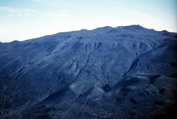
Profile of Mauna Kea showing inferred contact (dot-dashed line) bet...
Profile of Mauna Kea showing inferred contact (dot-dashed line) between postshield-stage Hamakua Volcanics and underlying shield-stage lavas. Approximate contact with Laupahoehoe Volcanics dashed.
Profile of Mauna Kea showing inferred contact (dot-dashed line) between postshield-stage Hamakua Volcanics and underlying shield-stage lavas. Approximate contact with Laupahoehoe Volcanics dashed.
Geologic map of Mauna Kea with generalized surface distribution of ...
Geologic map of Mauna Kea with generalized surface distribution of Hamakua Volcanics. Laupahoehoe Volcanics are inferred to overlie a vast area of Hamakua Volcanics on the upper flanks and summit.
Geologic map of Mauna Kea with generalized surface distribution of Hamakua Volcanics. Laupahoehoe Volcanics are inferred to overlie a vast area of Hamakua Volcanics on the upper flanks and summit.

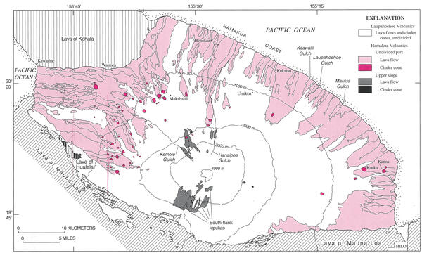
Geologic map of Mauna Kea, showing generalized distribution of lava...
Geologic map of Mauna Kea, showing generalized distribution of lava flows, cinder cones, and glacial deposits of the Laupahoehoe Volcanics.
Geologic map of Mauna Kea, showing generalized distribution of lava flows, cinder cones, and glacial deposits of the Laupahoehoe Volcanics.

Cinder Cones on Mauna Kea
Cinder cones at the summit of Mauna Kea. Mauna Kea is a dormant shield volcano on the north end of Hawaii Island. Astronomical observatories in the foreground.
Cinder cones at the summit of Mauna Kea. Mauna Kea is a dormant shield volcano on the north end of Hawaii Island. Astronomical observatories in the foreground.
Glacial end moraine deposits on south flank of Mauna Kea, Hawai‘i
Glacial end moraine deposits on south flank of Mauna Kea, Hawai‘i
Glacial end moraine deposits on south flank of Mauna Kea, Hawai‘i

Pu‘umaKAHAKOkanaka, NE flank of Mauna Kea, Hawai‘i
12,398 ft elev according to USGS Geographic Names Information System
12,398 ft elev according to USGS Geographic Names Information System