
Unvegetated Big Obsidian Flow about 500 m (1640 ft) below people. Central Pumice Cone separates East Lake (distant) and Paulina Lake.
Images
Images related to Newberry.

View from Paulina Peak on south rim of Newberry caldera
Unvegetated Big Obsidian Flow about 500 m (1640 ft) below people. Central Pumice Cone separates East Lake (distant) and Paulina Lake.

A MultiGAS instrument measures gases at Newberry Volcano
Scientists use a MultiGAS instrument (gray, hard-shell case) to measure gas compositions from the East Lake hot spring in the Newberry caldera. The photo was taken on August 3, 2020 just after sunrise. The vapor above the hot spring and lake is typical for cool mornings and is not visible later in the day.
Scientists use a MultiGAS instrument (gray, hard-shell case) to measure gas compositions from the East Lake hot spring in the Newberry caldera. The photo was taken on August 3, 2020 just after sunrise. The vapor above the hot spring and lake is typical for cool mornings and is not visible later in the day.

Digital Elevation Model for Newberry Volcano and vicinity.
High-resolution digital elevation dataset for Newberry Volcano and vicinity, Oregon, based on lidar survey of August-September, 2010 and bathymetric survey of June, 2001.
High-resolution digital elevation dataset for Newberry Volcano and vicinity, Oregon, based on lidar survey of August-September, 2010 and bathymetric survey of June, 2001.

Paulina Lake, in the caldera of Newberry Volcano. Photographed fro...
Paulina Lake, in the caldera of Newberry Volcano. View looking south-southeast.
Paulina Lake, in the caldera of Newberry Volcano. View looking south-southeast.

Newberry Volcano's Youngest Lava Flows
Newberry Volcano's youngest lava flows. Source: Robinson, J.E., Donnelly-Nolan, J.M., and Jensen, R.A., 2015, Newberry Volcano’s Youngest Lava Flows: U.S. Geological Survey Scientific Investigations Map 3329, 1 sheet, https://dx.doi.org/10.3133/sim3329.
Newberry Volcano's youngest lava flows. Source: Robinson, J.E., Donnelly-Nolan, J.M., and Jensen, R.A., 2015, Newberry Volcano’s Youngest Lava Flows: U.S. Geological Survey Scientific Investigations Map 3329, 1 sheet, https://dx.doi.org/10.3133/sim3329.

Newberry Volcano, OR simplified hazards map
Newberry Volcano, Oregon simplified hazards map showing potential impact area for ground-based hazards during a volcanic event.
Newberry Volcano, Oregon simplified hazards map showing potential impact area for ground-based hazards during a volcanic event.

Map showing one-year probability of accumulation of 1 centimeter
Map showing one-year probability of accumulation of 1 centimeter (0.4 inch) or more of tephra from eruptions of volcanoes in the Cascade Range.
Map showing one-year probability of accumulation of 1 centimeter (0.4 inch) or more of tephra from eruptions of volcanoes in the Cascade Range.

Lake-Ice Quakes from Newberry Volcano
The popping and cracking of ice in lakes within the Newberry Volcano caldera is picked up by local seismic stations, such as Central Pumice Cone. The lake-ice quakes do not resemble standard volcanic low-frequency or high-frequency events and are sporadically observed in the winter at other ice-covered lakes in Yellowstone, Long Valley, and elsewhere.
The popping and cracking of ice in lakes within the Newberry Volcano caldera is picked up by local seismic stations, such as Central Pumice Cone. The lake-ice quakes do not resemble standard volcanic low-frequency or high-frequency events and are sporadically observed in the winter at other ice-covered lakes in Yellowstone, Long Valley, and elsewhere.

Extent of Newberry lavas including approximate ages of surficial flows
Extending approximately 75 miles north to south and 27 miles east to west, Newberry Volcano and its broad apron of lavas (light yellow shaded area) cover a total area of almost 1,200 square miles, making it the largest volcano of the Cascades volcanic chain. Its lavas stretch north beyond Smith Rock State Park, and south almost to Fort Rock State Natural Area.
Extending approximately 75 miles north to south and 27 miles east to west, Newberry Volcano and its broad apron of lavas (light yellow shaded area) cover a total area of almost 1,200 square miles, making it the largest volcano of the Cascades volcanic chain. Its lavas stretch north beyond Smith Rock State Park, and south almost to Fort Rock State Natural Area.
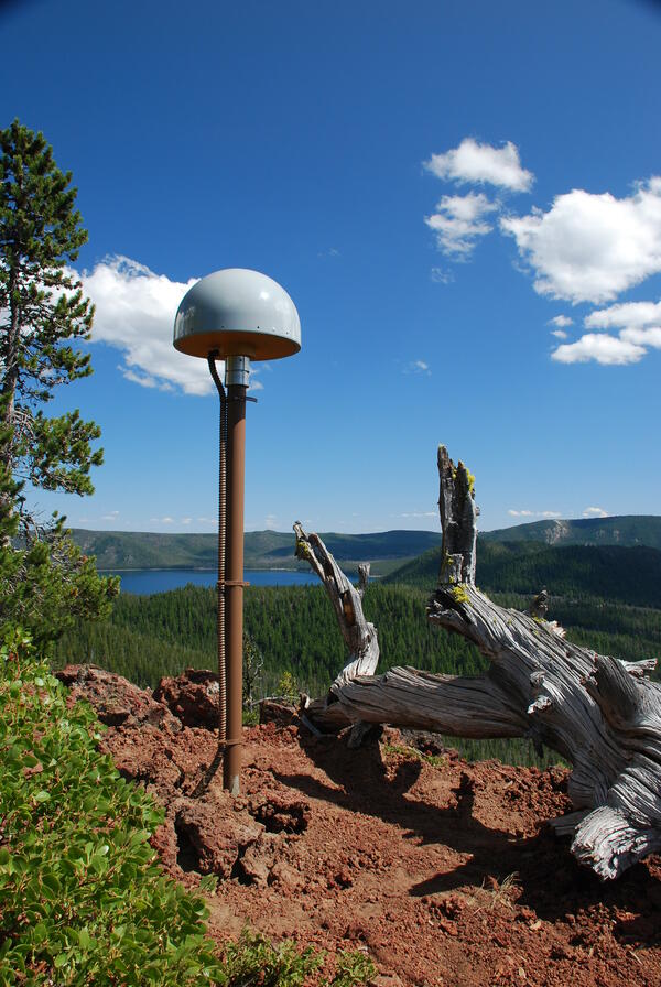
Global Positioning System receiver (called a GPS monument) at North...
Global Positioning System receiver (called a GPS monument) at North Rim Station, a monitoring location at Newberry volcano, Oregon.
Global Positioning System receiver (called a GPS monument) at North Rim Station, a monitoring location at Newberry volcano, Oregon.

Newberry caldera with Paulina Peak, Big Obsidian Flow and Paulina Lake
View looking south across Newberry caldera towards the Big Obsidian flow (left of center) and Paulina Peak, with Paulina Lake in foreground. Photo taken from the north rim of the caldera.
View looking south across Newberry caldera towards the Big Obsidian flow (left of center) and Paulina Peak, with Paulina Lake in foreground. Photo taken from the north rim of the caldera.
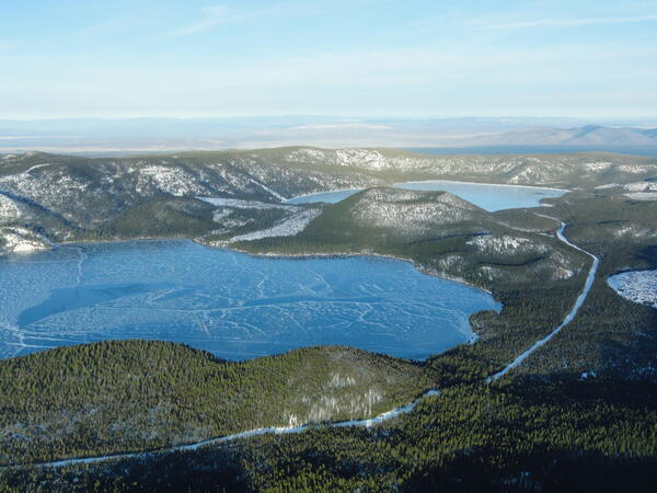
Aerial view of lakes and cinder cone at Newberry Volcano Caldera.
A view looking northeast across the central caldera of Newberry Volcano. Paulina Lake is in the foreground and East Lake is in the distance. The Central Pumice Cone lies between the two lakes. Near the bottom of the photo at the south edge of Paulina Lake, the two hills are named the Lakeshore Domes.
A view looking northeast across the central caldera of Newberry Volcano. Paulina Lake is in the foreground and East Lake is in the distance. The Central Pumice Cone lies between the two lakes. Near the bottom of the photo at the south edge of Paulina Lake, the two hills are named the Lakeshore Domes.

Eruptions in the Cascade Range during the past 4000 years. USGS GIP 64
Eruptions in the Cascade Range during the past 4000 years. USGS GIP 64
Eruptions in the Cascade Range during the past 4000 years. USGS GIP 64

Erratics located on a cinder cone about 5 km (3 mi) NE of Newberry
Erratics located on a cinder cone on the northeast flank of Newberry Volcano, Oregon.
Erratics located on a cinder cone on the northeast flank of Newberry Volcano, Oregon.