
A frantic-looking scene in northeastern Ethiopia shows the location of three tectonic plates shifting away from each other. In this region, Earth’s crust is rifting at 1 to 2 centimeters per year. New fissures opened in the Erta Ale shield volcano in January 2017, and this image from March 2017 shows the locations of the fresh lava.
Images
Peruse our selection of remote sensing and Earth science imagery below.
Filter Total Items: 774

Torn Apart
A frantic-looking scene in northeastern Ethiopia shows the location of three tectonic plates shifting away from each other. In this region, Earth’s crust is rifting at 1 to 2 centimeters per year. New fissures opened in the Erta Ale shield volcano in January 2017, and this image from March 2017 shows the locations of the fresh lava.

ISRO Resourcesat-2 image of Lake Pontchartrain, March 2017
This is an image acquired with the Linear Imaging Self-Scanning Sensor III on the Indian Space Research Organization's Resourcesat-2 satellite that is now available in the EROS Archive. It is the New Orleans/Lake Pontchartrain area and was acquired March 31, 2017.
This is an image acquired with the Linear Imaging Self-Scanning Sensor III on the Indian Space Research Organization's Resourcesat-2 satellite that is now available in the EROS Archive. It is the New Orleans/Lake Pontchartrain area and was acquired March 31, 2017.

Satellite Image of New Orleans Region
This image of the New Orleans/Lake Pontchartrain area in Louisiana was acquired March 31, 2017, from the Indian Space Research Organization’s Resourcesat-2 LISS-3 sensor. Land loss and hurricane hazards are key landscape issues here.
This image of the New Orleans/Lake Pontchartrain area in Louisiana was acquired March 31, 2017, from the Indian Space Research Organization’s Resourcesat-2 LISS-3 sensor. Land loss and hurricane hazards are key landscape issues here.

The Wildflower Superbloom in California from Landsat’s Perspective
After 5 years of drought, California finally got relief during the winter of 2016–2017 with much needed precipitation. One result of this additional moisture was a springtime abundance of wildflowers.
After 5 years of drought, California finally got relief during the winter of 2016–2017 with much needed precipitation. One result of this additional moisture was a springtime abundance of wildflowers.

California Wildflower Superbloom, Spring 2017, Landsat 8
After 5 years of drought, California finally got relief during the winter of 2016–2017 with much needed precipitation. One result of this additional moisture was a springtime abundance of wildflowers in 2017. This Landsat 8 image shows a large area of wildflower "superbloom" just north of Los Padres National Forest in southern California.
After 5 years of drought, California finally got relief during the winter of 2016–2017 with much needed precipitation. One result of this additional moisture was a springtime abundance of wildflowers in 2017. This Landsat 8 image shows a large area of wildflower "superbloom" just north of Los Padres National Forest in southern California.

Landsat Views Massive Solar Energy Farms
Solar energy is booming worldwide, and these Landsat 8 images show three large solar energy farms.
Solar energy is booming worldwide, and these Landsat 8 images show three large solar energy farms.

Outburst
Red and black seem to mar the icy glacial landscape of southern Iceland. The gray-black filaments are past glacial melting outbursts called jökulhlaups. These abrupt flooding events gush down this outwash plain called Skeiðarársandur, one of the world’s largest. The Skeiðarárjökull Glacier reaches down from the top left of the image.
Red and black seem to mar the icy glacial landscape of southern Iceland. The gray-black filaments are past glacial melting outbursts called jökulhlaups. These abrupt flooding events gush down this outwash plain called Skeiðarársandur, one of the world’s largest. The Skeiðarárjökull Glacier reaches down from the top left of the image.

Fires Burn Farms and Ranches in Oklahoma and Kansas
Landsat's shortwave infrared (SWIR) band measures reduced moisture content in soil and vegetation. When combined with its near-infrared (NIR) band, which helps reveal actively growing vegetation, Landsat produces highly accurate images and maps of burned areas.
Landsat's shortwave infrared (SWIR) band measures reduced moisture content in soil and vegetation. When combined with its near-infrared (NIR) band, which helps reveal actively growing vegetation, Landsat produces highly accurate images and maps of burned areas.

Bleeding Heart
A feathery, blood red streak cuts across the heart of this image. The translucent red paint stroke is not actually a feature of the land. It is a cirrus cloud detected by Landsat 8’s cirrus band. This cirrus cloud, which hovers over the Aral Sea in Kazakhstan, is invisible in natural color imagery.
A feathery, blood red streak cuts across the heart of this image. The translucent red paint stroke is not actually a feature of the land. It is a cirrus cloud detected by Landsat 8’s cirrus band. This cirrus cloud, which hovers over the Aral Sea in Kazakhstan, is invisible in natural color imagery.

March Wildfires Scorch Kansas, Oklahoma Farm and Ranch Land
This March 2017 Landsat 8 image shows massive burned scars in Kansas and Oklahoma. More than 730,000 acres of farm and ranchland were scorched by wind-driven wildfires that began March 6 and were finally extinguished on March 22.
This March 2017 Landsat 8 image shows massive burned scars in Kansas and Oklahoma. More than 730,000 acres of farm and ranchland were scorched by wind-driven wildfires that began March 6 and were finally extinguished on March 22.

Landsat Detects Eruptions at Ethiopian Volcano
Landsat 8’s shortwave infrared (SWIR) band is useful in viewing recent eruptions at Erta Ale volcano in northern Ethiopia near the Eritrea border.
Landsat 8’s shortwave infrared (SWIR) band is useful in viewing recent eruptions at Erta Ale volcano in northern Ethiopia near the Eritrea border.

Cambodia Experiences Rapid Rate of Forest Loss
Among countries with accelerated rates of deforestation—Sierra Leone, Madagascar, Uruguay, and Paraguay among them—Cambodia ranks above them all with an annual loss of 14.4 percent of its forests between 2001 and 2014, according to researchers at the University of Maryland, who used Landsat data to track their rates.
Among countries with accelerated rates of deforestation—Sierra Leone, Madagascar, Uruguay, and Paraguay among them—Cambodia ranks above them all with an annual loss of 14.4 percent of its forests between 2001 and 2014, according to researchers at the University of Maryland, who used Landsat data to track their rates.

Landsat 8 reveal glacial retreat in South America's Patagonia, 2017
Landsat satellites have helped document retreating glaciers worldwide. In this 2017 Landsat 8 image, glacial retreat is revealed in the rugged wilderness region of Patagonia, site of the largest contiguous areas of ice cover outside Antarctica.
Landsat satellites have helped document retreating glaciers worldwide. In this 2017 Landsat 8 image, glacial retreat is revealed in the rugged wilderness region of Patagonia, site of the largest contiguous areas of ice cover outside Antarctica.

Wildfires Ravage Central, South-Central Chile
Wildfires fueled by dry conditions, high temperatures, and strong winds are scorching central Chile at a level Chilean officials say they haven’t seen in decades.
Wildfires fueled by dry conditions, high temperatures, and strong winds are scorching central Chile at a level Chilean officials say they haven’t seen in decades.

January Rain, Snow Refills California Reservoirs
A decade of drought in California has eased after the first month of 2017 thanks to heavy rains and snow, a fact that Landsat images are helping to confirm.
A decade of drought in California has eased after the first month of 2017 thanks to heavy rains and snow, a fact that Landsat images are helping to confirm.
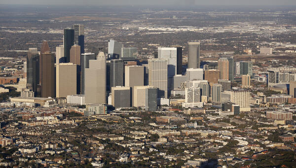
Downtown Houston, Texas, and the surrounding area
This aerial photo shows downtown Houston, Texas, and the surrounding area in January 2017 shortly before the city hosted the Super Bowl. Public domain photo by Glenn Fawcett of U.S. Customs and Border Protection.
This aerial photo shows downtown Houston, Texas, and the surrounding area in January 2017 shortly before the city hosted the Super Bowl. Public domain photo by Glenn Fawcett of U.S. Customs and Border Protection.

Landsat 8 image of Erte Ale, Ethiopia volcano, eruption, January 2017
The Operational Land Imager (OLI) onboard Landsat 8 captured this image an eruption from Ethiopia's Erte Ale volcano in late January of 2017.
The Operational Land Imager (OLI) onboard Landsat 8 captured this image an eruption from Ethiopia's Erte Ale volcano in late January of 2017.

Satellite Image of the Delaware Bay and Chesapeake Bay Region
This Indian Space Research Organization LISS-3 image of the Delaware Bay and Chesapeake Bay region, acquired on January 25, 2017, shows the landscape along the densely populated U.S. East coast. Ecosystems and sea-level rise are among the regional landscape changes that satellite imagery helps to monitor.
This Indian Space Research Organization LISS-3 image of the Delaware Bay and Chesapeake Bay region, acquired on January 25, 2017, shows the landscape along the densely populated U.S. East coast. Ecosystems and sea-level rise are among the regional landscape changes that satellite imagery helps to monitor.

Satellite image showing flooding in Argentina
Heavy rains in late December 2016 and early January 2017 are affecting soybean production in Argentina's bread-basket provinces while impacting soy prices worldwide.
Heavy rains in late December 2016 and early January 2017 are affecting soybean production in Argentina's bread-basket provinces while impacting soy prices worldwide.

Wildfires Scorch Pampas Region of Argentina
Since mid-December 2016, roughly two dozen wildfires in the Pampas region of Argentina have consumed almost 2.5 million acres while unleashing giant plumes of dense smoke above the rural landscapes.
Since mid-December 2016, roughly two dozen wildfires in the Pampas region of Argentina have consumed almost 2.5 million acres while unleashing giant plumes of dense smoke above the rural landscapes.

Storm amid the Calm
Even with the calming blue tones, there is an unsettling feeling in the jagged marks that lead to a circular feature. This feature is Gweni-Fada Crater, a meteorite impact crater in the Ennedi Plateau of northern Chad. In addition to the tension between calm and storm, there is a sense that this scene could pass as a view on another planet.
Even with the calming blue tones, there is an unsettling feeling in the jagged marks that lead to a circular feature. This feature is Gweni-Fada Crater, a meteorite impact crater in the Ennedi Plateau of northern Chad. In addition to the tension between calm and storm, there is a sense that this scene could pass as a view on another planet.