
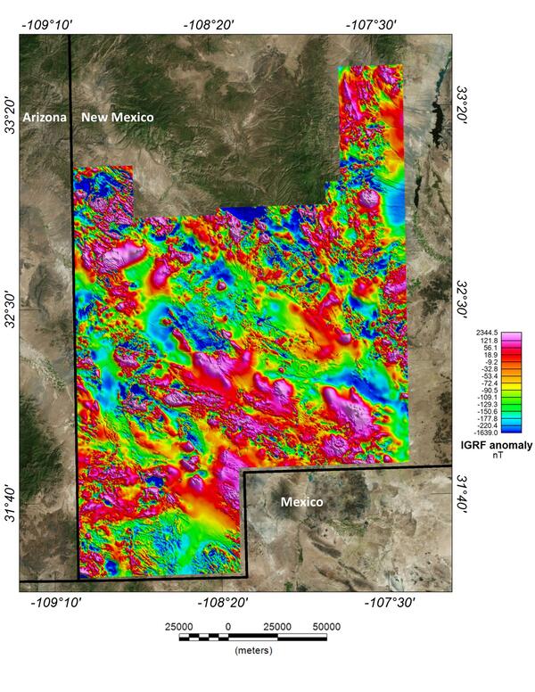
This image depicts the magnetic anomaly map of the region covered by the Southwest New Mexico aeromagnetic/aeroradiometric survey. These data allow us to model the subsurface structure and composition of the upper crust.
Images
Geology, Minerals, Energy, and Geophysics multi-media
Filter Total Items: 65
New Mexico porphyry copper belt aeromagnetic survey magnetic anomaly data
This image depicts the magnetic anomaly map of the region covered by the Southwest New Mexico aeromagnetic/aeroradiometric survey. These data allow us to model the subsurface structure and composition of the upper crust.

Saucer Shark Aeroshell and payload suspended by sling
USGS National Innovation Center UAS Research Center Saucer Shark Project, before science flight tests, Aeroshell and payload. Sling configuration and payload orientation verified before science flight deployment. Payload is on and ready to record!
USGS National Innovation Center UAS Research Center Saucer Shark Project, before science flight tests, Aeroshell and payload. Sling configuration and payload orientation verified before science flight deployment. Payload is on and ready to record!

BisonCore (MagEdition) displays live magnetic data (top) and lidar altitude (bottom)
USGS National Innovation Center UAS Research Center Saucer Shark Project, BisonCore displays the path of the sensor live, as it covers transects. Data received from the payload is then displayed within the BisonCore Ecosystem and is accessible for field viewing. The magnetic map is also used to validate payload directed algorithms.
USGS National Innovation Center UAS Research Center Saucer Shark Project, BisonCore displays the path of the sensor live, as it covers transects. Data received from the payload is then displayed within the BisonCore Ecosystem and is accessible for field viewing. The magnetic map is also used to validate payload directed algorithms.

Saucer Shark Deployed Below UAV
USGS National Innovation Center UAS Research Center (UASRC) Saucer Shark Project, during flight tests, fully assembled. Sub assemblies from top down: Drop Release, Sling and Sling Brace, Payload Aeroshell and Payload.
USGS National Innovation Center UAS Research Center (UASRC) Saucer Shark Project, during flight tests, fully assembled. Sub assemblies from top down: Drop Release, Sling and Sling Brace, Payload Aeroshell and Payload.

Saucer Shark Drop Release during testing campaign
USGS National Innovation Center UAS Research Center Saucer Shark Project, during flight tests, drop release attached to USGS UAV. Aircraft sits on landing pad in-between test flights.
USGS National Innovation Center UAS Research Center Saucer Shark Project, during flight tests, drop release attached to USGS UAV. Aircraft sits on landing pad in-between test flights.

Mountain Pass carbonatite thin section maps
Thin section of a Mountain Pass carbonatite sample showing mineralogy and texture with slider for back-scattered electron map (black and white) and layered elemental map (colored). Note the large, euhedral, tabular crystal of bastnäsite.
Thin section of a Mountain Pass carbonatite sample showing mineralogy and texture with slider for back-scattered electron map (black and white) and layered elemental map (colored). Note the large, euhedral, tabular crystal of bastnäsite.

Mountain Pass regional geologic map draped over topography
Geologic map overlaid on topography for the Mountain Pass region in California.
Geologic map overlaid on topography for the Mountain Pass region in California.

Drone at Sunset
A UAS flies a photogrammetry mission over recently burned landscapes in Tahoe National Forest.
A UAS flies a photogrammetry mission over recently burned landscapes in Tahoe National Forest.

Preflight Checks at Mosquito
Isaac Anderson (National Innovation Center) preforms a pre-flight check of a UAS before a photogrammetry mission in post-fire, landslide-prone terrain in Tahoe National Forest.
Isaac Anderson (National Innovation Center) preforms a pre-flight check of a UAS before a photogrammetry mission in post-fire, landslide-prone terrain in Tahoe National Forest.

Landing at Mosquito
Isaac Anderson and Liz Hyde (National Innovation Center) bring in a drone for a landing, after flying a photogrammetry mission over landslide-prone terrain recently burned in the Mosquito fire (2022).
Isaac Anderson and Liz Hyde (National Innovation Center) bring in a drone for a landing, after flying a photogrammetry mission over landslide-prone terrain recently burned in the Mosquito fire (2022).

Mosquito Ridge at Sunset
USGS researches and remote pilots coordinate their operations during a break in the action during a photogrammetry flight campaign in post-fire terrain in Tahoe National Forest.
USGS researches and remote pilots coordinate their operations during a break in the action during a photogrammetry flight campaign in post-fire terrain in Tahoe National Forest.

Saucer Shark project equipment identifying marker
USGS NIC UASRC Saucer Shark equipment marker showing the Saucer flying over trees, with a ‘I WANT TO BELIEVE’ phrase below it.
USGS NIC UASRC Saucer Shark equipment marker showing the Saucer flying over trees, with a ‘I WANT TO BELIEVE’ phrase below it.

Mountain Pass mine in California
Open pit rare earth element mine at Mountain Pass, California. Stepped sides of the pit and access for mining vehicles are shown.
Open pit rare earth element mine at Mountain Pass, California. Stepped sides of the pit and access for mining vehicles are shown.
Mountain Pass REE mine in California
Open pit rare earth element mine at Mountain Pass, California. Stepped sides of the pit and access for mining vehicles are shown.
Open pit rare earth element mine at Mountain Pass, California. Stepped sides of the pit and access for mining vehicles are shown.

geothermal monitoring.jpg
Photo of the drone performing a low-altitude gas survey to monitor gas emissions near Mammoth Lakes, CA. In the foreground (the white outcrops) is a fumarole. The dead trees in the background are due to tree-kill from heated ground temperatures
Photo of the drone performing a low-altitude gas survey to monitor gas emissions near Mammoth Lakes, CA. In the foreground (the white outcrops) is a fumarole. The dead trees in the background are due to tree-kill from heated ground temperatures

MAvery Profile Photo.jpg
Maggie Avery is facing forward on the left side of the image with a red USGS baseball cap and turquoise shirt with dark gray vest. There is a valley with a city next to water and mountains in the background.
Maggie Avery is facing forward on the left side of the image with a red USGS baseball cap and turquoise shirt with dark gray vest. There is a valley with a city next to water and mountains in the background.

NASA SSERVI Lunar Regolith Lab
NASA SSERVI Lunar Regolith Lab's anorthosite mineral test bed located at Moffett Field, California
NASA SSERVI Lunar Regolith Lab's anorthosite mineral test bed located at Moffett Field, California

Steamboat Rock pano.jpg
Steamboat Rock is a basalt "island" left over from the erosion during the glacial Missoula Floods.
Steamboat Rock is a basalt "island" left over from the erosion during the glacial Missoula Floods.

Hillshade of lidar acquired within the Pinto Mountain Fault Zone
The image shown displays a portion of the lidar data collected by the USGS for the SAFSOC Project. Our goal is to study and map surficial processes and landforms related to tectonism, specifically the San Andreas Fault system.
The image shown displays a portion of the lidar data collected by the USGS for the SAFSOC Project. Our goal is to study and map surficial processes and landforms related to tectonism, specifically the San Andreas Fault system.

Upstream view of the Columbia River flowing through the Hanford reach
The Columbia River flowing through the Hanford reach of the arid Columbia River basin, eastern Washington. This reach is one of the few undammed segments of the Columbia River within the United States. Photograph taken from the White Bluffs, composed of sediment deposited in late Miocene and Pliocene Lake Ringold which occupied the Pasco Basin.
The Columbia River flowing through the Hanford reach of the arid Columbia River basin, eastern Washington. This reach is one of the few undammed segments of the Columbia River within the United States. Photograph taken from the White Bluffs, composed of sediment deposited in late Miocene and Pliocene Lake Ringold which occupied the Pasco Basin.