
Hinkley Valley, in the central to western Mojave Desert of southeastern California, has a long historical record owing to its position as a crossroads for rail and road traffic and its position adjacent to the Mojave River.
Images
Geology, Minerals, Energy, and Geophysics multi-media
Filter Total Items: 65

Geologic Map and Borehole Stratigraphy of Hinkley Valley and Vicinity,
Hinkley Valley, in the central to western Mojave Desert of southeastern California, has a long historical record owing to its position as a crossroads for rail and road traffic and its position adjacent to the Mojave River.
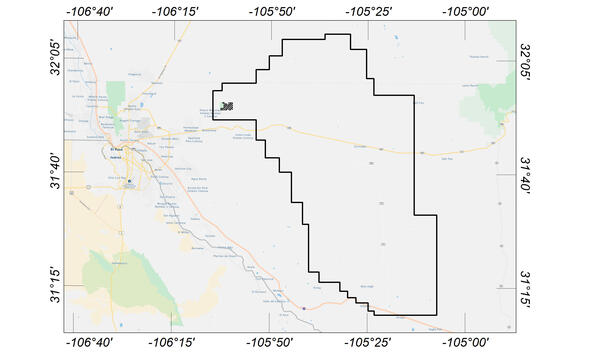
Flight area for Trans-Pecos aeromagnetic and radiometric survey
Map indicating flight area for Trans-Pecos aeromagnetic and radiometric survey. The survey area includes parts of El Paso and Hudspeth counties, Texas, and Otero County, New Mexico. Flights will begin in November 2020 and are expected to conclude in mid-January 2021.
Map indicating flight area for Trans-Pecos aeromagnetic and radiometric survey. The survey area includes parts of El Paso and Hudspeth counties, Texas, and Otero County, New Mexico. Flights will begin in November 2020 and are expected to conclude in mid-January 2021.

Confluence of the Deschutes and Columbia rivers
An enigmatic outcrop of 5 million year old basalt sits 300 meters above the Deschutes and Columbia rivers. USGS scientists are carefully studying this basalt flow to determine if it came all the way from central Oregon, 160 kilometers away.
An enigmatic outcrop of 5 million year old basalt sits 300 meters above the Deschutes and Columbia rivers. USGS scientists are carefully studying this basalt flow to determine if it came all the way from central Oregon, 160 kilometers away.

UAS over flux tower
Looking up at a drone hovering near an open-path methane analyzer mounted on a flux tower. Instruments mounted on both the towers and on the drones are measuring gases emitted from the soil.
Looking up at a drone hovering near an open-path methane analyzer mounted on a flux tower. Instruments mounted on both the towers and on the drones are measuring gases emitted from the soil.

Airborne Radiometric Maps of Mountain Pass, California
Geophysical investigations of Mountain Pass, California, were conducted as part of an effort to study regional crustal structures as an aid to understanding the geologic framework and mineral resources of the eastern Mojave Desert. The study area encompasses Mountain Pass, which is host to one of the world’s largest rare earth element (REE) carbonatite deposits.
Geophysical investigations of Mountain Pass, California, were conducted as part of an effort to study regional crustal structures as an aid to understanding the geologic framework and mineral resources of the eastern Mojave Desert. The study area encompasses Mountain Pass, which is host to one of the world’s largest rare earth element (REE) carbonatite deposits.

The Columbia River and Miller Island
A panoramic view of the Columbia River and Miller Island near the eastern end of the Columbia River Gorge National Scenic Area. The island and cliff walls on both sides of the Columbia River are composed of stacked lava flows of the Columbia River Basalt Group.
A panoramic view of the Columbia River and Miller Island near the eastern end of the Columbia River Gorge National Scenic Area. The island and cliff walls on both sides of the Columbia River are composed of stacked lava flows of the Columbia River Basalt Group.

Geologists examining a carbonatite dike
Geologists from the USGS and the New Mexico Bureau of Geology and Mineral Resources examining a carbonatite dike in the Lemitar Mountains, New Mexico
Geologists from the USGS and the New Mexico Bureau of Geology and Mineral Resources examining a carbonatite dike in the Lemitar Mountains, New Mexico

Scientist studying a carbonatite dike
Virginia McLemore, New Mexico Bureau of Geology and Mineral Resources, discussing a carbonatite dike in the Lemitar Mountains, New Mexico
Virginia McLemore, New Mexico Bureau of Geology and Mineral Resources, discussing a carbonatite dike in the Lemitar Mountains, New Mexico

Caddisfly larva (Limnephilus sp.)
Aquatic insects such as the caddisfly larva (Limnephilus sp.) are dominant macroinvertebrates in the spring systems in the Grand Canyon region.
Aquatic insects such as the caddisfly larva (Limnephilus sp.) are dominant macroinvertebrates in the spring systems in the Grand Canyon region.

Twilight in the Northern Bristol Mountains
Rain clouds at twilight over the Norhtern Bristol Mountains. THese types of winter storms provide water to the desert ecosystem, but are not usually intense enough to transport sediment or do other geomorphic work.
Rain clouds at twilight over the Norhtern Bristol Mountains. THese types of winter storms provide water to the desert ecosystem, but are not usually intense enough to transport sediment or do other geomorphic work.

Lineations on a strand of the Soda-Avawatz Fault Zone northern Soda Mt
Lineations on a vertical fault strand of the Soda-Avawatz Fault Zone, exposed in the northern Soda Mountains, Mojave Desert, southern California. The fault can be seen cutting both late Tertiary sand and gravel units, but is buried by an overlying mid-Pleistocene alluvial gravel deposit.
Lineations on a vertical fault strand of the Soda-Avawatz Fault Zone, exposed in the northern Soda Mountains, Mojave Desert, southern California. The fault can be seen cutting both late Tertiary sand and gravel units, but is buried by an overlying mid-Pleistocene alluvial gravel deposit.

Research Geologist Jonathan Perkins measuring post-fire infiltration
Research Geologist Jonathan Perkins adjusting tension in infiltrometer to evaluate post-fire recovery conditions in the Pepperwood Preserve, Santa Rosa, CA following the October 2017 Tubbs Fire to better understand how landscapes heal after wildfire.
Research Geologist Jonathan Perkins adjusting tension in infiltrometer to evaluate post-fire recovery conditions in the Pepperwood Preserve, Santa Rosa, CA following the October 2017 Tubbs Fire to better understand how landscapes heal after wildfire.

Natural oil seep along Tarwater Creek, San Mateo County, California
The natural oil seep in this photo is located in Pescadero Creek County Park, where the Canyon Trail crosses Tarwater Creek. The oil is black, has a taffy-like consistency, and smells like motor oil.
The natural oil seep in this photo is located in Pescadero Creek County Park, where the Canyon Trail crosses Tarwater Creek. The oil is black, has a taffy-like consistency, and smells like motor oil.

Oil well pumping unit, Half Moon Bay oil field, California
The Half Moon Bay oil field is one of the oldest oil fields in California and was first developed during the 1880s. Since then, the field has produced an estimated 60,000 barrels of oil from about 19 wells.
The Half Moon Bay oil field is one of the oldest oil fields in California and was first developed during the 1880s. Since then, the field has produced an estimated 60,000 barrels of oil from about 19 wells.

LS Preliminary Puerto Rico
Excerpt of satellite image showing landslide impacts to roads, agriculture, and a reservoir in the Lares Municipality. Points identify the approximate location of roads visibly impacted by landslides. Image filename contains approximate latitude and longitude of this impact location.
Excerpt of satellite image showing landslide impacts to roads, agriculture, and a reservoir in the Lares Municipality. Points identify the approximate location of roads visibly impacted by landslides. Image filename contains approximate latitude and longitude of this impact location.

Soda-Avawatz Fault, eastern Avawatz Mountains
This is a view to the southwest from the top of the piedmont on the eastern side of the Avawatz Mountains, ~25 km northwest of Baker, CA.
This is a view to the southwest from the top of the piedmont on the eastern side of the Avawatz Mountains, ~25 km northwest of Baker, CA.

Sampling soil carbon dioxide on Santa Rosa Island
USGS Scientist sampling soil gasses from a grassy hilltop soil on Santa Rosa Island, Channel Islands National Park, California. The composition of soil gasses is indicative of the number and variety of microorganisms in the soil and what type of material they are digesting.
USGS Scientist sampling soil gasses from a grassy hilltop soil on Santa Rosa Island, Channel Islands National Park, California. The composition of soil gasses is indicative of the number and variety of microorganisms in the soil and what type of material they are digesting.

Landslide impacting a house
Landslides triggered by high intensity rainfall impacted homes and roads in the San Francisco Bay area in 2017.
Landslides triggered by high intensity rainfall impacted homes and roads in the San Francisco Bay area in 2017.

Stibnite Mineral Specimen
Specimen of stibnite, an ore mineral of antimony. Antimony compounds help to prevent skin burns, increase battery life, and refine the glass used in cell-phone screens.
Specimen of stibnite, an ore mineral of antimony. Antimony compounds help to prevent skin burns, increase battery life, and refine the glass used in cell-phone screens.

GPS data collection along the Big Sur coast in 2007 (L), and 2015 (R)
Left: USGS research hydrologist Mark Reid (left) and USGS research geologist Kevin Schmidt collect GPS data along the Big Sur coast on September 19, 2007. Photo credit: Maiana Hanshaw, USGS (now with swisstopo).
Left: USGS research hydrologist Mark Reid (left) and USGS research geologist Kevin Schmidt collect GPS data along the Big Sur coast on September 19, 2007. Photo credit: Maiana Hanshaw, USGS (now with swisstopo).

Collecting glacial moraine boulder samples
This is an example of a boulder that is part of a glacial deposit in the southern Sawatch Mountains of Colorado. The moraine slopes down to the left side of the frame; this slope is modified from teh original depositional shape of the moraine deposit.
This is an example of a boulder that is part of a glacial deposit in the southern Sawatch Mountains of Colorado. The moraine slopes down to the left side of the frame; this slope is modified from teh original depositional shape of the moraine deposit.