
Two video cameras are installed atop a utility pole near the northernmost point of land in the United States at Nuvuk (Point Barrow), Alaska. The cameras point northwest toward the Arctic Ocean and the boundary between the Chukchi and Beaufort Seas. Every half hour during daylight hours, the cameras collect snapshots and video for 10 minutes.
Webcams
Webcams intro.
Filter Total Items: 60

Nuvuk video camera 2 bright image
Two video cameras are installed atop a utility pole near the northernmost point of land in the United States at Nuvuk (Point Barrow), Alaska. The cameras point northwest toward the Arctic Ocean and the boundary between the Chukchi and Beaufort Seas. Every half hour during daylight hours, the cameras collect snapshots and video for 10 minutes.

Nuvuk video camera 1 dark image
Two video cameras are installed atop a utility pole near the northernmost point of land in the United States at Nuvuk (Point Barrow), Alaska. The cameras point northwest toward the Arctic Ocean and the boundary between the Chukchi and Beaufort Seas. Every half hour during daylight hours, the cameras collect snapshots and video for 10 minutes.
Two video cameras are installed atop a utility pole near the northernmost point of land in the United States at Nuvuk (Point Barrow), Alaska. The cameras point northwest toward the Arctic Ocean and the boundary between the Chukchi and Beaufort Seas. Every half hour during daylight hours, the cameras collect snapshots and video for 10 minutes.

Nuvuk video camera 2 dark image
Two video cameras are installed atop a utility pole near the northernmost point of land in the United States at Nuvuk (Point Barrow), Alaska. The cameras point northwest toward the Arctic Ocean and the boundary between the Chukchi and Beaufort Seas. Every half hour during daylight hours, the cameras collect snapshots and video for 10 minutes.
Two video cameras are installed atop a utility pole near the northernmost point of land in the United States at Nuvuk (Point Barrow), Alaska. The cameras point northwest toward the Arctic Ocean and the boundary between the Chukchi and Beaufort Seas. Every half hour during daylight hours, the cameras collect snapshots and video for 10 minutes.

Nuvuk video camera 2 snapshop
Two video cameras are installed atop a utility pole near the northernmost point of land in the United States at Nuvuk (Point Barrow), Alaska. The cameras point northwest toward the Arctic Ocean and the boundary between the Chukchi and Beaufort Seas. Every half hour during daylight hours, the cameras collect snapshots and video for 10 minutes.
Two video cameras are installed atop a utility pole near the northernmost point of land in the United States at Nuvuk (Point Barrow), Alaska. The cameras point northwest toward the Arctic Ocean and the boundary between the Chukchi and Beaufort Seas. Every half hour during daylight hours, the cameras collect snapshots and video for 10 minutes.

Nuvuk video camera 1 time exposure
Two video cameras are installed atop a utility pole near the northernmost point of land in the United States at Nuvuk (Point Barrow), Alaska. The cameras point northwest toward the Arctic Ocean and the boundary between the Chukchi and Beaufort Seas. Every half hour during daylight hours, the cameras collect snapshots and video for 10 minutes.
Two video cameras are installed atop a utility pole near the northernmost point of land in the United States at Nuvuk (Point Barrow), Alaska. The cameras point northwest toward the Arctic Ocean and the boundary between the Chukchi and Beaufort Seas. Every half hour during daylight hours, the cameras collect snapshots and video for 10 minutes.

Nuvuk video camera 2 time exposure
Two video cameras are installed atop a utility pole near the northernmost point of land in the United States at Nuvuk (Point Barrow), Alaska. The cameras point northwest toward the Arctic Ocean and the boundary between the Chukchi and Beaufort Seas. Every half hour during daylight hours, the cameras collect snapshots and video for 10 minutes.
Two video cameras are installed atop a utility pole near the northernmost point of land in the United States at Nuvuk (Point Barrow), Alaska. The cameras point northwest toward the Arctic Ocean and the boundary between the Chukchi and Beaufort Seas. Every half hour during daylight hours, the cameras collect snapshots and video for 10 minutes.

Nuvuk video camera 1 variance image
Two video cameras are installed atop a utility pole near the northernmost point of land in the United States at Nuvuk (Point Barrow), Alaska. The cameras point northwest toward the Arctic Ocean and the boundary between the Chukchi and Beaufort Seas. Every half hour during daylight hours, the cameras collect snapshots and video for 10 minutes.
Two video cameras are installed atop a utility pole near the northernmost point of land in the United States at Nuvuk (Point Barrow), Alaska. The cameras point northwest toward the Arctic Ocean and the boundary between the Chukchi and Beaufort Seas. Every half hour during daylight hours, the cameras collect snapshots and video for 10 minutes.

Nuvuk video camera 2 variance image
Two video cameras are installed atop a utility pole near the northernmost point of land in the United States at Nuvuk (Point Barrow), Alaska. The cameras point northwest toward the Arctic Ocean and the boundary between the Chukchi and Beaufort Seas. Every half hour during daylight hours, the cameras collect snapshots and video for 10 minutes.
Two video cameras are installed atop a utility pole near the northernmost point of land in the United States at Nuvuk (Point Barrow), Alaska. The cameras point northwest toward the Arctic Ocean and the boundary between the Chukchi and Beaufort Seas. Every half hour during daylight hours, the cameras collect snapshots and video for 10 minutes.

Nuvuk video camera 1 bright image
Two video cameras are installed atop a utility pole near the northernmost point of land in the United States at Nuvuk (Point Barrow), Alaska. The cameras point northwest toward the Arctic Ocean and the boundary between the Chukchi and Beaufort Seas. Every half hour during daylight hours, the cameras collect snapshots and video for 10 minutes.
Two video cameras are installed atop a utility pole near the northernmost point of land in the United States at Nuvuk (Point Barrow), Alaska. The cameras point northwest toward the Arctic Ocean and the boundary between the Chukchi and Beaufort Seas. Every half hour during daylight hours, the cameras collect snapshots and video for 10 minutes.

Nuvuk video camera 1 snapshot
Two video cameras are installed atop a utility pole near the northernmost point of land in the United States at Nuvuk (Point Barrow), Alaska. The cameras point northwest toward the Arctic Ocean and the boundary between the Chukchi and Beaufort Seas. Every half hour during daylight hours, the cameras collect snapshots and video for 10 minutes.
Two video cameras are installed atop a utility pole near the northernmost point of land in the United States at Nuvuk (Point Barrow), Alaska. The cameras point northwest toward the Arctic Ocean and the boundary between the Chukchi and Beaufort Seas. Every half hour during daylight hours, the cameras collect snapshots and video for 10 minutes.

Sunset Beach Camera 1 Bright Image
Video camera snapshot at Sunset State Beach in Watsonville, California, looking northwest. Learn more about the cameras and their imagery, and how we're using them to study coastal change.
Video camera snapshot at Sunset State Beach in Watsonville, California, looking northwest. Learn more about the cameras and their imagery, and how we're using them to study coastal change.
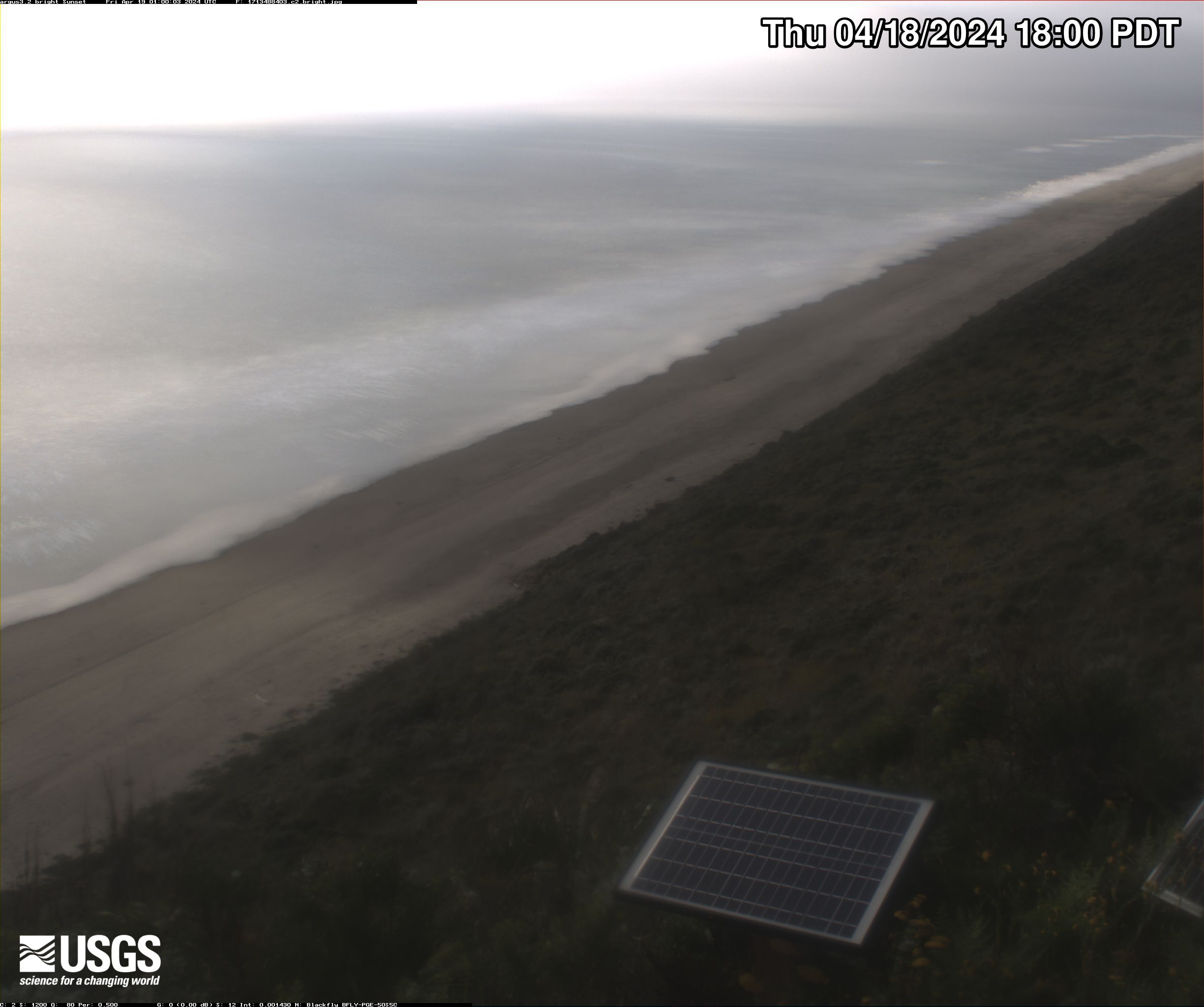
Sunset Beach Camera 2 Bright Image
Video camera bright image at Sunset State Beach in Watsonville, California, looking north. Learn more about the cameras and their imagery, and how we're using them to study coastal change.
Video camera bright image at Sunset State Beach in Watsonville, California, looking north. Learn more about the cameras and their imagery, and how we're using them to study coastal change.

Sunset Beach Camera 1 Dark Image
Video camera dark image at Sunset State Beach in Watsonville, California, looking northwest. Learn more about the cameras and their imagery, and how we're using them to study coastal change.
Video camera dark image at Sunset State Beach in Watsonville, California, looking northwest. Learn more about the cameras and their imagery, and how we're using them to study coastal change.

Sunset Beach Camera 2 Dark Image
Video camera bright image at Sunset State Beach in Watsonville, California, looking north. Learn more about the cameras and their imagery, and how we're using them to study coastal change.
Video camera bright image at Sunset State Beach in Watsonville, California, looking north. Learn more about the cameras and their imagery, and how we're using them to study coastal change.

Sunset Beach Camera 1 Snapshot
Video camera snapshot at Sunset State Beach in Watsonville, California, looking northwest. Learn more about the cameras and how we're using them to study coastal change.
Video camera snapshot at Sunset State Beach in Watsonville, California, looking northwest. Learn more about the cameras and how we're using them to study coastal change.

Sunset Beach Camera 2 Snapshot
Video camera snapshot at Sunset State Beach in Watsonville, California, looking north. Learn more about the cameras and how we're using them to study coastal change.
Video camera snapshot at Sunset State Beach in Watsonville, California, looking north. Learn more about the cameras and how we're using them to study coastal change.

Sunset Beach Camera 1 Timex
Video camera timex (time-exposure) image at Sunset State Beach in Watsonville, California, looking northwest. Learn more about the cameras and how we're using them to study coastal change.
Video camera timex (time-exposure) image at Sunset State Beach in Watsonville, California, looking northwest. Learn more about the cameras and how we're using them to study coastal change.

Sunset Beach Camera 2 Timex
Video camera timex (time-exposure) image at Sunset State Beach in Watsonville, California, looking north. Learn more about the cameras and how we're using them to study coastal change.
Video camera timex (time-exposure) image at Sunset State Beach in Watsonville, California, looking north. Learn more about the cameras and how we're using them to study coastal change.

Sunset Beach Camera 1 Variance
Video camera variance image at Sunset State Beach in Watsonville, California, looking northwest. Learn more about the cameras and their imagery, and how we're using them to study coastal change.
View a larger version
Video camera variance image at Sunset State Beach in Watsonville, California, looking northwest. Learn more about the cameras and their imagery, and how we're using them to study coastal change.
View a larger version

Sunset Beach Camera 2 Variance
Video camera variance image at Sunset State Beach in Watsonville, California, looking north. Learn more about the cameras and their imagery, and how we're using them to study coastal change.
Video camera variance image at Sunset State Beach in Watsonville, California, looking north. Learn more about the cameras and their imagery, and how we're using them to study coastal change.
Tres Palmas Video Camera Beach View Dark Image
Video camera dark image at Tres Palmas in Rincón, on the west coast of Puerto Rico. [Larger version]
Learn more about the cameras and how we're using them to study wave dynamics.
Video camera dark image at Tres Palmas in Rincón, on the west coast of Puerto Rico. [Larger version]
Learn more about the cameras and how we're using them to study wave dynamics.