
Greater Sage-Grouse Population Monitoring Framework Data Inputs Information Sheet
To support management decisions, western state wildlife agencies identified the need for a range-wide database that tracks annual counts of greater sage-grouse (Centrocercus urophasianus; sage-grouse) at leks (breeding sites), recorded since the early 1950s. Researchers at Colorado State University (CSU) and U.S. Geological Survey (USGS) worked with state wildlife agencies to 1) construct this range-wide lek count database, and 2) develop biologically relevant and spatially nested sage-grouse Clusters that could inform monitoring and management actions intended to benefit sage-grouse populations and habitats.
Research Objective
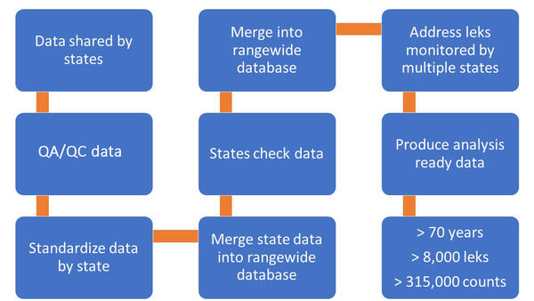
The range-wide sage-grouse population database presents one of the most extensive wildlife monitoring efforts worldwide and provides a significant resource to inform wildlife and habitat management for a species previously considered for listing under the Endangered Species Act. Eleven state agencies provided the lek count data that serves as the foundation of the database (Figure 1). The database is housed at CSU based on established agreements with the state wildlife agencies. USGS used this database to develop the population monitoring framework. The compilation of lek data across the range allows for new and comprehensive inference on sage-grouse population trends that inform effective management. Because the database is annually updated with the most recently available information, it supports management decisions in real time.
The Clusters provide new, biologically relevant boundaries to monitor sage-grouse trends across several spatial scales and administrative boundaries. Wildlife management boundaries interrupted by state borders and other administrate boundaries disrupting biological context and methods used to evaluate populations. Consequently, challenges arise with effective population management due to contiguous populations with variable management across administrative borders. The hierarchical Clusters capture factors that influence both regional trends as well as population structure and connectivity. These spatial units support future investigations of factors affecting populations while considering multiple biologically based scales and alleviate the mismatch between jurisdictional units and the biological scale of sage-grouse population response. This allows practitioners to manage sage-grouse at biologically relevant scales that promote effective outcomes.

Researchers developed the Clusters (that is, nested population units) by grouping leks across the species’ range at different spatial scales. These Clusters were then used to estimate population trends across 13 spatial scales. Two of those scales were selected to represent a fine (Neighborhood Cluster) and broad spatial scale (Climate Cluster) with input from state wildlife agencies. We used movement data from radio and global positioning system (GPS) marked sage-grouse to inform the NC scale, and relationships between precipitation and rate of change in population abundance to inform the Climate Cluster scale.
Trends estimated at the Climate Cluster-scale capture regional environmental conditions (Figure 2). Lek and Neighborhood Cluster-scales capture environmental conditions as well as local disturbances ranging in size from point sources like infrastructure development to large wildfires. Neighborhood Clusters have an additional advantage of encompassing a significant portion of movement, therefore minimizing movement in and out of unit boundaries, which reduces the impact of migration on trends in population size.
Together, the range-wide sage-grouse population database and the population Clusters serve as the basis for developing a hierarchical Population Monitoring Framework for sage-grouse management. This framework allows managers to assess regional and local sage-grouse population trends over time and to target populations that may warrant additional monitoring or management and to adjust management actions based on near real-time population changes. Therefore, these products can greatly assist state and federal agencies in making informed, targeted, and cost-effective decisions within an adaptive management framework.
Future co-production
We continue working with all collaborators to improve the science needed for sage-grouse management. Each year, a new standardized lek count database is developed to include newly digitized historical data and improve data quality using critical quality control methods. During this process, software is updated and released to the public. The trends and TAWS models are run with the most recent lek data provided by state partners. The results are released in a USGS Data Series report and included in the trends and TAWS decision support software. We continue to inform partners of updates and improvements to the model and facilitate the incorporation of new features and outputs within the application.
Data restrictions
State wildlife agencies collect and manage lek databases. Because sage-grouse are a species of conservation concern and sensitive to activities during breeding, these data are available only after acquiring data-sharing agreements with individual states.
Funders
U.S. Geological Survey (Ecosystem Mission Area, Land Management Research Program and Species Management Research Program, Wyoming Landscape Conservation Initiative) and U.S. Bureau of Land Management.
Partners
State Wildlife Agencies (California Department of Fish and Wildlife; Colorado Parks and Wildlife; Idaho Department of Fish and Game; Montana Fish, Wildlife & Parks; Nevada Department of Wildlife; North Dakota Game and Fish Department; Oregon Department of Fish and Wildlife; South Dakota Department of Game, Fish and Parks; Utah Division of Wildlife Resources; Wyoming Game and Fish Department; Washington Department of Fish and Wildlife), Colorado State University, BLM, US Fish and Wildlife Service, US Forest Service, researchers who provided field data to evaluate results.

Greater Sage-Grouse Population Monitoring Framework

Data Harmonization for Greater Sage-Grouse Populations

Hierarchical Units of Greater Sage-Grouse Populations Informing Wildlife Management
To support management decisions, western state wildlife agencies identified the need for a range-wide database that tracks annual counts of greater sage-grouse (Centrocercus urophasianus; sage-grouse) at leks (breeding sites), recorded since the early 1950s. Researchers at Colorado State University (CSU) and U.S. Geological Survey (USGS) worked with state wildlife agencies to 1) construct this range-wide lek count database, and 2) develop biologically relevant and spatially nested sage-grouse Clusters that could inform monitoring and management actions intended to benefit sage-grouse populations and habitats.
Research Objective
The range-wide sage-grouse population database presents one of the most extensive wildlife monitoring efforts worldwide and provides a significant resource to inform wildlife and habitat management for a species previously considered for listing under the Endangered Species Act. Eleven state agencies provided the lek count data that serves as the foundation of the database (Figure 1). The database is housed at CSU based on established agreements with the state wildlife agencies. USGS used this database to develop the population monitoring framework. The compilation of lek data across the range allows for new and comprehensive inference on sage-grouse population trends that inform effective management. Because the database is annually updated with the most recently available information, it supports management decisions in real time.
The Clusters provide new, biologically relevant boundaries to monitor sage-grouse trends across several spatial scales and administrative boundaries. Wildlife management boundaries interrupted by state borders and other administrate boundaries disrupting biological context and methods used to evaluate populations. Consequently, challenges arise with effective population management due to contiguous populations with variable management across administrative borders. The hierarchical Clusters capture factors that influence both regional trends as well as population structure and connectivity. These spatial units support future investigations of factors affecting populations while considering multiple biologically based scales and alleviate the mismatch between jurisdictional units and the biological scale of sage-grouse population response. This allows practitioners to manage sage-grouse at biologically relevant scales that promote effective outcomes.
Researchers developed the Clusters (that is, nested population units) by grouping leks across the species’ range at different spatial scales. These Clusters were then used to estimate population trends across 13 spatial scales. Two of those scales were selected to represent a fine (Neighborhood Cluster) and broad spatial scale (Climate Cluster) with input from state wildlife agencies. We used movement data from radio and global positioning system (GPS) marked sage-grouse to inform the NC scale, and relationships between precipitation and rate of change in population abundance to inform the Climate Cluster scale.
Trends estimated at the Climate Cluster-scale capture regional environmental conditions (Figure 2). Lek and Neighborhood Cluster-scales capture environmental conditions as well as local disturbances ranging in size from point sources like infrastructure development to large wildfires. Neighborhood Clusters have an additional advantage of encompassing a significant portion of movement, therefore minimizing movement in and out of unit boundaries, which reduces the impact of migration on trends in population size.
Together, the range-wide sage-grouse population database and the population Clusters serve as the basis for developing a hierarchical Population Monitoring Framework for sage-grouse management. This framework allows managers to assess regional and local sage-grouse population trends over time and to target populations that may warrant additional monitoring or management and to adjust management actions based on near real-time population changes. Therefore, these products can greatly assist state and federal agencies in making informed, targeted, and cost-effective decisions within an adaptive management framework.
Future co-production
We continue working with all collaborators to improve the science needed for sage-grouse management. Each year, a new standardized lek count database is developed to include newly digitized historical data and improve data quality using critical quality control methods. During this process, software is updated and released to the public. The trends and TAWS models are run with the most recent lek data provided by state partners. The results are released in a USGS Data Series report and included in the trends and TAWS decision support software. We continue to inform partners of updates and improvements to the model and facilitate the incorporation of new features and outputs within the application.
Data restrictions
State wildlife agencies collect and manage lek databases. Because sage-grouse are a species of conservation concern and sensitive to activities during breeding, these data are available only after acquiring data-sharing agreements with individual states.
Funders
U.S. Geological Survey (Ecosystem Mission Area, Land Management Research Program and Species Management Research Program, Wyoming Landscape Conservation Initiative) and U.S. Bureau of Land Management.
Partners
State Wildlife Agencies (California Department of Fish and Wildlife; Colorado Parks and Wildlife; Idaho Department of Fish and Game; Montana Fish, Wildlife & Parks; Nevada Department of Wildlife; North Dakota Game and Fish Department; Oregon Department of Fish and Wildlife; South Dakota Department of Game, Fish and Parks; Utah Division of Wildlife Resources; Wyoming Game and Fish Department; Washington Department of Fish and Wildlife), Colorado State University, BLM, US Fish and Wildlife Service, US Forest Service, researchers who provided field data to evaluate results.