
Cover image for Elevation gain | Wetland loss animation. stylized water with a berm and wind cloud
Images
A picture is worth a thousand words. Take a look at some images capturing science activities at the USGS Wetland and Aquatic Research Center.
Filter Total Items: 173

Cover image for Elevation Gain | Wetland Loss
Cover image for Elevation gain | Wetland loss animation. stylized water with a berm and wind cloud

handful of mussels
This is a photo of a USGS employee holding a handful of Fatmucket mussels at Columbia Environmental Research Center. These mussels will be used for reintroduction.
This is a photo of a USGS employee holding a handful of Fatmucket mussels at Columbia Environmental Research Center. These mussels will be used for reintroduction.

USGS scientists mapping vegetation and land use in Los Planes watershed, Baja California Sur, Mexico
linkUSGS scientists mapping vegetation and land use in Los Planes watershed, Baja California Sur, Mexico, as part of a joint project to understand the impacts of installing natural infrastructure in dryland streams (NIDS), structures made from rock, sandbags and wood, meant

USGS scientists coordinate the rescue of over 60 sea turtles in cold weather snap
U.S. Geological Survey biologist Samantha Snow rescues a cold-stunned green sea turtle from the shores of St. Joseph Bay, Florida Jan. 23, 2024 during a recent cold weather event. About 60 sea turtles were transported from St. Joseph Bay to Gulf World Marine Institute for rehabilitation and medical treatment January 17-24, 2024.
U.S. Geological Survey biologist Samantha Snow rescues a cold-stunned green sea turtle from the shores of St. Joseph Bay, Florida Jan. 23, 2024 during a recent cold weather event. About 60 sea turtles were transported from St. Joseph Bay to Gulf World Marine Institute for rehabilitation and medical treatment January 17-24, 2024.

USGS scientists coordinate the rescue of over 60 sea turtles in cold weather snap
A cold-stunned green sea turtle near St. Joseph Bay, Florida moments before rescue by U.S. Geological Survey staff members January 23, 2024. The animals were pulled from fatal water temperatures off the coast of Florida and from beaches in a collaborative rescue event by the USGS, Florida Fish and Wildlife Conservation Commission, and the U.S.
A cold-stunned green sea turtle near St. Joseph Bay, Florida moments before rescue by U.S. Geological Survey staff members January 23, 2024. The animals were pulled from fatal water temperatures off the coast of Florida and from beaches in a collaborative rescue event by the USGS, Florida Fish and Wildlife Conservation Commission, and the U.S.

USGS scientists coordinate the rescue of over 60 sea turtles in cold weather snap
U.S. Geological Survey Biologist Dan Catizone prepares a cold-stunned green sea turtle for transport to Gulf World Marine Institute near St. Joseph Bay, Florida January 23, 2024.
U.S. Geological Survey Biologist Dan Catizone prepares a cold-stunned green sea turtle for transport to Gulf World Marine Institute near St. Joseph Bay, Florida January 23, 2024.

USGS scientists coordinate the rescue of over 60 sea turtles in cold weather snap
Margaret Lamont, a U.S. Geological Survey research biologist who has studied sea turtles for nearly 30 years, prepares a cold-stunned sea turtle for transport during a mass rescue event near St. Joseph Bay, Florida January 23, 2024. Water temperatures below 50 degrees Fahrenheit can be fatal to cold-blooded sea turtles, and about 60 were transported from St.
Margaret Lamont, a U.S. Geological Survey research biologist who has studied sea turtles for nearly 30 years, prepares a cold-stunned sea turtle for transport during a mass rescue event near St. Joseph Bay, Florida January 23, 2024. Water temperatures below 50 degrees Fahrenheit can be fatal to cold-blooded sea turtles, and about 60 were transported from St.
USGS scientists coordinate the rescue of over 60 sea turtles in cold weather snap
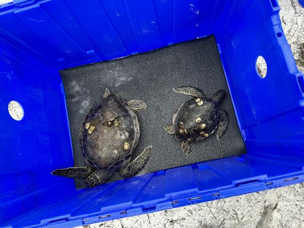
Cold-stunned green sea turtles rescued from fatal water temperatures in St. Joseph Bay, Florida by U.S. Geological Survey staff members are held temporarily in a crate before being transferred to Gulf World Marine Institute for rehabilitation and medical treatment January 23, 2024.
Cold-stunned green sea turtles rescued from fatal water temperatures in St. Joseph Bay, Florida by U.S. Geological Survey staff members are held temporarily in a crate before being transferred to Gulf World Marine Institute for rehabilitation and medical treatment January 23, 2024.

New method to detect white-nose syndrome fungus in bats developed
A new test for white-nose syndrome-causing fungus in bats has been developed using a CRISPR biosensor. If white-nose syndrome-causing fungus is present, the reaction tube will glow under UV light.
A new test for white-nose syndrome-causing fungus in bats has been developed using a CRISPR biosensor. If white-nose syndrome-causing fungus is present, the reaction tube will glow under UV light.

Teenage citizen-scientist helps USGS confirm unique population of threatened turtle
A young federally Threatened Ringed Map Turtle basks on a log near Covington, Louisiana. (Courtesy photo).
A young federally Threatened Ringed Map Turtle basks on a log near Covington, Louisiana. (Courtesy photo).

Teenage citizen-scientist helps USGS confirm unique population of threatened turtle
An adult female River Cooter, left, and an adult female federally-Threatened Ringed Map Turtle, right, bask in the sun near Covington, Louisiana. (Courtesy photo).
An adult female River Cooter, left, and an adult female federally-Threatened Ringed Map Turtle, right, bask in the sun near Covington, Louisiana. (Courtesy photo).

tilapia.jpg
David Boyd (LSU) with a tilapia, Oreochromis sp. (Credit: Madison Sinopoli, LSU)
David Boyd (LSU) with a tilapia, Oreochromis sp. (Credit: Madison Sinopoli, LSU)

Teenage citizen-scientist helps USGS confirm unique population of threatened turtle
Aidan Ford, a citizen-scientist, holds up two juvenile Ringed Map Turtles during fieldwork with the U.S. Geological Survey, on May 5, 2023 on the Bouge Falaya river, in Louisiana. (Courtesy photo).
Aidan Ford, a citizen-scientist, holds up two juvenile Ringed Map Turtles during fieldwork with the U.S. Geological Survey, on May 5, 2023 on the Bouge Falaya river, in Louisiana. (Courtesy photo).

USGS at Coastal Sediments 2023
The USGS was proud to be an exhibitor and sponsor at the Coastal Sediments Conference in New Orleans, Louisiana, in April 2023.
The USGS was proud to be an exhibitor and sponsor at the Coastal Sediments Conference in New Orleans, Louisiana, in April 2023.

USGS Invasive Species Exhibit at the 2023 St. Petersburg Science Festival
Emily Wei (SPCMSC), Kaitlin Kovacs (WARC), and Kayla Morningstar (WARC) prepare for a fun day of public outreach about USGS invasive species research at the St. Petersburg Science Festival. For more than 10 years, the St.
Emily Wei (SPCMSC), Kaitlin Kovacs (WARC), and Kayla Morningstar (WARC) prepare for a fun day of public outreach about USGS invasive species research at the St. Petersburg Science Festival. For more than 10 years, the St.

Kaitlin Kovacs Discusses Gulf Sturgeon at the 2023 St. Petersburg Science Festival
Kaitlin Kovacs (WARC) holds up a bony scute from a Gulf Sturgeon at the 2023 St. Petersburg Science Festival. For more than 10 years, the St. Petersburg Science Festival has celebrated STEAM (science, technology, engineering, art, and mathematics) activities with elementary school children and the public over a two-day event.
Kaitlin Kovacs (WARC) holds up a bony scute from a Gulf Sturgeon at the 2023 St. Petersburg Science Festival. For more than 10 years, the St. Petersburg Science Festival has celebrated STEAM (science, technology, engineering, art, and mathematics) activities with elementary school children and the public over a two-day event.

Dorothy Sifuentes Discusses Animal Tagging at the 2023 St. Petersburg Coastal and Marine Science Center
linkDorothy Sifuentes (Caribbean-Florida Water Science Center) discusses how tags are used to track movement and behavior of several aquatic imperiled species, like sea turtles. For more than 10 years, the St.

Caitlin Beaver Explains Environmental DNA at the 2023 St. Petersburg Science Festival
Caitlin Beaver (WARC) explains how environmental DNA (eDNA) is used to study invasive and imperiled species while at the 2023 St. Petersburg Science Festival. For more than 10 years, the St.
Caitlin Beaver (WARC) explains how environmental DNA (eDNA) is used to study invasive and imperiled species while at the 2023 St. Petersburg Science Festival. For more than 10 years, the St.

Overview of the coastal vegetation type products.png
Fig 2. Overview of the coastal vegetation type products by mapping vegetation using National Agriculture Imagery Program within Google Earth Engine and fusing these data to national land use/land cover products. The example land use/land cover product shown here is the 10-m beta version of NOAA’s Coastal Change Assessment Program maps.
Fig 2. Overview of the coastal vegetation type products by mapping vegetation using National Agriculture Imagery Program within Google Earth Engine and fusing these data to national land use/land cover products. The example land use/land cover product shown here is the 10-m beta version of NOAA’s Coastal Change Assessment Program maps.

Inter-dune coastal scrub and grass barrier island habitat
Inter-dune habitat with a mix of coastal scrub, bare ground, and grass vegetation, on Santa Rosa Island, Gulf Islands National Seashore, FL. The foredune (in background) separates the inter-dune habitat from beach habitat (not visible) behind the foredune.
Inter-dune habitat with a mix of coastal scrub, bare ground, and grass vegetation, on Santa Rosa Island, Gulf Islands National Seashore, FL. The foredune (in background) separates the inter-dune habitat from beach habitat (not visible) behind the foredune.