U.S. flag

An official website of the United States government

Images

A picture is worth a thousand words. Take a look at some images capturing science activities at the USGS Wetland and Aquatic Research Center. 

Filter Total Items: 162
Researchers aboard NOAA's R/V Bell M. Shimada prepare to deploy an autonomous underwater vehicle (AUV)

As part of the Expanding Pacific Research and Exploration of Submerged Systems (EXPRESS) 2022 expedition, researchers aboard NOAA's R/V Bell M. Shimada prepare to deploy an autonomous underwater vehicle (AUV).

As part of the Expanding Pacific Research and Exploration of Submerged Systems (EXPRESS) 2022 expedition, researchers aboard NOAA's R/V Bell M. Shimada prepare to deploy an autonomous underwater vehicle (AUV).

Nesting Brown Pelicans

Figure 2. Nesting Brown Pelicans within established mangrove habitat on the northern portion of Breton Island, summer 2022.

Figure 2. Nesting Brown Pelicans within established mangrove habitat on the northern portion of Breton Island, summer 2022.

Graphic showing structure of the ocean floor from beach to deep sea with descriptions
USGS Ocean Research
USGS Ocean Research
USGS Ocean Research

Our coasts, the most familiar part of the ocean are the gateway to the larger deeper ocean world. USGS studies processes and hazards in the coastal zone and how they affect people, wildlife, and ecosystems.

Our coasts, the most familiar part of the ocean are the gateway to the larger deeper ocean world. USGS studies processes and hazards in the coastal zone and how they affect people, wildlife, and ecosystems.

Walking catfish
Walking catfish
Walking catfish
Walking catfish

Cayla Morningstar (USGS) and Howard Jelks (USGS) show off a walking catfish, Clarias batrachus, during the March 2022 Fish Slam. Photo credit USGS

Cayla Morningstar (USGS) and Howard Jelks (USGS) show off a walking catfish, Clarias batrachus, during the March 2022 Fish Slam. Photo credit USGS

A Ringed Map Turtle basks on a log suspended above water.
Teenage citizen-scientist helps USGS confirm unique population of threatened turtle

This photo, taken by teenager Aidan Ford in 2021 of a Ringed Map Turtle near Covington, Louisiana, led to the conformation of a second, previously-unknown population of the species. (Photo courtesy of Aidan Ford). 

This photo, taken by teenager Aidan Ford in 2021 of a Ringed Map Turtle near Covington, Louisiana, led to the conformation of a second, previously-unknown population of the species. (Photo courtesy of Aidan Ford). 

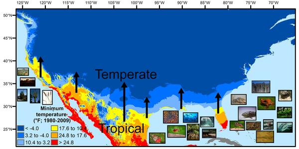
Map of U.S. mainland showing temperate, transitional and tropical temperature patterns
U.S. regions in the tropical-to-temperate transition

A map showing North America's tropical-to-temperate transition zone. Red, orange, and yellow depict the more tropical zones, and blues depict the more temperate zones, based on to the coldest recorded temperature for each area between 1980 and 2009.

A map showing North America's tropical-to-temperate transition zone. Red, orange, and yellow depict the more tropical zones, and blues depict the more temperate zones, based on to the coldest recorded temperature for each area between 1980 and 2009.

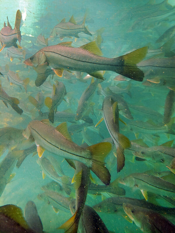
A school of snook, large subtropical game fish, in a Florida spring
Subtropical snook gather at a warm Florida springhead in winter

 Winter temperature extremes control the distributions of subtropical fishes. Common snook (Centropomus undecimalis), aggregate at a spring in northern Florida during winter. Snook are warm saltwater game fish, common in Florida, that have been moving further northward as extreme cold spells become less frequent and less intense.

 Winter temperature extremes control the distributions of subtropical fishes. Common snook (Centropomus undecimalis), aggregate at a spring in northern Florida during winter. Snook are warm saltwater game fish, common in Florida, that have been moving further northward as extreme cold spells become less frequent and less intense.

Two scientists in a lab hold a clear tube filled with mud.
Scientists process sediment cores from the deep sea

To help study the biodiversity present in the deep sea, scientists collect sediment cores. These cores are about a foot long and provide a vertical profile of deep-sea sediment, or mud.

To help study the biodiversity present in the deep sea, scientists collect sediment cores. These cores are about a foot long and provide a vertical profile of deep-sea sediment, or mud.

Reported lionfish sightings from 1985 - January 8, 2020

Reported lionfish sightings from 1985 - January 8, 2020

Data Source: U.S. Geological Survey, Nonindigenous Aquatic Species Database

Photograph of 2 UNC mini landers surrounded by Sablefish
UNC mini landers surrounded by Sablefish

 Two UNC mini landers, surrounded by Sablefish (Anoplopoma fimbria) and pink sea urchins, incubate seawater in situ to enable calculations of methane oxidation rates.

 Two UNC mini landers, surrounded by Sablefish (Anoplopoma fimbria) and pink sea urchins, incubate seawater in situ to enable calculations of methane oxidation rates.

Photograph of SuBastian’s manipulator jaw stabilizes GEOMAR’s glowing bubble box
SuBastian’s manipulator jaw stabilizes GEOMAR’s glowing bubble box

ROV SuBastian’s manipulator jaw stabilizes GEOMAR’s glowing bubble box that is capturing high-resolution images of methane bubbles rising from the seafloor.

Photograph of Red plumes burst out from the tops of these chemosynthetic tubeworms
Red plumes burst out from the tops of these chemosynthetic tubeworms

Red plumes burst out from the tops of these chemosynthetic tubeworms, capturing hydrogen sulfide and oxygen from the surrounding water to feed their bacterial endosymbionts. The tubeworm tubes provide a habitat for several benthic animals, including the pale pink branching octocorals seen here

Red plumes burst out from the tops of these chemosynthetic tubeworms, capturing hydrogen sulfide and oxygen from the surrounding water to feed their bacterial endosymbionts. The tubeworm tubes provide a habitat for several benthic animals, including the pale pink branching octocorals seen here

A Kemp's ridley sea turtle sits on the deck of a boat at night with a radio tag on her back.
Finley, a female Kemp's ridley sea turtle

A female Kemp's ridley sea turtle, named Finley, shows off the popoff ADL (orange) and satellite tag (blue).

A female Kemp's ridley sea turtle, named Finley, shows off the popoff ADL (orange) and satellite tag (blue).

Mangrove forests with water in the foreground and forest with dense aboveground roots
Mangrove forest in Pohnpei, Micronesia

Mangrove forest in Pohnpei, Micronesia.

The USGS and partners are studying how mangrove forests in the Federated States of Micronesia may respond to sea-level rise over the coming century. Their projections will help Micronesian communities plan for the future.

Mangrove forest in Pohnpei, Micronesia.

The USGS and partners are studying how mangrove forests in the Federated States of Micronesia may respond to sea-level rise over the coming century. Their projections will help Micronesian communities plan for the future.

Image shows two sea urchins with the ocean in the background
Red Sea Urchins
Red Sea Urchins
Red Sea Urchins

Two red sea urchins (Mesocentrotus franciscanus) sit on the deck of the R/V Falkor. These sea urchins were collected during the #HuntingBubbles research cruise led by the USGS and Schmidt Ocean Institute, which focused on exploring and understanding methane seeps and the communities that depend on them along the Cascadia Margin.

Two red sea urchins (Mesocentrotus franciscanus) sit on the deck of the R/V Falkor. These sea urchins were collected during the #HuntingBubbles research cruise led by the USGS and Schmidt Ocean Institute, which focused on exploring and understanding methane seeps and the communities that depend on them along the Cascadia Margin.

A turtle mosaic made from broken tiles
A sea turtle mosaic made from the field station's broken floor tiles

After Hurricane Michael obliterated Fish Inn, the sea turtle research team's field station, team members salvaged some of the building's floor tiles and made this sea turtle mosaic, which they plan to eventually install in a new field station.

After Hurricane Michael obliterated Fish Inn, the sea turtle research team's field station, team members salvaged some of the building's floor tiles and made this sea turtle mosaic, which they plan to eventually install in a new field station.

A spotted lizard shaped animal with red, frilly gills at the base of its head is in shallow water
Gulf Coast Waterdog - Necturus beyeri

Source: USGS National Wetlands Research Center. Photographer: Brad M. Glorioso. St. Tammany Parish, Louisiana

Necturus beyeri - Gulf Coast Waterdog

Source: USGS National Wetlands Research Center. Photographer: Brad M. Glorioso. St. Tammany Parish, Louisiana

Necturus beyeri - Gulf Coast Waterdog

Satellite photos of Cape San Blas, Florida before and after Hurricane Michael
Cape San Blas Road, before and after a Category 5 hurricane

These two NOAA satellite images show Cape San Blas Road in the Florida Panhandle town of Cape San Blas before Hurricane Michael, and after the Category 5 storm. The red circle shows where the USGS sea turtle researchers' field station and seasonal home once stood. The building was demolished down to the concrete slab.

These two NOAA satellite images show Cape San Blas Road in the Florida Panhandle town of Cape San Blas before Hurricane Michael, and after the Category 5 storm. The red circle shows where the USGS sea turtle researchers' field station and seasonal home once stood. The building was demolished down to the concrete slab.

Photo from above looking down on two people leaning over the edge of a boat in shallow water with a turtle in the water.
Releasing a loggerhead with radio tag

A loggerhead sea turtle, outfitted with a popoff ADL package (orange item on the turtle’s back), is released by New England Aquarium Biologist Nick Whitney.

A loggerhead sea turtle, outfitted with a popoff ADL package (orange item on the turtle’s back), is released by New England Aquarium Biologist Nick Whitney.

Manatee Health Assessment

USGS conducts a health assessment on a mantee in Crystal River, Florida.

USGS conducts a health assessment on a mantee in Crystal River, Florida.

A vegetated sandy coastline with water at low tide, and a strip of land in the distance with houses
Dauphin Island, Alabama

A view of a vegetated inland coastline overlooking the water on Dauphin Island, Alabama. The island protects mainland Alabama’s coastal communities and resources from storms, while also providing recreational opportunities (fishing, beach tourism, etc.) and other economic benefits to the local community and state.

A view of a vegetated inland coastline overlooking the water on Dauphin Island, Alabama. The island protects mainland Alabama’s coastal communities and resources from storms, while also providing recreational opportunities (fishing, beach tourism, etc.) and other economic benefits to the local community and state.