


Annotated photograph of Bogoslof Island showing the cumulative effects of 2016-17 eruptive activity. A layer of fine muddy appearing ash drapes most of the landscape and covers pre-existing vegetation. The dashed line indicates the area excavated by explosive eruptive activity so far.
How many volcanoes are in Alaska?
Alaska contains over 130 volcanoes and volcanic fields which have been active within the last two million years. Of these volcanoes, about 90 have been active within the last 10,000 years (and might be expected to erupt again), and more than 50 have been active within historical time (since about 1760, for Alaska). These volcanoes are catalogued on the Alaska Volcano Observatory Map & Alphabetical List website.
Learn more: USGS Alaska Volcano Observatory
Related
How often do Alaskan volcanoes erupt?
Alaskan volcanoes have produced one or two eruptions per year since 1900. At least 20 catastrophic caldera-forming eruptions have occurred in the past 10,000 years; the awesome eruption of 1912 at Novarupta in what is now Katmai National Park and Preserve is the most recent. Scientists are particularly concerned about the volcanoes whose eruptions can affect the Cook Inlet region, where 60 percent...
Can earthquakes trigger volcanic eruptions?
Sometimes, yes. A few large regional earthquakes (greater than magnitude 6) are considered to be related to a subsequent eruption or to some type of unrest at a nearby volcano. However, volcanoes can only be triggered into eruption by nearby tectonic earthquakes if they are already poised to erupt. This requires two conditions to be met: Enough "eruptible" magma within the volcanic system...
Why is it important to monitor volcanoes?
There are 161 potentially active volcanoes in the United States. According to a 2018 USGS assessment, 57 volcanoes are a high threat or very high threat to public safety. Many of these volcanoes have erupted in the recent past and will erupt again in the foreseeable future. As populations increase, areas near volcanoes are being developed and aviation routes are increasing. As a result, more...
Lava sampling: Why do we do it?
Hot lava samples provide important information about what's going on in a volcano's magma chambers. We know from laboratory experiments that the more magnesium there is in magma, the hotter it is. Chemical analysis, therefore, provides the means not only to determine the crystallization history of lava but also to establish the temperature at which it was erupted. For example, Kilauea's 1997 lavas...
Is it dangerous to work on volcanoes? What precautions do scientists take?
Volcanoes are inherently beautiful places where forces of nature combine to produce awesome events and spectacular landscapes. For volcanologists, they're FUN to work on! Safety is, however, always the primary concern because volcanoes can be dangerous places. USGS scientists try hard to understand the risk inherent in any situation, then train and equip themselves with the tools and support...
How can we tell when a volcano will erupt?
Most volcanoes provide warnings before an eruption. Magmatic eruptions involve the rise of magma toward the surface, which normally generates detectable earthquakes. It can also deform the ground surface and cause anomalous heat flow or changes in the temperature and chemistry of the groundwater and spring waters. Steam-blast eruptions, however, can occur with little or no warning as superheated...
How are volcanic gases measured?
Instruments to measure sulfur dioxide and carbon dioxide can be mounted in aircraft to determine the quantity of gas being emitted on a daily basis. Such instruments can also be used in a ground-based mode. An instrument that detects carbon dioxide can be installed on a volcano and configured to send data continuously via radio to an observatory. Sulfur dioxide in volcanic clouds can also be...
Can volcanic eruptions endanger helicopters and other aircraft?
Yes. Encounters between aircraft and clouds of volcanic ash are a serious concern. Jet engines and other aircraft components are vulnerable to damage by fine, abrasive volcanic ash, which can drift in dangerous concentrations hundreds of miles downwind from an erupting volcano. In the past, many aircraft have accidentally encountered volcanic ash clouds, and in some cases jet engines have...
Which volcanic eruptions were the deadliest?
Deadliest Volcanic Eruptions Since 1500 A.D. Eruption Year Casualties Major Cause Nevado del Ruiz, Colombia 1985 25,000 1,3 Mudflows 3 Mont Pelée, Martinique 1902 30,000 1 (29,025) 2 Pyroclastic flows 2 Krakatau, Indonesia 1883 36,000 1 (36,417) 2 Tsunami 2 Tambora, Indonesia 1815 92,000 1,2 Starvation 2 Unzendake, Japan 1792 15,000 1 (14,030) 2 Volcano collapse, Tsunami 2 Lakagigar (Laki)...
What was the largest volcanic eruption in the 20th century?
The world's largest eruption of the 20th century occurred in 1912 at Novarupta on the Alaska Peninsula in what is now Katmai National Park and Preserve. An estimated 15 cubic kilometers of magma was explosively erupted during 60 hours beginning on June 6th. This volume is equivalent to 230 years of eruption at Kilauea (Hawaii) or about 30 times the volume erupted by Mount St. Helens (Washington)...
Where does the United States rank in the number of volcanoes?
The United States ranks third, behind Indonesia and Japan, in the number of historically active volcanoes (that is, those for which we have written accounts of eruptions). In addition, about 10 percent of the more than 1,500 volcanoes that have erupted in the past 10,000 years are located in the United States. Most of these volcanoes are found in the Aleutian Islands, the Alaska Peninsula, the...
What was the most destructive volcanic eruption in the history of the United States?
The May 18, 1980 eruption of Mount St. Helens (Washington) was the most destructive in the history of the United States. Novarupta (Katmai) Volcano in Alaska erupted considerably more material in 1912, but owing to the isolation and sparse population of the region, there were no human deaths and little property damage. In contrast, the eruption of Mount St. Helens caused loss of lives and...

Annotated photo of Bogoslof Island showing effects of eruption
Annotated photograph of Bogoslof Island showing the cumulative effects of 2016-17 eruptive activity. A layer of fine muddy appearing ash drapes most of the landscape and covers pre-existing vegetation. The dashed line indicates the area excavated by explosive eruptive activity so far.

Satellite image of eruption cloud from Pavlof Volcano in November 2014
Satellite image from the USGS/NASA Landsat-8 satellite showing the eruption cloud at Pavlof Volcano on November 15 at 12:46 pm AKST (21:46 UTC). This is just a portion of the eruption cloud, which extended for more than 250 miles to the northwest at the time this image was collected.
Satellite image from the USGS/NASA Landsat-8 satellite showing the eruption cloud at Pavlof Volcano on November 15 at 12:46 pm AKST (21:46 UTC). This is just a portion of the eruption cloud, which extended for more than 250 miles to the northwest at the time this image was collected.

Aerial view toward the southwest of the actively erupting cone within Veniaminof caldera
Aerial view toward the southwest of the actively erupting cone within Veniaminof caldera. The white steam plume is produced where a lava flow is descending the side of the cone and melting snow and ice. The darker colored, ashy plume is rising in bursts from the active vent.
Aerial view toward the southwest of the actively erupting cone within Veniaminof caldera. The white steam plume is produced where a lava flow is descending the side of the cone and melting snow and ice. The darker colored, ashy plume is rising in bursts from the active vent.

Volcano Hazards
The United States has 169 active volcanoes. More than half of them could erupt explosively, sending ash up to 20,000 or 30,000 feet where commercial air traffic flies. USGS scientists are working to improve our understanding of volcano hazards to help protect communities and reduce the risks.
Video Sections:

PubTalk 6/2012 — Exploring The Valley of Ten Thousand Smokes
-- a Centennial perspective of the Novarupta-Katmai eruption, the largest of the 20th century
By Judy Fierstein, USGS
-- a Centennial perspective of the Novarupta-Katmai eruption, the largest of the 20th century
By Judy Fierstein, USGS

Volcano Web Shorts 4 - Instruments
USGS technologist Rick LaHusen describes how the development and deployment of instruments plays a crucial role in mitigating volcanic hazards.
USGS technologist Rick LaHusen describes how the development and deployment of instruments plays a crucial role in mitigating volcanic hazards.

Volcano Web Shorts 5 - Volcanic Ash Impacts
Volcanic ash is geographically the most widespread of all volcanic hazards. USGS geologist Larry Mastin describes how volcanic ash can disrupt lives many thousands of miles from an erupting volcano. The development of ash cloud models and ash cloud disruption to air traffic is highlighted.
Volcanic ash is geographically the most widespread of all volcanic hazards. USGS geologist Larry Mastin describes how volcanic ash can disrupt lives many thousands of miles from an erupting volcano. The development of ash cloud models and ash cloud disruption to air traffic is highlighted.

PubTalk 12/2010 — Forecasting Volcanic Eruptions in Alaska
-- the contrasting stories of two recent spectacular eruptions
by Stephanie Prejean, USGS Alaska Volcano Observatory
-- the contrasting stories of two recent spectacular eruptions
by Stephanie Prejean, USGS Alaska Volcano Observatory

PubTalk 11/2009 — Geohazards in the Aleutian Islands
Great Earthquakes, Great Waves, and Great Volcanic Explosions!
by Steve Kirby, Geophsicist, and Dave Scholl, Scientist Emeritus
Great Earthquakes, Great Waves, and Great Volcanic Explosions!
by Steve Kirby, Geophsicist, and Dave Scholl, Scientist Emeritus

Helicopter Flight to Mount Redoubt
Scientists from the USGS Alaska Volcano Observatory (AVO) examine deposits on the lobe of the Drift Glacier with the summit of Mount Redoubt and its steaming lava dome in distance.
Scientists from the USGS Alaska Volcano Observatory (AVO) examine deposits on the lobe of the Drift Glacier with the summit of Mount Redoubt and its steaming lava dome in distance.

Shishaldin Volcano at Sunset
Shishaldin Volcano at sunset. Shishaldin is on Unimak Island, part of Izembek National Wildlife Refuge, Alaska.
Shishaldin Volcano at sunset. Shishaldin is on Unimak Island, part of Izembek National Wildlife Refuge, Alaska.

Scientist Captures thermal images of the Redoubt Lava Dome from Helicopter.
Kate Bull using a FLIR camera out the open door of an A-Star helicopter with the Redoubt summit and lava dome visible.
Kate Bull using a FLIR camera out the open door of an A-Star helicopter with the Redoubt summit and lava dome visible.

Redoubt Volcano viewed from the northwest following the April 4, 2009 eruption
Redoubt Volcano viewed from the northwest following the April 4, 2009 eruption (Event 19). Steam rises from the summit crater, pyroclastic flow and surge deposits drape the flanks, and lahar deposits cover the Drift River Valley.
Redoubt Volcano viewed from the northwest following the April 4, 2009 eruption (Event 19). Steam rises from the summit crater, pyroclastic flow and surge deposits drape the flanks, and lahar deposits cover the Drift River Valley.

A gas plume arising from Augustine Volcano during it's eruptive phase 2005-06.
A gas plume arising from Augustine Volcano during it's eruptive phase 2005-06. This photo was taken during a FLIR/maintenance flight on January 24, 2006.
A gas plume arising from Augustine Volcano during it's eruptive phase 2005-06. This photo was taken during a FLIR/maintenance flight on January 24, 2006.

Augustine Volcano
Augustine volcano viewed from the west.
Augustine volcano viewed from the west.

Mt. Spurr, Crater Peak
Roiling eruption column rising from Crater Peak vent of Mt. Spurr volcano. View from the south.
Roiling eruption column rising from Crater Peak vent of Mt. Spurr volcano. View from the south.

Valley of Ten Thousand Smokes, Alaska
View southeast from Overlook Cabin looking over the Valley of Ten Thousand Smokes. The pyroclastic and ash deposits that fill the valley remain nearly vegetation-free more than 100 years after the 1912 Novarupta-Katmai eruption.
View southeast from Overlook Cabin looking over the Valley of Ten Thousand Smokes. The pyroclastic and ash deposits that fill the valley remain nearly vegetation-free more than 100 years after the 1912 Novarupta-Katmai eruption.
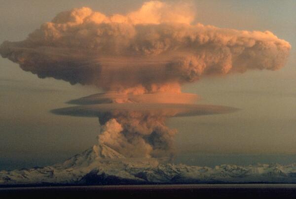
Redoubt Volcano
Ascending eruption cloud from Redoubt Volcano as viewed to the west from the Kenai Peninsula. The mushroom-shaped plume rose from avalanches of hot debris (pyroclastic flows) that cascaded down the north flank of the volcano. A smaller, white steam plume rises from the summit crater.
Ascending eruption cloud from Redoubt Volcano as viewed to the west from the Kenai Peninsula. The mushroom-shaped plume rose from avalanches of hot debris (pyroclastic flows) that cascaded down the north flank of the volcano. A smaller, white steam plume rises from the summit crater.

Augustine Volcano Sampling
Students climb out of ravine on north flank of Augustine Volcano during descent from sampling the 2006 lava flow during 2010 summer field campaign.
Students climb out of ravine on north flank of Augustine Volcano during descent from sampling the 2006 lava flow during 2010 summer field campaign.

Redoubt Volcano
Photo of Redoubt and vicinity taken from the gas/obs fixed-wing flight.
Photo of Redoubt and vicinity taken from the gas/obs fixed-wing flight.
Related
How often do Alaskan volcanoes erupt?
Alaskan volcanoes have produced one or two eruptions per year since 1900. At least 20 catastrophic caldera-forming eruptions have occurred in the past 10,000 years; the awesome eruption of 1912 at Novarupta in what is now Katmai National Park and Preserve is the most recent. Scientists are particularly concerned about the volcanoes whose eruptions can affect the Cook Inlet region, where 60 percent...
Can earthquakes trigger volcanic eruptions?
Sometimes, yes. A few large regional earthquakes (greater than magnitude 6) are considered to be related to a subsequent eruption or to some type of unrest at a nearby volcano. However, volcanoes can only be triggered into eruption by nearby tectonic earthquakes if they are already poised to erupt. This requires two conditions to be met: Enough "eruptible" magma within the volcanic system...
Why is it important to monitor volcanoes?
There are 161 potentially active volcanoes in the United States. According to a 2018 USGS assessment, 57 volcanoes are a high threat or very high threat to public safety. Many of these volcanoes have erupted in the recent past and will erupt again in the foreseeable future. As populations increase, areas near volcanoes are being developed and aviation routes are increasing. As a result, more...
Lava sampling: Why do we do it?
Hot lava samples provide important information about what's going on in a volcano's magma chambers. We know from laboratory experiments that the more magnesium there is in magma, the hotter it is. Chemical analysis, therefore, provides the means not only to determine the crystallization history of lava but also to establish the temperature at which it was erupted. For example, Kilauea's 1997 lavas...
Is it dangerous to work on volcanoes? What precautions do scientists take?
Volcanoes are inherently beautiful places where forces of nature combine to produce awesome events and spectacular landscapes. For volcanologists, they're FUN to work on! Safety is, however, always the primary concern because volcanoes can be dangerous places. USGS scientists try hard to understand the risk inherent in any situation, then train and equip themselves with the tools and support...
How can we tell when a volcano will erupt?
Most volcanoes provide warnings before an eruption. Magmatic eruptions involve the rise of magma toward the surface, which normally generates detectable earthquakes. It can also deform the ground surface and cause anomalous heat flow or changes in the temperature and chemistry of the groundwater and spring waters. Steam-blast eruptions, however, can occur with little or no warning as superheated...
How are volcanic gases measured?
Instruments to measure sulfur dioxide and carbon dioxide can be mounted in aircraft to determine the quantity of gas being emitted on a daily basis. Such instruments can also be used in a ground-based mode. An instrument that detects carbon dioxide can be installed on a volcano and configured to send data continuously via radio to an observatory. Sulfur dioxide in volcanic clouds can also be...
Can volcanic eruptions endanger helicopters and other aircraft?
Yes. Encounters between aircraft and clouds of volcanic ash are a serious concern. Jet engines and other aircraft components are vulnerable to damage by fine, abrasive volcanic ash, which can drift in dangerous concentrations hundreds of miles downwind from an erupting volcano. In the past, many aircraft have accidentally encountered volcanic ash clouds, and in some cases jet engines have...
Which volcanic eruptions were the deadliest?
Deadliest Volcanic Eruptions Since 1500 A.D. Eruption Year Casualties Major Cause Nevado del Ruiz, Colombia 1985 25,000 1,3 Mudflows 3 Mont Pelée, Martinique 1902 30,000 1 (29,025) 2 Pyroclastic flows 2 Krakatau, Indonesia 1883 36,000 1 (36,417) 2 Tsunami 2 Tambora, Indonesia 1815 92,000 1,2 Starvation 2 Unzendake, Japan 1792 15,000 1 (14,030) 2 Volcano collapse, Tsunami 2 Lakagigar (Laki)...
What was the largest volcanic eruption in the 20th century?
The world's largest eruption of the 20th century occurred in 1912 at Novarupta on the Alaska Peninsula in what is now Katmai National Park and Preserve. An estimated 15 cubic kilometers of magma was explosively erupted during 60 hours beginning on June 6th. This volume is equivalent to 230 years of eruption at Kilauea (Hawaii) or about 30 times the volume erupted by Mount St. Helens (Washington)...
Where does the United States rank in the number of volcanoes?
The United States ranks third, behind Indonesia and Japan, in the number of historically active volcanoes (that is, those for which we have written accounts of eruptions). In addition, about 10 percent of the more than 1,500 volcanoes that have erupted in the past 10,000 years are located in the United States. Most of these volcanoes are found in the Aleutian Islands, the Alaska Peninsula, the...
What was the most destructive volcanic eruption in the history of the United States?
The May 18, 1980 eruption of Mount St. Helens (Washington) was the most destructive in the history of the United States. Novarupta (Katmai) Volcano in Alaska erupted considerably more material in 1912, but owing to the isolation and sparse population of the region, there were no human deaths and little property damage. In contrast, the eruption of Mount St. Helens caused loss of lives and...
Annotated photo of Bogoslof Island showing effects of eruption
Annotated photograph of Bogoslof Island showing the cumulative effects of 2016-17 eruptive activity. A layer of fine muddy appearing ash drapes most of the landscape and covers pre-existing vegetation. The dashed line indicates the area excavated by explosive eruptive activity so far.
Annotated photograph of Bogoslof Island showing the cumulative effects of 2016-17 eruptive activity. A layer of fine muddy appearing ash drapes most of the landscape and covers pre-existing vegetation. The dashed line indicates the area excavated by explosive eruptive activity so far.
Satellite image of eruption cloud from Pavlof Volcano in November 2014
Satellite image from the USGS/NASA Landsat-8 satellite showing the eruption cloud at Pavlof Volcano on November 15 at 12:46 pm AKST (21:46 UTC). This is just a portion of the eruption cloud, which extended for more than 250 miles to the northwest at the time this image was collected.
Satellite image from the USGS/NASA Landsat-8 satellite showing the eruption cloud at Pavlof Volcano on November 15 at 12:46 pm AKST (21:46 UTC). This is just a portion of the eruption cloud, which extended for more than 250 miles to the northwest at the time this image was collected.
Aerial view toward the southwest of the actively erupting cone within Veniaminof caldera
Aerial view toward the southwest of the actively erupting cone within Veniaminof caldera. The white steam plume is produced where a lava flow is descending the side of the cone and melting snow and ice. The darker colored, ashy plume is rising in bursts from the active vent.
Aerial view toward the southwest of the actively erupting cone within Veniaminof caldera. The white steam plume is produced where a lava flow is descending the side of the cone and melting snow and ice. The darker colored, ashy plume is rising in bursts from the active vent.
Volcano Hazards
The United States has 169 active volcanoes. More than half of them could erupt explosively, sending ash up to 20,000 or 30,000 feet where commercial air traffic flies. USGS scientists are working to improve our understanding of volcano hazards to help protect communities and reduce the risks.
Video Sections:
The United States has 169 active volcanoes. More than half of them could erupt explosively, sending ash up to 20,000 or 30,000 feet where commercial air traffic flies. USGS scientists are working to improve our understanding of volcano hazards to help protect communities and reduce the risks.
Video Sections:
PubTalk 6/2012 — Exploring The Valley of Ten Thousand Smokes
-- a Centennial perspective of the Novarupta-Katmai eruption, the largest of the 20th century
By Judy Fierstein, USGS
-- a Centennial perspective of the Novarupta-Katmai eruption, the largest of the 20th century
By Judy Fierstein, USGS
Volcano Web Shorts 4 - Instruments
USGS technologist Rick LaHusen describes how the development and deployment of instruments plays a crucial role in mitigating volcanic hazards.
USGS technologist Rick LaHusen describes how the development and deployment of instruments plays a crucial role in mitigating volcanic hazards.
Volcano Web Shorts 5 - Volcanic Ash Impacts
Volcanic ash is geographically the most widespread of all volcanic hazards. USGS geologist Larry Mastin describes how volcanic ash can disrupt lives many thousands of miles from an erupting volcano. The development of ash cloud models and ash cloud disruption to air traffic is highlighted.
Volcanic ash is geographically the most widespread of all volcanic hazards. USGS geologist Larry Mastin describes how volcanic ash can disrupt lives many thousands of miles from an erupting volcano. The development of ash cloud models and ash cloud disruption to air traffic is highlighted.
PubTalk 12/2010 — Forecasting Volcanic Eruptions in Alaska
-- the contrasting stories of two recent spectacular eruptions
by Stephanie Prejean, USGS Alaska Volcano Observatory
-- the contrasting stories of two recent spectacular eruptions
by Stephanie Prejean, USGS Alaska Volcano Observatory
PubTalk 11/2009 — Geohazards in the Aleutian Islands
Great Earthquakes, Great Waves, and Great Volcanic Explosions!
by Steve Kirby, Geophsicist, and Dave Scholl, Scientist Emeritus
Great Earthquakes, Great Waves, and Great Volcanic Explosions!
by Steve Kirby, Geophsicist, and Dave Scholl, Scientist Emeritus
Helicopter Flight to Mount Redoubt
Scientists from the USGS Alaska Volcano Observatory (AVO) examine deposits on the lobe of the Drift Glacier with the summit of Mount Redoubt and its steaming lava dome in distance.
Scientists from the USGS Alaska Volcano Observatory (AVO) examine deposits on the lobe of the Drift Glacier with the summit of Mount Redoubt and its steaming lava dome in distance.
Shishaldin Volcano at Sunset
Shishaldin Volcano at sunset. Shishaldin is on Unimak Island, part of Izembek National Wildlife Refuge, Alaska.
Shishaldin Volcano at sunset. Shishaldin is on Unimak Island, part of Izembek National Wildlife Refuge, Alaska.
Scientist Captures thermal images of the Redoubt Lava Dome from Helicopter.
Kate Bull using a FLIR camera out the open door of an A-Star helicopter with the Redoubt summit and lava dome visible.
Kate Bull using a FLIR camera out the open door of an A-Star helicopter with the Redoubt summit and lava dome visible.
Redoubt Volcano viewed from the northwest following the April 4, 2009 eruption
Redoubt Volcano viewed from the northwest following the April 4, 2009 eruption (Event 19). Steam rises from the summit crater, pyroclastic flow and surge deposits drape the flanks, and lahar deposits cover the Drift River Valley.
Redoubt Volcano viewed from the northwest following the April 4, 2009 eruption (Event 19). Steam rises from the summit crater, pyroclastic flow and surge deposits drape the flanks, and lahar deposits cover the Drift River Valley.
A gas plume arising from Augustine Volcano during it's eruptive phase 2005-06.
A gas plume arising from Augustine Volcano during it's eruptive phase 2005-06. This photo was taken during a FLIR/maintenance flight on January 24, 2006.
A gas plume arising from Augustine Volcano during it's eruptive phase 2005-06. This photo was taken during a FLIR/maintenance flight on January 24, 2006.
Augustine Volcano
Augustine volcano viewed from the west.
Augustine volcano viewed from the west.
Mt. Spurr, Crater Peak
Roiling eruption column rising from Crater Peak vent of Mt. Spurr volcano. View from the south.
Roiling eruption column rising from Crater Peak vent of Mt. Spurr volcano. View from the south.
Valley of Ten Thousand Smokes, Alaska
View southeast from Overlook Cabin looking over the Valley of Ten Thousand Smokes. The pyroclastic and ash deposits that fill the valley remain nearly vegetation-free more than 100 years after the 1912 Novarupta-Katmai eruption.
View southeast from Overlook Cabin looking over the Valley of Ten Thousand Smokes. The pyroclastic and ash deposits that fill the valley remain nearly vegetation-free more than 100 years after the 1912 Novarupta-Katmai eruption.
Redoubt Volcano
Ascending eruption cloud from Redoubt Volcano as viewed to the west from the Kenai Peninsula. The mushroom-shaped plume rose from avalanches of hot debris (pyroclastic flows) that cascaded down the north flank of the volcano. A smaller, white steam plume rises from the summit crater.
Ascending eruption cloud from Redoubt Volcano as viewed to the west from the Kenai Peninsula. The mushroom-shaped plume rose from avalanches of hot debris (pyroclastic flows) that cascaded down the north flank of the volcano. A smaller, white steam plume rises from the summit crater.
Augustine Volcano Sampling
Students climb out of ravine on north flank of Augustine Volcano during descent from sampling the 2006 lava flow during 2010 summer field campaign.
Students climb out of ravine on north flank of Augustine Volcano during descent from sampling the 2006 lava flow during 2010 summer field campaign.
Redoubt Volcano
Photo of Redoubt and vicinity taken from the gas/obs fixed-wing flight.
Photo of Redoubt and vicinity taken from the gas/obs fixed-wing flight.
Updated Date: February 12, 2025