


- Yellowstone is one of a few dozen volcanoes on earth capable of "supereruptions" that expel more than 1,000 cubic km of ash and debris.
- The plumes from such eruptions can rise 30 to 50 km into the atmosphere, three to five times as high as most jets fly.
Can volcanic eruptions endanger helicopters and other aircraft?
Yes. Encounters between aircraft and clouds of volcanic ash are a serious concern. Jet engines and other aircraft components are vulnerable to damage by fine, abrasive volcanic ash, which can drift in dangerous concentrations hundreds of miles downwind from an erupting volcano.
In the past, many aircraft have accidentally encountered volcanic ash clouds, and in some cases jet engines have temporarily lost power. An international consortium of government agencies (including the USGS, the Federal Aviation Administration, and the National Weather Service), now monitors ash-producing volcanoes and tracks volcanic ash clouds to reduce the likelihood of future encounters.
Learn more: Airborne Volcanic Ash; A Global Threat to Aviation
Related
Can lakes near volcanoes become acidic enough to be dangerous to people and animals?
Yes. Crater lakes atop volcanoes are typically the most acid, with pH values as low as 0.1 (very strong acid). Normal lake waters, in contrast, have relatively neutral pH values near 7.0. The crater lake at El Chichon volcano in Mexico had a pH of 0.5 in 1983 and Mount Pinatubo's crater lake had a pH of 1.9 in 1992. The acid waters of these lakes are capable of causing burns to human skin but are...
Do volcanoes affect weather?
Yes, volcanoes can affect weather and the Earth's climate. Following the 1991 eruption of Mount Pinatubo in the Philippines, cooler than normal temperatures were recorded worldwide and brilliant sunsets and sunrises were attributed to this eruption that sent fine ash and gases high into the stratosphere, forming a large volcanic cloud that drifted around the world. The sulfur dioxide (SO2) in this...
How much ash was there from the May 18, 1980 eruption of Mount St. Helens?
During the 9 hours of vigorous eruptive activity on May 18, 1980, about 540 million tons of ash from Mount St. Helens fell over an area of more than 22,000 square miles (57,000 square kilometers). The total volume of the ash before its compaction by rainfall was about 0.3 cubic mile (1.3 cubic kilometers), equivalent to an area the size of a football field piled about 150 miles (240 kilometers)...
How far would ash travel if Yellowstone had a large explosive eruption?
Knowledge about past eruptions of Yellowstone combined with mathematical models of volcanic ash dispersion help scientists determine where and how much ashfall will occur in possible future eruptions. During the three caldera-forming eruptions that occurred between 2.1 million and 640,000 years ago, tiny particles of volcanic ash covered much of the western half of North America. That ash was...
How far did the ash from Mount St. Helens travel?
The May 18, 1980 eruptive column at Mount St. Helens fluctuated in height through the day, but the eruption subsided by late afternoon. By early May 19, the eruption had stopped. By that time, the ash cloud had spread to the central United States. Two days later, even though the ash cloud had become more diffuse, fine ash was detected by systems used to monitor air pollution in several cities of...
Does ash ever erupt from Kīlauea Volcano?
Kīlauea Volcano is renowned for its relatively benign eruptions of fluid lava flows. Therefore, many people were surprised by the small explosions that occurred in Halema`uma`u Crater in 2008 and 2018, and even more surprised to learn that volcanic ash was being erupted from a new gas vent. However, ash emissions from Halema`uma`u Crater are part of the volcano's legacy. Kīlauea's summit has...
What is "vog"? How is it related to sulfur dioxide (SO2) emissions?
Vog (volcanic smog) is a visible haze comprised of gas and an aerosol of tiny particles and acidic droplets created when sulfur dioxide (SO 2) and other gases emitted from a volcano chemically interact with sunlight and atmospheric oxygen, moisture, and dust. Volcanic gas emissions can pose environmental and health risks to nearby communities. Vog is a hazard that's associated with Hawaiian...
How dangerous are pyroclastic flows?
A pyroclastic flow is a hot (typically >800 °C, or >1,500 °F ), chaotic mixture of rock fragments, gas, and ash that travels rapidly (tens of meters per second) away from a volcanic vent or collapsing flow front. Pyroclastic flows can be extremely destructive and deadly because of their high temperature and mobility. For example, during the 1902 eruption of Mont Pelee in Martinique (West Indies)...
How Do Volcanoes Erupt?
Deep within the Earth it is so hot that some rocks slowly melt and become a thick flowing substance called magma. Since it is lighter than the solid rock around it, magma rises and collects in magma chambers. Eventually, some of the magma pushes through vents and fissures to the Earth's surface. Magma that has erupted is called lava. Some volcanic eruptions are explosive and others are not. The...
Which volcanic eruptions were the deadliest?
Deadliest Volcanic Eruptions Since 1500 A.D. Eruption Year Casualties Major Cause Nevado del Ruiz, Colombia 1985 25,000 1,3 Mudflows 3 Mont Pelée, Martinique 1902 30,000 1 (29,025) 2 Pyroclastic flows 2 Krakatau, Indonesia 1883 36,000 1 (36,417) 2 Tsunami 2 Tambora, Indonesia 1815 92,000 1,2 Starvation 2 Unzendake, Japan 1792 15,000 1 (14,030) 2 Volcano collapse, Tsunami 2 Lakagigar (Laki)...
What was the largest volcanic eruption in the 20th century?
The world's largest eruption of the 20th century occurred in 1912 at Novarupta on the Alaska Peninsula in what is now Katmai National Park and Preserve. An estimated 15 cubic kilometers of magma was explosively erupted during 60 hours beginning on June 6th. This volume is equivalent to 230 years of eruption at Kilauea (Hawaii) or about 30 times the volume erupted by Mount St. Helens (Washington)...

Forecasting Ashfall Impacts from a Yellowstone Supereruption
- Yellowstone is one of a few dozen volcanoes on earth capable of "supereruptions" that expel more than 1,000 cubic km of ash and debris.
- The plumes from such eruptions can rise 30 to 50 km into the atmosphere, three to five times as high as most jets fly.

Satellite image of eruption cloud from Pavlof Volcano in November 2014
Satellite image from the USGS/NASA Landsat-8 satellite showing the eruption cloud at Pavlof Volcano on November 15 at 12:46 pm AKST (21:46 UTC). This is just a portion of the eruption cloud, which extended for more than 250 miles to the northwest at the time this image was collected.
Satellite image from the USGS/NASA Landsat-8 satellite showing the eruption cloud at Pavlof Volcano on November 15 at 12:46 pm AKST (21:46 UTC). This is just a portion of the eruption cloud, which extended for more than 250 miles to the northwest at the time this image was collected.

Volcano Hazards
The United States has 169 active volcanoes. More than half of them could erupt explosively, sending ash up to 20,000 or 30,000 feet where commercial air traffic flies. USGS scientists are working to improve our understanding of volcano hazards to help protect communities and reduce the risks.
Video Sections:

Volcano Web Shorts 5 - Volcanic Ash Impacts
Volcanic ash is geographically the most widespread of all volcanic hazards. USGS geologist Larry Mastin describes how volcanic ash can disrupt lives many thousands of miles from an erupting volcano. The development of ash cloud models and ash cloud disruption to air traffic is highlighted.
Volcanic ash is geographically the most widespread of all volcanic hazards. USGS geologist Larry Mastin describes how volcanic ash can disrupt lives many thousands of miles from an erupting volcano. The development of ash cloud models and ash cloud disruption to air traffic is highlighted.

Volcano Web Shorts 4 - Instruments
USGS technologist Rick LaHusen describes how the development and deployment of instruments plays a crucial role in mitigating volcanic hazards.
USGS technologist Rick LaHusen describes how the development and deployment of instruments plays a crucial role in mitigating volcanic hazards.

Eyjafjallajökull Eruption
Photograph of the eruption from the summit of Eyjafjallajökull from the north looking to the south across the Gígjökull outlet glacier, its "missing" proglacial (ice-margin) lake caused by the jökulhlaup that filled in the lake.
Photograph of the eruption from the summit of Eyjafjallajökull from the north looking to the south across the Gígjökull outlet glacier, its "missing" proglacial (ice-margin) lake caused by the jökulhlaup that filled in the lake.

Public Lecture Sneak Peek: Geohazards of the Aleutian Islands -- Great Earthquakes, Great Waves, and Great Volcanic Explosions!
linkTo increase to increase public awareness during Native American Indian National Heritage Month, we will be discussing the anthropology of indigenous peoples in the Aleutian Islands and how continued scientific research can help future forecasting of mega-earthquake and transoceanic tsunami probabilities.

Ash-rich plume rises out of Halemaʻumaʻu Crater, Kilauea Volcano Hawaiʻi
Ash-rich plume rises out of Halemaʻumaʻu Crater, Kilauea Volcano Hawaiʻi.
Ash-rich plume rises out of Halemaʻumaʻu Crater, Kilauea Volcano Hawaiʻi.
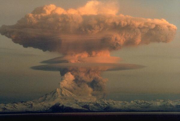
Redoubt Volcano
Ascending eruption cloud from Redoubt Volcano as viewed to the west from the Kenai Peninsula. The mushroom-shaped plume rose from avalanches of hot debris (pyroclastic flows) that cascaded down the north flank of the volcano. A smaller, white steam plume rises from the summit crater.
Ascending eruption cloud from Redoubt Volcano as viewed to the west from the Kenai Peninsula. The mushroom-shaped plume rose from avalanches of hot debris (pyroclastic flows) that cascaded down the north flank of the volcano. A smaller, white steam plume rises from the summit crater.

Katmai National Park and Preserve, Alaska
Volcanic ash drifts around houses at Katmai after the June 1912 eruption of Novarupta Volcano. Church in the distant background. August 13, 1912.
Volcanic ash drifts around houses at Katmai after the June 1912 eruption of Novarupta Volcano. Church in the distant background. August 13, 1912.
Related
Can lakes near volcanoes become acidic enough to be dangerous to people and animals?
Yes. Crater lakes atop volcanoes are typically the most acid, with pH values as low as 0.1 (very strong acid). Normal lake waters, in contrast, have relatively neutral pH values near 7.0. The crater lake at El Chichon volcano in Mexico had a pH of 0.5 in 1983 and Mount Pinatubo's crater lake had a pH of 1.9 in 1992. The acid waters of these lakes are capable of causing burns to human skin but are...
Do volcanoes affect weather?
Yes, volcanoes can affect weather and the Earth's climate. Following the 1991 eruption of Mount Pinatubo in the Philippines, cooler than normal temperatures were recorded worldwide and brilliant sunsets and sunrises were attributed to this eruption that sent fine ash and gases high into the stratosphere, forming a large volcanic cloud that drifted around the world. The sulfur dioxide (SO2) in this...
How much ash was there from the May 18, 1980 eruption of Mount St. Helens?
During the 9 hours of vigorous eruptive activity on May 18, 1980, about 540 million tons of ash from Mount St. Helens fell over an area of more than 22,000 square miles (57,000 square kilometers). The total volume of the ash before its compaction by rainfall was about 0.3 cubic mile (1.3 cubic kilometers), equivalent to an area the size of a football field piled about 150 miles (240 kilometers)...
How far would ash travel if Yellowstone had a large explosive eruption?
Knowledge about past eruptions of Yellowstone combined with mathematical models of volcanic ash dispersion help scientists determine where and how much ashfall will occur in possible future eruptions. During the three caldera-forming eruptions that occurred between 2.1 million and 640,000 years ago, tiny particles of volcanic ash covered much of the western half of North America. That ash was...
How far did the ash from Mount St. Helens travel?
The May 18, 1980 eruptive column at Mount St. Helens fluctuated in height through the day, but the eruption subsided by late afternoon. By early May 19, the eruption had stopped. By that time, the ash cloud had spread to the central United States. Two days later, even though the ash cloud had become more diffuse, fine ash was detected by systems used to monitor air pollution in several cities of...
Does ash ever erupt from Kīlauea Volcano?
Kīlauea Volcano is renowned for its relatively benign eruptions of fluid lava flows. Therefore, many people were surprised by the small explosions that occurred in Halema`uma`u Crater in 2008 and 2018, and even more surprised to learn that volcanic ash was being erupted from a new gas vent. However, ash emissions from Halema`uma`u Crater are part of the volcano's legacy. Kīlauea's summit has...
What is "vog"? How is it related to sulfur dioxide (SO2) emissions?
Vog (volcanic smog) is a visible haze comprised of gas and an aerosol of tiny particles and acidic droplets created when sulfur dioxide (SO 2) and other gases emitted from a volcano chemically interact with sunlight and atmospheric oxygen, moisture, and dust. Volcanic gas emissions can pose environmental and health risks to nearby communities. Vog is a hazard that's associated with Hawaiian...
How dangerous are pyroclastic flows?
A pyroclastic flow is a hot (typically >800 °C, or >1,500 °F ), chaotic mixture of rock fragments, gas, and ash that travels rapidly (tens of meters per second) away from a volcanic vent or collapsing flow front. Pyroclastic flows can be extremely destructive and deadly because of their high temperature and mobility. For example, during the 1902 eruption of Mont Pelee in Martinique (West Indies)...
How Do Volcanoes Erupt?
Deep within the Earth it is so hot that some rocks slowly melt and become a thick flowing substance called magma. Since it is lighter than the solid rock around it, magma rises and collects in magma chambers. Eventually, some of the magma pushes through vents and fissures to the Earth's surface. Magma that has erupted is called lava. Some volcanic eruptions are explosive and others are not. The...
Which volcanic eruptions were the deadliest?
Deadliest Volcanic Eruptions Since 1500 A.D. Eruption Year Casualties Major Cause Nevado del Ruiz, Colombia 1985 25,000 1,3 Mudflows 3 Mont Pelée, Martinique 1902 30,000 1 (29,025) 2 Pyroclastic flows 2 Krakatau, Indonesia 1883 36,000 1 (36,417) 2 Tsunami 2 Tambora, Indonesia 1815 92,000 1,2 Starvation 2 Unzendake, Japan 1792 15,000 1 (14,030) 2 Volcano collapse, Tsunami 2 Lakagigar (Laki)...
What was the largest volcanic eruption in the 20th century?
The world's largest eruption of the 20th century occurred in 1912 at Novarupta on the Alaska Peninsula in what is now Katmai National Park and Preserve. An estimated 15 cubic kilometers of magma was explosively erupted during 60 hours beginning on June 6th. This volume is equivalent to 230 years of eruption at Kilauea (Hawaii) or about 30 times the volume erupted by Mount St. Helens (Washington)...
Forecasting Ashfall Impacts from a Yellowstone Supereruption
- Yellowstone is one of a few dozen volcanoes on earth capable of "supereruptions" that expel more than 1,000 cubic km of ash and debris.
- The plumes from such eruptions can rise 30 to 50 km into the atmosphere, three to five times as high as most jets fly.
- Yellowstone is one of a few dozen volcanoes on earth capable of "supereruptions" that expel more than 1,000 cubic km of ash and debris.
- The plumes from such eruptions can rise 30 to 50 km into the atmosphere, three to five times as high as most jets fly.
Satellite image of eruption cloud from Pavlof Volcano in November 2014
Satellite image from the USGS/NASA Landsat-8 satellite showing the eruption cloud at Pavlof Volcano on November 15 at 12:46 pm AKST (21:46 UTC). This is just a portion of the eruption cloud, which extended for more than 250 miles to the northwest at the time this image was collected.
Satellite image from the USGS/NASA Landsat-8 satellite showing the eruption cloud at Pavlof Volcano on November 15 at 12:46 pm AKST (21:46 UTC). This is just a portion of the eruption cloud, which extended for more than 250 miles to the northwest at the time this image was collected.
Volcano Hazards
The United States has 169 active volcanoes. More than half of them could erupt explosively, sending ash up to 20,000 or 30,000 feet where commercial air traffic flies. USGS scientists are working to improve our understanding of volcano hazards to help protect communities and reduce the risks.
Video Sections:
The United States has 169 active volcanoes. More than half of them could erupt explosively, sending ash up to 20,000 or 30,000 feet where commercial air traffic flies. USGS scientists are working to improve our understanding of volcano hazards to help protect communities and reduce the risks.
Video Sections:
Volcano Web Shorts 5 - Volcanic Ash Impacts
Volcanic ash is geographically the most widespread of all volcanic hazards. USGS geologist Larry Mastin describes how volcanic ash can disrupt lives many thousands of miles from an erupting volcano. The development of ash cloud models and ash cloud disruption to air traffic is highlighted.
Volcanic ash is geographically the most widespread of all volcanic hazards. USGS geologist Larry Mastin describes how volcanic ash can disrupt lives many thousands of miles from an erupting volcano. The development of ash cloud models and ash cloud disruption to air traffic is highlighted.
Volcano Web Shorts 4 - Instruments
USGS technologist Rick LaHusen describes how the development and deployment of instruments plays a crucial role in mitigating volcanic hazards.
USGS technologist Rick LaHusen describes how the development and deployment of instruments plays a crucial role in mitigating volcanic hazards.
Eyjafjallajökull Eruption
Photograph of the eruption from the summit of Eyjafjallajökull from the north looking to the south across the Gígjökull outlet glacier, its "missing" proglacial (ice-margin) lake caused by the jökulhlaup that filled in the lake.
Photograph of the eruption from the summit of Eyjafjallajökull from the north looking to the south across the Gígjökull outlet glacier, its "missing" proglacial (ice-margin) lake caused by the jökulhlaup that filled in the lake.
Public Lecture Sneak Peek: Geohazards of the Aleutian Islands -- Great Earthquakes, Great Waves, and Great Volcanic Explosions!
linkTo increase to increase public awareness during Native American Indian National Heritage Month, we will be discussing the anthropology of indigenous peoples in the Aleutian Islands and how continued scientific research can help future forecasting of mega-earthquake and transoceanic tsunami probabilities.
Ash-rich plume rises out of Halemaʻumaʻu Crater, Kilauea Volcano Hawaiʻi
Ash-rich plume rises out of Halemaʻumaʻu Crater, Kilauea Volcano Hawaiʻi.
Ash-rich plume rises out of Halemaʻumaʻu Crater, Kilauea Volcano Hawaiʻi.
Redoubt Volcano
Ascending eruption cloud from Redoubt Volcano as viewed to the west from the Kenai Peninsula. The mushroom-shaped plume rose from avalanches of hot debris (pyroclastic flows) that cascaded down the north flank of the volcano. A smaller, white steam plume rises from the summit crater.
Ascending eruption cloud from Redoubt Volcano as viewed to the west from the Kenai Peninsula. The mushroom-shaped plume rose from avalanches of hot debris (pyroclastic flows) that cascaded down the north flank of the volcano. A smaller, white steam plume rises from the summit crater.
Katmai National Park and Preserve, Alaska
Volcanic ash drifts around houses at Katmai after the June 1912 eruption of Novarupta Volcano. Church in the distant background. August 13, 1912.
Volcanic ash drifts around houses at Katmai after the June 1912 eruption of Novarupta Volcano. Church in the distant background. August 13, 1912.
Updated Date: March 17, 2020