


A Record of Change—Science and Elder Observations on the Navajo Nation is a 25-minute documentary about collaborative studies using conventional physical sciences, combined with tribal elder observations to show that local knowledge and conventional science partnerships can effectively document ecosystem change and determine the resulting challenges to livelihoods.&
Why doesn't a drought end when it rains?
Rainfall in any form will provide some drought relief. A good analogy might be how medicine and illness relate to each other. A single dose of medicine can alleviate symptoms of illness, but it usually takes a sustained program of medication to cure an illness. Likewise, a single rainstorm will not break the drought, but it might provide temporary relief.
A light to moderate shower will probably only provide cosmetic relief; its impact is short term. Thunderstorms often produce large amounts of precipitation in a very short time, so most of the rain will run off into drainage channels and streams rather than soak into the ground.
Soaking rains are the best medicine to alleviate drought. Water that enters the soil recharges groundwater, which in turn sustains vegetation and feeds streams during periods of no rain. A single soaking rain will provide lasting relief from drought conditions, but multiple such rains over several months might be required to break a drought and return conditions to within the normal range.
Learn More: National Integrated Drought Information System (NIDIS) – Drought Basics
Related
What causes drought?
A drought is a period of drier-than-normal conditions that results in water-related problems. The amount of precipitation at a particular location varies from year to year, but over a period of years the average amount is fairly constant. In the deserts of the Southwest, the average precipitation is less than 3 inches per year. In contrast, the average precipitation in the Northwest is more than...
Where in the Nation are droughts or very low flows occurring now? How can I see these sites on a map and get to the data?
To view the USGS streamflow information on drought, see the drought map on our WaterWatch site, which shows below-normal, 7-day average streamflow compared to historical streamflow for the United States. Links to additional maps and drought data are listed on the USGS Drought website and the National Integrated Drought Information System (NIDIS).
When does a drought begin and end?
The beginning of a drought is difficult to determine. Several weeks, months, or even years might pass before people know that a drought is occurring. The end of a drought can occur as gradually as it began. The first evidence of drought is usually seen in records of rainfall. Within a short period of time, the amount of moisture in soils can begin to decrease. The effects of a drought on flow in...
What are the long-term effects of climate change?
Scientists have predicted that long-term effects of climate change will include a decrease in sea ice and an increase in permafrost thawing, an increase in heat waves and heavy precipitation, and decreased water resources in semi-arid regions. Below are some of the regional impacts of global change forecast by the Intergovernmental Panel on Climate Change: North America: Decreasing snowpack in the...
How can climate change affect natural disasters?
With increasing global surface temperatures the possibility of more droughts and increased intensity of storms will likely occur. As more water vapor is evaporated into the atmosphere it becomes fuel for more powerful storms to develop. More heat in the atmosphere and warmer ocean surface temperatures can lead to increased wind speeds in tropical storms. Rising sea levels expose higher locations...
What is the difference between global warming and climate change?
Although people tend to use these terms interchangeably, global warming is just one aspect of climate change. “Global warming” refers to the rise in global temperatures due mainly to the increasing concentrations of greenhouse gases in the atmosphere. “Climate change” refers to the increasing changes in the measures of climate over a long period of time – including precipitation, temperature, and...
What are some of the signs of climate change?
• Temperatures are rising world-wide due to greenhouse gases trapping more heat in the atmosphere. • Droughts are becoming longer and more extreme around the world. • Tropical storms becoming more severe due to warmer ocean water temperatures. • As temperatures rise there is less snowpack in mountain ranges and polar areas and the snow melts faster. • Overall, glaciers are melting at a faster rate...

A Record of Change: Science and Elder Observations on the Navajo N.
A Record of Change—Science and Elder Observations on the Navajo Nation is a 25-minute documentary about collaborative studies using conventional physical sciences, combined with tribal elder observations to show that local knowledge and conventional science partnerships can effectively document ecosystem change and determine the resulting challenges to livelihoods.&

Drought, Drinking Water and Natural Environments
This short video is one of a series of four total shorts highlighting USGS water science in California's Delta region. The Sacramento-San Joaquin Delta is the hub of the state's water system. Water quality touches on all aspects of life. Teams of U.S.
This short video is one of a series of four total shorts highlighting USGS water science in California's Delta region. The Sacramento-San Joaquin Delta is the hub of the state's water system. Water quality touches on all aspects of life. Teams of U.S.

Lake Mead Reaches Historic Low
The surface level of Lake Mead in Nevada and Arizona has fallen to a historic low as 16 years of ongoing drought in the American Southwest continue to impact the Colorado River Basin.
The surface level of Lake Mead in Nevada and Arizona has fallen to a historic low as 16 years of ongoing drought in the American Southwest continue to impact the Colorado River Basin.

USGS Documents 2015 Western U.S. Drought
A hydrologic technician from the USGS Idaho Water Science Center measures streamflow in Lightning Creek at Clark Fork, ID. The USGS is collecting data at hundreds of sites on rivers and streams in six western states to document the 2015 drought. USGS scientists will analyze the data to identify which rivers and streams may be most vulnerable to future droughts.
A hydrologic technician from the USGS Idaho Water Science Center measures streamflow in Lightning Creek at Clark Fork, ID. The USGS is collecting data at hundreds of sites on rivers and streams in six western states to document the 2015 drought. USGS scientists will analyze the data to identify which rivers and streams may be most vulnerable to future droughts.

Stillwater Creek in drought conditions
Stillwater Creek in drought conditions
Stillwater Creek in drought conditions

Drought and Beetle-Killed Piñon Pines in Arizona
Drought and beetle-killed piñon pines in Walnut Canyon National Monument near Flagstaff, Arizona, amid some surviving trees. Forest drought stress is highly correlated with mortality from poor growth, bark beetle outbreaks, and high-severity fire.
Drought and beetle-killed piñon pines in Walnut Canyon National Monument near Flagstaff, Arizona, amid some surviving trees. Forest drought stress is highly correlated with mortality from poor growth, bark beetle outbreaks, and high-severity fire.

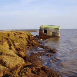
End of Dry Season
Dead molluscs and raccoon tracks are concentrated in cracks in mud in the substrate of a dried-down tidal pond. Increased frequency and duration of droughts are predicted by some climate models.
Dead molluscs and raccoon tracks are concentrated in cracks in mud in the substrate of a dried-down tidal pond. Increased frequency and duration of droughts are predicted by some climate models.

Vegetation Drought
The Vegetation Drought Response Index (VegDRI) incorporates satellite observations of vegetation to monitor at a finer spatial detail than other commonly used drought indicators.
The Vegetation Drought Response Index (VegDRI) incorporates satellite observations of vegetation to monitor at a finer spatial detail than other commonly used drought indicators.

California’s Hotter Drought and Tree Death
California's hotter drought has already killed millions of trees, particularly in low-elevation forests.
California's hotter drought has already killed millions of trees, particularly in low-elevation forests.

Related
What causes drought?
A drought is a period of drier-than-normal conditions that results in water-related problems. The amount of precipitation at a particular location varies from year to year, but over a period of years the average amount is fairly constant. In the deserts of the Southwest, the average precipitation is less than 3 inches per year. In contrast, the average precipitation in the Northwest is more than...
Where in the Nation are droughts or very low flows occurring now? How can I see these sites on a map and get to the data?
To view the USGS streamflow information on drought, see the drought map on our WaterWatch site, which shows below-normal, 7-day average streamflow compared to historical streamflow for the United States. Links to additional maps and drought data are listed on the USGS Drought website and the National Integrated Drought Information System (NIDIS).
When does a drought begin and end?
The beginning of a drought is difficult to determine. Several weeks, months, or even years might pass before people know that a drought is occurring. The end of a drought can occur as gradually as it began. The first evidence of drought is usually seen in records of rainfall. Within a short period of time, the amount of moisture in soils can begin to decrease. The effects of a drought on flow in...
What are the long-term effects of climate change?
Scientists have predicted that long-term effects of climate change will include a decrease in sea ice and an increase in permafrost thawing, an increase in heat waves and heavy precipitation, and decreased water resources in semi-arid regions. Below are some of the regional impacts of global change forecast by the Intergovernmental Panel on Climate Change: North America: Decreasing snowpack in the...
How can climate change affect natural disasters?
With increasing global surface temperatures the possibility of more droughts and increased intensity of storms will likely occur. As more water vapor is evaporated into the atmosphere it becomes fuel for more powerful storms to develop. More heat in the atmosphere and warmer ocean surface temperatures can lead to increased wind speeds in tropical storms. Rising sea levels expose higher locations...
What is the difference between global warming and climate change?
Although people tend to use these terms interchangeably, global warming is just one aspect of climate change. “Global warming” refers to the rise in global temperatures due mainly to the increasing concentrations of greenhouse gases in the atmosphere. “Climate change” refers to the increasing changes in the measures of climate over a long period of time – including precipitation, temperature, and...
What are some of the signs of climate change?
• Temperatures are rising world-wide due to greenhouse gases trapping more heat in the atmosphere. • Droughts are becoming longer and more extreme around the world. • Tropical storms becoming more severe due to warmer ocean water temperatures. • As temperatures rise there is less snowpack in mountain ranges and polar areas and the snow melts faster. • Overall, glaciers are melting at a faster rate...
A Record of Change: Science and Elder Observations on the Navajo N.
A Record of Change—Science and Elder Observations on the Navajo Nation is a 25-minute documentary about collaborative studies using conventional physical sciences, combined with tribal elder observations to show that local knowledge and conventional science partnerships can effectively document ecosystem change and determine the resulting challenges to livelihoods.&
A Record of Change—Science and Elder Observations on the Navajo Nation is a 25-minute documentary about collaborative studies using conventional physical sciences, combined with tribal elder observations to show that local knowledge and conventional science partnerships can effectively document ecosystem change and determine the resulting challenges to livelihoods.&
Drought, Drinking Water and Natural Environments
This short video is one of a series of four total shorts highlighting USGS water science in California's Delta region. The Sacramento-San Joaquin Delta is the hub of the state's water system. Water quality touches on all aspects of life. Teams of U.S.
This short video is one of a series of four total shorts highlighting USGS water science in California's Delta region. The Sacramento-San Joaquin Delta is the hub of the state's water system. Water quality touches on all aspects of life. Teams of U.S.
Lake Mead Reaches Historic Low
The surface level of Lake Mead in Nevada and Arizona has fallen to a historic low as 16 years of ongoing drought in the American Southwest continue to impact the Colorado River Basin.
The surface level of Lake Mead in Nevada and Arizona has fallen to a historic low as 16 years of ongoing drought in the American Southwest continue to impact the Colorado River Basin.
USGS Documents 2015 Western U.S. Drought
A hydrologic technician from the USGS Idaho Water Science Center measures streamflow in Lightning Creek at Clark Fork, ID. The USGS is collecting data at hundreds of sites on rivers and streams in six western states to document the 2015 drought. USGS scientists will analyze the data to identify which rivers and streams may be most vulnerable to future droughts.
A hydrologic technician from the USGS Idaho Water Science Center measures streamflow in Lightning Creek at Clark Fork, ID. The USGS is collecting data at hundreds of sites on rivers and streams in six western states to document the 2015 drought. USGS scientists will analyze the data to identify which rivers and streams may be most vulnerable to future droughts.
Stillwater Creek in drought conditions
Stillwater Creek in drought conditions
Stillwater Creek in drought conditions
Drought and Beetle-Killed Piñon Pines in Arizona
Drought and beetle-killed piñon pines in Walnut Canyon National Monument near Flagstaff, Arizona, amid some surviving trees. Forest drought stress is highly correlated with mortality from poor growth, bark beetle outbreaks, and high-severity fire.
Drought and beetle-killed piñon pines in Walnut Canyon National Monument near Flagstaff, Arizona, amid some surviving trees. Forest drought stress is highly correlated with mortality from poor growth, bark beetle outbreaks, and high-severity fire.
End of Dry Season
Dead molluscs and raccoon tracks are concentrated in cracks in mud in the substrate of a dried-down tidal pond. Increased frequency and duration of droughts are predicted by some climate models.
Dead molluscs and raccoon tracks are concentrated in cracks in mud in the substrate of a dried-down tidal pond. Increased frequency and duration of droughts are predicted by some climate models.
Vegetation Drought
The Vegetation Drought Response Index (VegDRI) incorporates satellite observations of vegetation to monitor at a finer spatial detail than other commonly used drought indicators.
The Vegetation Drought Response Index (VegDRI) incorporates satellite observations of vegetation to monitor at a finer spatial detail than other commonly used drought indicators.
California’s Hotter Drought and Tree Death
California's hotter drought has already killed millions of trees, particularly in low-elevation forests.
California's hotter drought has already killed millions of trees, particularly in low-elevation forests.
Updated Date: November 29, 2024