


Bill Schulz, USGS Research Geologist, takes photographs of Puerto Rican hillsides from a U.S. Army helicopter to document landslides caused by Hurricane Maria.
How can climate change affect natural disasters?
With increasing global surface temperatures the possibility of more droughts and increased intensity of storms will likely occur. As more water vapor is evaporated into the atmosphere it becomes fuel for more powerful storms to develop. More heat in the atmosphere and warmer ocean surface temperatures can lead to increased wind speeds in tropical storms. Rising sea levels expose higher locations not usually subjected to the power of the sea and to the erosive forces of waves and currents.
Related
Does an increase in the 100-year flood estimate originate from climate or land-use change?
Climate variability (dry cycles to wet cycles) and land-use change play a significant role, but there is a large amount of uncertainty around the flood quantile estimates (the value of discharge corresponding to the 100-year flood), particularly if there isn’t a long record of observed data at a stream location. Learn more: The 100-Year Flood The 100-Year Flood--It's All About Chance
What are the long-term effects of climate change?
Scientists have predicted that long-term effects of climate change will include a decrease in sea ice and an increase in permafrost thawing, an increase in heat waves and heavy precipitation, and decreased water resources in semi-arid regions. Below are some of the regional impacts of global change forecast by the Intergovernmental Panel on Climate Change: North America: Decreasing snowpack in the...
What is the difference between weather and climate change?
Weather refers to short term atmospheric conditions while climate is the weather of a specific region averaged over a long period of time. Climate change refers to long-term changes.
How do changes in climate and land use relate to one another?
The link between land use and the climate is complex. First, land cover--as shaped by land use practices--affects the global concentration of greenhouse gases. Second, while land use change is an important driver of climate change, a changing climate can lead to changes in land use and land cover. For example, farmers might shift from their customary crops to crops that will have higher economic...
How do we know the climate is changing?
The scientific community is certain that the Earth's climate is changing because of the trends that we see in the instrumented climate record and the changes that have been observed in physical and biological systems. The instrumental record of climate change is derived from thousands of temperature and precipitation recording stations around the world. We have very high confidence in these...
What are some of the signs of climate change?
• Temperatures are rising world-wide due to greenhouse gases trapping more heat in the atmosphere. • Droughts are becoming longer and more extreme around the world. • Tropical storms becoming more severe due to warmer ocean water temperatures. • As temperatures rise there is less snowpack in mountain ranges and polar areas and the snow melts faster. • Overall, glaciers are melting at a faster rate...
What is the difference between global warming and climate change?
Although people tend to use these terms interchangeably, global warming is just one aspect of climate change. “Global warming” refers to the rise in global temperatures due mainly to the increasing concentrations of greenhouse gases in the atmosphere. “Climate change” refers to the increasing changes in the measures of climate over a long period of time – including precipitation, temperature, and...
Why is climate change happening and what are the causes?
There are many “natural” and “anthropogenic” (human-induced) factors that contribute to climate change. Climate change has always happened on Earth, which is clearly seen in the geological record; it is the rapid rate and the magnitude of climate change occurring now that is of great concern worldwide. Greenhouse gases in the atmosphere absorb heat radiation. Human activity has increased...
What is the role of the USGS in responding to hurricanes?
The USGS creates detailed maps of our Nation’s shorelines, dunes, and coastal cliffs, and studies how storm processes impact our coastlines. This information is used to predict and map coastal vulnerability to changes caused by major storms, long-term shoreline erosion, sea-level rise, and sea cliff erosion. One example is the USGS Total Water Level and Coastal Change Forecast Viewer, which uses...

Documenting landslides in Puerto Rico caused by Hurricane Maria.
Bill Schulz, USGS Research Geologist, takes photographs of Puerto Rican hillsides from a U.S. Army helicopter to document landslides caused by Hurricane Maria.

USGS Hurricane Preparedness
Before a hurricane, USGS Scientists undertake a data collection effort of a grand scale. They install a temporary mobile network of sensors along the coasts to collect additional data on the intensity of storm surge, one of the most dangerous elements of a hurricane.
Before a hurricane, USGS Scientists undertake a data collection effort of a grand scale. They install a temporary mobile network of sensors along the coasts to collect additional data on the intensity of storm surge, one of the most dangerous elements of a hurricane.

USGS Storm-Tide Sensor installed for Hurricane Jose
A USGS specialist installs a storm-tide sensor in Massachusetts before Hurricane Jose's arrival.
A USGS specialist installs a storm-tide sensor in Massachusetts before Hurricane Jose's arrival.

Before and after pictures - Hurricane Rita and Holly Beach, Louisiana
Hurricanes can cause severe beach erosion
——————————————————————
Hurricanes can cause severe beach erosion
——————————————————————

Arctic bluff erosion
USGS is studying climate change impacts to U.S. Pacific and Arctic coasts. Alaska’s north coast is predominantly erosional, retreating on average about 1.4 meters per year.
USGS is studying climate change impacts to U.S. Pacific and Arctic coasts. Alaska’s north coast is predominantly erosional, retreating on average about 1.4 meters per year.

Drought, Drinking Water and Natural Environments
This short video is one of a series of four total shorts highlighting USGS water science in California's Delta region. The Sacramento-San Joaquin Delta is the hub of the state's water system. Water quality touches on all aspects of life. Teams of U.S.
This short video is one of a series of four total shorts highlighting USGS water science in California's Delta region. The Sacramento-San Joaquin Delta is the hub of the state's water system. Water quality touches on all aspects of life. Teams of U.S.

Hazards to California's Delta Water System
This short video is one of a series of four total shorts highlighting USGS water science in California's Delta region. Earthquakes, land subsidence and flooding pose significant threats to California’s fresh water. Aqueducts, pipes and sewer lines can break and levees can breach.
This short video is one of a series of four total shorts highlighting USGS water science in California's Delta region. Earthquakes, land subsidence and flooding pose significant threats to California’s fresh water. Aqueducts, pipes and sewer lines can break and levees can breach.

PubTalk 10/2015 — Fire-climate Relationships in the Sierra Nevada
Surprises relevant to future fire regime forecasts
by Jon E. Keeley, USGS Research Scientist
Surprises relevant to future fire regime forecasts
by Jon E. Keeley, USGS Research Scientist

Drought-related tree mortality in Sequoia National Park
Drought-related tree mortality at a low elevation forest in Sequoia National Park.
Drought-related tree mortality at a low elevation forest in Sequoia National Park.

USGS Documents 2015 Western U.S. Drought
A hydrologic technician from the USGS Idaho Water Science Center measures streamflow in Lightning Creek at Clark Fork, ID. The USGS is collecting data at hundreds of sites on rivers and streams in six western states to document the 2015 drought. USGS scientists will analyze the data to identify which rivers and streams may be most vulnerable to future droughts.
A hydrologic technician from the USGS Idaho Water Science Center measures streamflow in Lightning Creek at Clark Fork, ID. The USGS is collecting data at hundreds of sites on rivers and streams in six western states to document the 2015 drought. USGS scientists will analyze the data to identify which rivers and streams may be most vulnerable to future droughts.

Stillwater Creek in drought conditions
Stillwater Creek in drought conditions
Stillwater Creek in drought conditions

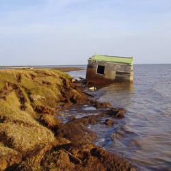
Susquehanna Floodwaters in Owego, NY 2011
USGS staffer in Susquehanna River floodwaters in Owego, NY 2011
USGS staffer in Susquehanna River floodwaters in Owego, NY 2011

USGS Public Lecture Series: Hurricanes and Our Changing Coasts
In September 2008, Hurricane Ike destroyed nearly every house in the Gulf-front community of Gilchrist, just north of Galveston Texas. In addition to storm surge and battering waves, the land on which the houses were built contributed to the disaster by changing in shape and elevation. Dr.
In September 2008, Hurricane Ike destroyed nearly every house in the Gulf-front community of Gilchrist, just north of Galveston Texas. In addition to storm surge and battering waves, the land on which the houses were built contributed to the disaster by changing in shape and elevation. Dr.

Vegetation Drought
The Vegetation Drought Response Index (VegDRI) incorporates satellite observations of vegetation to monitor at a finer spatial detail than other commonly used drought indicators.
The Vegetation Drought Response Index (VegDRI) incorporates satellite observations of vegetation to monitor at a finer spatial detail than other commonly used drought indicators.
Related
Does an increase in the 100-year flood estimate originate from climate or land-use change?
Climate variability (dry cycles to wet cycles) and land-use change play a significant role, but there is a large amount of uncertainty around the flood quantile estimates (the value of discharge corresponding to the 100-year flood), particularly if there isn’t a long record of observed data at a stream location. Learn more: The 100-Year Flood The 100-Year Flood--It's All About Chance
What are the long-term effects of climate change?
Scientists have predicted that long-term effects of climate change will include a decrease in sea ice and an increase in permafrost thawing, an increase in heat waves and heavy precipitation, and decreased water resources in semi-arid regions. Below are some of the regional impacts of global change forecast by the Intergovernmental Panel on Climate Change: North America: Decreasing snowpack in the...
What is the difference between weather and climate change?
Weather refers to short term atmospheric conditions while climate is the weather of a specific region averaged over a long period of time. Climate change refers to long-term changes.
How do changes in climate and land use relate to one another?
The link between land use and the climate is complex. First, land cover--as shaped by land use practices--affects the global concentration of greenhouse gases. Second, while land use change is an important driver of climate change, a changing climate can lead to changes in land use and land cover. For example, farmers might shift from their customary crops to crops that will have higher economic...
How do we know the climate is changing?
The scientific community is certain that the Earth's climate is changing because of the trends that we see in the instrumented climate record and the changes that have been observed in physical and biological systems. The instrumental record of climate change is derived from thousands of temperature and precipitation recording stations around the world. We have very high confidence in these...
What are some of the signs of climate change?
• Temperatures are rising world-wide due to greenhouse gases trapping more heat in the atmosphere. • Droughts are becoming longer and more extreme around the world. • Tropical storms becoming more severe due to warmer ocean water temperatures. • As temperatures rise there is less snowpack in mountain ranges and polar areas and the snow melts faster. • Overall, glaciers are melting at a faster rate...
What is the difference between global warming and climate change?
Although people tend to use these terms interchangeably, global warming is just one aspect of climate change. “Global warming” refers to the rise in global temperatures due mainly to the increasing concentrations of greenhouse gases in the atmosphere. “Climate change” refers to the increasing changes in the measures of climate over a long period of time – including precipitation, temperature, and...
Why is climate change happening and what are the causes?
There are many “natural” and “anthropogenic” (human-induced) factors that contribute to climate change. Climate change has always happened on Earth, which is clearly seen in the geological record; it is the rapid rate and the magnitude of climate change occurring now that is of great concern worldwide. Greenhouse gases in the atmosphere absorb heat radiation. Human activity has increased...
What is the role of the USGS in responding to hurricanes?
The USGS creates detailed maps of our Nation’s shorelines, dunes, and coastal cliffs, and studies how storm processes impact our coastlines. This information is used to predict and map coastal vulnerability to changes caused by major storms, long-term shoreline erosion, sea-level rise, and sea cliff erosion. One example is the USGS Total Water Level and Coastal Change Forecast Viewer, which uses...
Documenting landslides in Puerto Rico caused by Hurricane Maria.
Bill Schulz, USGS Research Geologist, takes photographs of Puerto Rican hillsides from a U.S. Army helicopter to document landslides caused by Hurricane Maria.
Bill Schulz, USGS Research Geologist, takes photographs of Puerto Rican hillsides from a U.S. Army helicopter to document landslides caused by Hurricane Maria.
USGS Hurricane Preparedness
Before a hurricane, USGS Scientists undertake a data collection effort of a grand scale. They install a temporary mobile network of sensors along the coasts to collect additional data on the intensity of storm surge, one of the most dangerous elements of a hurricane.
Before a hurricane, USGS Scientists undertake a data collection effort of a grand scale. They install a temporary mobile network of sensors along the coasts to collect additional data on the intensity of storm surge, one of the most dangerous elements of a hurricane.
USGS Storm-Tide Sensor installed for Hurricane Jose
A USGS specialist installs a storm-tide sensor in Massachusetts before Hurricane Jose's arrival.
A USGS specialist installs a storm-tide sensor in Massachusetts before Hurricane Jose's arrival.
Before and after pictures - Hurricane Rita and Holly Beach, Louisiana
Hurricanes can cause severe beach erosion
——————————————————————
Hurricanes can cause severe beach erosion
——————————————————————
Arctic bluff erosion
USGS is studying climate change impacts to U.S. Pacific and Arctic coasts. Alaska’s north coast is predominantly erosional, retreating on average about 1.4 meters per year.
USGS is studying climate change impacts to U.S. Pacific and Arctic coasts. Alaska’s north coast is predominantly erosional, retreating on average about 1.4 meters per year.
Drought, Drinking Water and Natural Environments
This short video is one of a series of four total shorts highlighting USGS water science in California's Delta region. The Sacramento-San Joaquin Delta is the hub of the state's water system. Water quality touches on all aspects of life. Teams of U.S.
This short video is one of a series of four total shorts highlighting USGS water science in California's Delta region. The Sacramento-San Joaquin Delta is the hub of the state's water system. Water quality touches on all aspects of life. Teams of U.S.
Hazards to California's Delta Water System
This short video is one of a series of four total shorts highlighting USGS water science in California's Delta region. Earthquakes, land subsidence and flooding pose significant threats to California’s fresh water. Aqueducts, pipes and sewer lines can break and levees can breach.
This short video is one of a series of four total shorts highlighting USGS water science in California's Delta region. Earthquakes, land subsidence and flooding pose significant threats to California’s fresh water. Aqueducts, pipes and sewer lines can break and levees can breach.
PubTalk 10/2015 — Fire-climate Relationships in the Sierra Nevada
Surprises relevant to future fire regime forecasts
by Jon E. Keeley, USGS Research Scientist
Surprises relevant to future fire regime forecasts
by Jon E. Keeley, USGS Research Scientist
Drought-related tree mortality in Sequoia National Park
Drought-related tree mortality at a low elevation forest in Sequoia National Park.
Drought-related tree mortality at a low elevation forest in Sequoia National Park.
USGS Documents 2015 Western U.S. Drought
A hydrologic technician from the USGS Idaho Water Science Center measures streamflow in Lightning Creek at Clark Fork, ID. The USGS is collecting data at hundreds of sites on rivers and streams in six western states to document the 2015 drought. USGS scientists will analyze the data to identify which rivers and streams may be most vulnerable to future droughts.
A hydrologic technician from the USGS Idaho Water Science Center measures streamflow in Lightning Creek at Clark Fork, ID. The USGS is collecting data at hundreds of sites on rivers and streams in six western states to document the 2015 drought. USGS scientists will analyze the data to identify which rivers and streams may be most vulnerable to future droughts.
Stillwater Creek in drought conditions
Stillwater Creek in drought conditions
Stillwater Creek in drought conditions
Susquehanna Floodwaters in Owego, NY 2011
USGS staffer in Susquehanna River floodwaters in Owego, NY 2011
USGS staffer in Susquehanna River floodwaters in Owego, NY 2011
USGS Public Lecture Series: Hurricanes and Our Changing Coasts
In September 2008, Hurricane Ike destroyed nearly every house in the Gulf-front community of Gilchrist, just north of Galveston Texas. In addition to storm surge and battering waves, the land on which the houses were built contributed to the disaster by changing in shape and elevation. Dr.
In September 2008, Hurricane Ike destroyed nearly every house in the Gulf-front community of Gilchrist, just north of Galveston Texas. In addition to storm surge and battering waves, the land on which the houses were built contributed to the disaster by changing in shape and elevation. Dr.
Vegetation Drought
The Vegetation Drought Response Index (VegDRI) incorporates satellite observations of vegetation to monitor at a finer spatial detail than other commonly used drought indicators.
The Vegetation Drought Response Index (VegDRI) incorporates satellite observations of vegetation to monitor at a finer spatial detail than other commonly used drought indicators.
Updated Date: April 14, 2025