
FORT Updates: From Plains to Peaks - Vol. 2 | Issue 8
Hot off the Press
Recent publications, events, and other news from the Fort Collins Science Center.
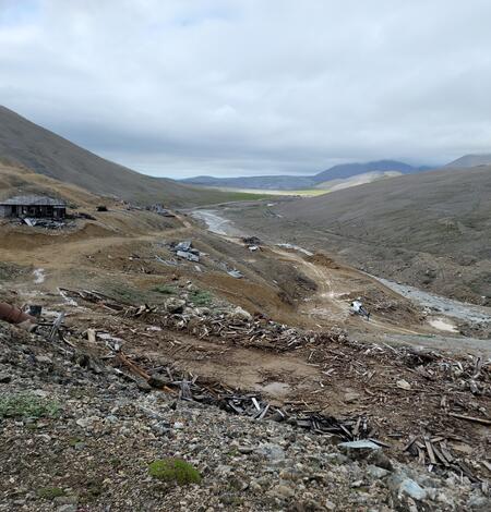
New USGS data-driven tools can aid restoration of mine lands across America
A suite of newly released tools can be used to help locate, study and restore mine lands.
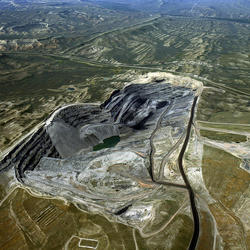
New USGS report describes potential uses of remote sensing for monitoring mine lands and mine land recovery
Mine lands are prevalent across the United States, and to monitor mines using solely on-the-ground measurements can be costly and time-consuming. In a new report funded by the Bipartisan Infrastructure Law, USGS researchers provide an overview of remote sensing and its use in assessing mine land recovery, while also highlighting the associated benefits and potential challenges.

Non-native plants consistently drive changes in functional traits of plant communities
Non-native plants have specific traits that cause consistent and predictable changes across ecosystems that can lead to wide-ranging changes in ecosystem function and associated ecosystem services. These are the findings of a new synthesis paper, published in the Proceedings of the National Academy of Science, September 19.

New publication estimates the effects of streamflow withdrawals on the Yampa river and its surrounding habitat
Rebecca Diehl, University of Vermont, and Jonathan Friedman, Fort Collins Science Center have published a report of model results quantifying effects of potential flow withdrawals on the riverine and riparian resources of the Yampa River in Dinosaur National Monument, Colorado.
Leveraging local habitat suitability models to enhance restoration benefits for species of conservation concern
Efforts to restore habitats and conserve wildlife species face many challenges that are exacerbated by limited funding and resources. Using Gunnison sage-grouse as a case study, researchers leveraged existing seasonal habitat models to identify areas of high restoration potential across landscapes with variable habitat conditions and habitat-use responses.

News
There is always something news worthy happening at the Fort Collins Science Center. Read below to learn more about our latest research, new advances in our fields of study, and topics that affect all of our lives.
Subscribe to our newsletter to get all the FORT Science Updates!
Science Spotlights
New or ongoing research projects at the Fort Collins Science Center.
-
INHABIT: A web-based decision support tool for invasive plant species habitat visualization and assessment across the contiguous United States
Many managers are hampered by the scope of the invasive species problem compared to their available resources. Habitat suitability models of invaders can help fill this resource gap, helping with activities such as watch list compilation and targeted surveillance and eradication efforts.Economics of Outdoor Recreation
Planning and managing outdoor recreation on public land and water entails a series of choices, many of which are economic in nature. Economics is useful for informing a wide range of decision-making processes in the context of outdoor recreation management, including why people choose to engage in recreation and where, how people substitute between different types of recreation activities and...Prioritizing Restoration of Sagebrush Ecosystems Tool (PReSET): A USGS-facilitated Decision-support Tool for Sagebrush Ecosystem Conservation and Restoration Actions
Sagebrush ecosystems represent one of the most imperiled systems in North America and face continued and widespread degradation due to multiple factors including climate change, invasive species, and increased human development. Effective sagebrush management must consider how to best conserve and restore habitats to stem the decline of species that rely on them, especially given limited...


Learn More
Find our science and connect with our researchers.

Publications
FORT scientists have produced more than 1,500 peer reviewed publications that are registered in the USGS Publications Warehouse, along with many others prior to their work at the USGS or in conjunction with other government agencies.

Data
Our interdisciplinary, integrated science teams develop various data sets in support of the USGS mission areas. This information then aids natural resource managers in decision making and support of the complex issues they face in today's world. The data and tools listed here are official USGS data releases.

Connect
The majority of our staff call Fort Collins, Colorado their home, but work all over the United States. FORT research and support staff work from one of four duty stations: in Colorado, at the Fort Collins Science Center or Denver Federal Center; in New Mexico, at the New Mexico Landscapes Field Station; or in Florida, at the USGS Everglades Research Offices.