
Geologist, sedimentation expert and Mars Science Laboratory team member David Rubin of the USGS Pacific Coastal and Marine Science Center investigates longitudinal dunes in China's Qaidam Basin. He comments: "The landscape has some similarity with Mars: almost total lack of vegetation and wind-formed landscape."
Images
Browse here for some of our available imagery. We may get permission to use some non-USGS images and these should be marked and are subject to copyright laws. USGS Astrogeology images can be freely downloaded.
Filter Total Items: 252

China's Qaidam Basin Landscape Similar with Mars
Geologist, sedimentation expert and Mars Science Laboratory team member David Rubin of the USGS Pacific Coastal and Marine Science Center investigates longitudinal dunes in China's Qaidam Basin. He comments: "The landscape has some similarity with Mars: almost total lack of vegetation and wind-formed landscape."

NASA Imagery S86-27256 (June, 1986): Artist’s concept of a lunar base
NASA Imagery S86-27256 (June, 1986): Artist’s concept of a lunar base.
NASA Imagery S86-27256 (June, 1986): Artist’s concept of a lunar base.

USGS IMAP 1659: Geologic map of the Michelangelo Quadrangle of Mercury
USGS IMAP 1659: Geologic map of the Michelangelo Quadrangle of Mercury
By: P. D. Spudis and J.G. Prosser
Map and associated documents are available through the USGS Publications Warehouse: https://doi.org/10.3133/i1659
USGS IMAP 1659: Geologic map of the Michelangelo Quadrangle of Mercury
By: P. D. Spudis and J.G. Prosser
Map and associated documents are available through the USGS Publications Warehouse: https://doi.org/10.3133/i1659

USGS IMAP 1233: Geologic map of the Kuiper Quadrangle of Mercury
USGS IMAP 1233: Geologic map of the Kuiper Quadrangle of Mercury
By: R.A. DeHon, D.H. Scott, and J.R. Underwood Jr.
Map and associated materials are available through the USGS Publications Warehouse: https://doi.org/10.3133/i1233
USGS IMAP 1233: Geologic map of the Kuiper Quadrangle of Mercury
By: R.A. DeHon, D.H. Scott, and J.R. Underwood Jr.
Map and associated materials are available through the USGS Publications Warehouse: https://doi.org/10.3133/i1233

USGS IMAP 1199: Geologic map of the Tolstoj Quadrangle of Mercury
USGS IMAP 1199: Geologic map of the Tolstoj Quadrangle of Mercury
By: G. G. Schaber and J.F. McCauley
Map and associated documents are available from the USGS Publications Warehouse: https://doi.org/10.3133/i1199
USGS IMAP 1199: Geologic map of the Tolstoj Quadrangle of Mercury
By: G. G. Schaber and J.F. McCauley
Map and associated documents are available from the USGS Publications Warehouse: https://doi.org/10.3133/i1199

USGS IMAP 1083: Geologic Map of Mars
USGS IMAP 1083: Geologic Map of Mars
By David H. Scott and Michael H. Carr
Map and associated documents are available from the USGS Publications Warehouse: https://doi.org/10.3133/i1083
USGS IMAP 1083: Geologic Map of Mars
By David H. Scott and Michael H. Carr
Map and associated documents are available from the USGS Publications Warehouse: https://doi.org/10.3133/i1083

INSET: USGS IMAP 1083: Geologic Map of Mars
Inset of USGS IMAP 1083: Geologic Map of Mars
By David H. Scott and Michael H. Carr
Map and associated documents are available from the USGS Publications Warehouse: https://doi.org/10.3133/i1083
Inset of USGS IMAP 1083: Geologic Map of Mars
By David H. Scott and Michael H. Carr
Map and associated documents are available from the USGS Publications Warehouse: https://doi.org/10.3133/i1083
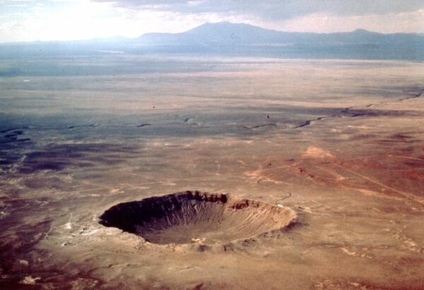
Aerial view of Meteor Crater, color, Coconino County, Arizona
Meteor Crater formed approximately 50,000 years ago by the impact of a 100,000-ton iron-nickel meteorite, ~30 m in diameter, which struck at an approximate speed of 12-20 km/sec.
Meteor Crater formed approximately 50,000 years ago by the impact of a 100,000-ton iron-nickel meteorite, ~30 m in diameter, which struck at an approximate speed of 12-20 km/sec.

Harrison 'Jack' Schmitt with the American Flag and Earth (Apollo 17)
Harrison H. Schmitt during the Apollo 17 mission.
Harrison H. Schmitt during the Apollo 17 mission.

USGS IMAP 800: Geologic maps of the Taurus-Littrow region of the Moon Apollo 17 pre-mission maps
linkUSGS IMAP 800: Geologic maps of the Taurus-Littrow region of the Moon Apollo 17 pre-mission maps
By: D.H. Scott, B.K. Lucchitta, and M.H. Carr
Map and associated documents are available from the USGS Publications Warehouse: https://doi.org/10.3133/i800

USGS IMAP 748: Geologic maps of the Descartes region of the Moon Apollo 16 pre-mission maps
USGS IMAP 748: Geologic maps of the Descartes region of the Moon Apollo 16 pre-mission maps
By: D.J. Milton and C.A. Hodges
Map and associated documents are available from the USGS Publications Warehouse: https://doi.org/10.3133/i748
USGS IMAP 748: Geologic maps of the Descartes region of the Moon Apollo 16 pre-mission maps
By: D.J. Milton and C.A. Hodges
Map and associated documents are available from the USGS Publications Warehouse: https://doi.org/10.3133/i748

USGS IMAP 703: Geologic map of the near side of the Moon
USGS IMAP 703: Geologic map of the near side of the Moon
By: D.E. Wilhelms and J.F. McCauley
Map details and associated PDFs are available at: https://doi.org/10.3133/i703
USGS IMAP 703: Geologic map of the near side of the Moon
By: D.E. Wilhelms and J.F. McCauley
Map details and associated PDFs are available at: https://doi.org/10.3133/i703

Harrison "Jack" Schmitt
Official NASA portrait of Apollo astronaut and former USGS geologist Harrison "Jack" Schmitt.
Official NASA portrait of Apollo astronaut and former USGS geologist Harrison "Jack" Schmitt.

USGS IMAP 723: Geologic maps of the Apennine-Hadley region of the Moon Apollo 15 pre-mission maps
linkUSGS IMAP 723: Geologic maps of the Apennine-Hadley region of the Moon Apollo 15 pre-mission maps
By: M.H. Carr, K.A. Howard, and F. El-Baz
Map and associated documents are available from the USGS Publications Warehouse: https://doi.org/10.3133/i723

USGS IMAP 624: Geologic map of the Wichmann CA region of the Moon
USGS IMAP 624: Geologic map of the Wichmann CA region of the Moon
By: D. Cummings
Map and associated documents are available from the USGS Publications Warehouse: https://doi.org/10.3133/i624
USGS IMAP 624: Geologic map of the Wichmann CA region of the Moon
By: D. Cummings
Map and associated documents are available from the USGS Publications Warehouse: https://doi.org/10.3133/i624

NASA Image AS15-92-12424
NASA image AS15-92-12424: Dave Scott’s photograph of Jim Irwin digging a trench to sample the lunar regolith during the second EVA of Apollo 15. The trench was dug down to the level at which it became much harder to remove.
NASA image AS15-92-12424: Dave Scott’s photograph of Jim Irwin digging a trench to sample the lunar regolith during the second EVA of Apollo 15. The trench was dug down to the level at which it became much harder to remove.

NASA Image AS15-92-12439
NASA Image AS15-92-12439: Dave Scott’s photographic documentation of the trench dug. Note the way the fine rock powder clumps together and can hold a vertical face.
NASA Image AS15-92-12439: Dave Scott’s photographic documentation of the trench dug. Note the way the fine rock powder clumps together and can hold a vertical face.

USGS IMAP 616: (ORB II-2 (100)) Geologic map of the Maskelyne DA region of the moon
USGS IMAP 616: (ORB II-2 (100)) Geologic map of the Maskelyne DA region of the moon
By: M.H. Carr
Map and associated documents are available from the USGS Publications Warehouse: https://doi.org/10.3133/i616
USGS IMAP 616: (ORB II-2 (100)) Geologic map of the Maskelyne DA region of the moon
By: M.H. Carr
Map and associated documents are available from the USGS Publications Warehouse: https://doi.org/10.3133/i616

Apollo Grover Historical Photo: B1
James Irwin(left) and David Scott(right) training in the Lunar Roving Vehicle training version known also known as the "Grover"
James Irwin(left) and David Scott(right) training in the Lunar Roving Vehicle training version known also known as the "Grover"

Mosaic of Mercury
A mosaic of the surface of Mercury made from hundreds of images taken by the MErcury Surface, Space ENvironment, GEochemistry and Ranging (MESSENGER) spacecraft.
A mosaic of the surface of Mercury made from hundreds of images taken by the MErcury Surface, Space ENvironment, GEochemistry and Ranging (MESSENGER) spacecraft.

Moon dirt simulant
In an unearthly series of events, the USGS has created man-made moon dirt, or regolith, to help NASA prepare for upcoming moon explorations. Four tons of the simulant is expected to be made by this summer of 2009 and turned over to the scientific community involved in lunar exploration.
In an unearthly series of events, the USGS has created man-made moon dirt, or regolith, to help NASA prepare for upcoming moon explorations. Four tons of the simulant is expected to be made by this summer of 2009 and turned over to the scientific community involved in lunar exploration.