
This image was taken by Left Navigation Camera onboard NASA's Mars rover Curiosity on Sol 3672. Credits: NASA/JPL-Caltech. Download image ›
Images
Browse here for some of our available imagery. We may get permission to use some non-USGS images and these should be marked and are subject to copyright laws. USGS Astrogeology images can be freely downloaded.
Filter Total Items: 252

9312_NLB_723480354EDR_F0982704NCAM00353M-web.jpg
This image was taken by Left Navigation Camera onboard NASA's Mars rover Curiosity on Sol 3672. Credits: NASA/JPL-Caltech. Download image ›

Kristen Bennett.jpg
Kristen Bennett is a planetary scientist who studies the geology of the Moon and Mars using NASA spacecraft.
Kristen Bennett is a planetary scientist who studies the geology of the Moon and Mars using NASA spacecraft.

Didymos Nomenclature
Image showing IAU-approved nomenclature for surface features on asteroid Didymos
Image showing IAU-approved nomenclature for surface features on asteroid Didymos

Dimorphos Nomenclature
Image showing IAU-approved nomenclature for surface features on asteroid Dimophos
Image showing IAU-approved nomenclature for surface features on asteroid Dimophos

Sonya Bogle
Staff profile photo for Sonya Bogle - photo is owned by Sonya Bogle and free for USGS use.
Staff profile photo for Sonya Bogle - photo is owned by Sonya Bogle and free for USGS use.

USGS SIM 3489: Geologic Map of MTM −10022 and −15022 Quadrangles, Morava Valles and Margaritifer Basin, Mars
linkUSGS SIM 3489: Geologic Map of MTM −10022 and −15022 Quadrangles, Morava Valles and Margaritifer Basin, Mars
By: Sharon A. Wilson, John A. Grant, and Kevin K. Williams
USGS SIM 3489: Geologic Map of MTM −10022 and −15022 Quadrangles, Morava Valles and Margaritifer Basin, Mars
linkUSGS SIM 3489: Geologic Map of MTM −10022 and −15022 Quadrangles, Morava Valles and Margaritifer Basin, Mars
By: Sharon A. Wilson, John A. Grant, and Kevin K. Williams

Virtual MRCTR
the Virtual MRCTR lab is available for GIS and planetary mapping support every Wednesday from 9 am - 12 pm pacific time
the Virtual MRCTR lab is available for GIS and planetary mapping support every Wednesday from 9 am - 12 pm pacific time

Curiosity Mars Rover Sol 3556: Left Navigation Camera
Originally posted on the raw images page for the Curiosity Mars rover. Description from that page: This image was taken by Left Navigation Camera onboard NASA's Mars rover Curiosity on Sol 3556 (2022-08-07 22:18:18 UTC).
Originally posted on the raw images page for the Curiosity Mars rover. Description from that page: This image was taken by Left Navigation Camera onboard NASA's Mars rover Curiosity on Sol 3556 (2022-08-07 22:18:18 UTC).

Curiosity: 10 Years of Martian Mountain Climbing
This image is the front of a poster made by NASA to commemorate the 10th anniversary of the Curiosity rover's landing on Mars. The original poster is available from NASA here.
NASA's original text is copied below:
This image is the front of a poster made by NASA to commemorate the 10th anniversary of the Curiosity rover's landing on Mars. The original poster is available from NASA here.
NASA's original text is copied below:

Curiosity on Sol 3536
Image from Left Navigation Camera onboard Curiosity, on Sol 3536. Image Credit: NASA/JPL-Caltech.
Image from Left Navigation Camera onboard Curiosity, on Sol 3536. Image Credit: NASA/JPL-Caltech.

CR0_709353878PRC_F0953152CCAM03512L1.png
This image was taken by Chemistry & Camera (ChemCam) onboard NASA's Mars rover Curiosity on Sol 3513 (2022-06-24 15:35:54 UTC).
This image was taken by Chemistry & Camera (ChemCam) onboard NASA's Mars rover Curiosity on Sol 3513 (2022-06-24 15:35:54 UTC).

FRB_709279749EDR_S0953152FHAZ00214M_.jpg
This image was taken by Front Hazard Avoidance Camera (Front Hazcam) onboard NASA's Mars rover Curiosity on Sol 3512 (2022-06-23 19:00:25 UTC).
This image was taken by Front Hazard Avoidance Camera (Front Hazcam) onboard NASA's Mars rover Curiosity on Sol 3512 (2022-06-23 19:00:25 UTC).

msss_03511_mhli_3511MH0004650011203954C00_DXXX.jpg
NASA's Mars rover Curiosity acquired this image using its Mars Hand Lens Imager (MAHLI), located on the turret at the end of the rover's robotic arm, on June 22, 2022, Sol 3511 of the Mars Science Laboratory Mission, at 16:46:15 UTC.
NASA's Mars rover Curiosity acquired this image using its Mars Hand Lens Imager (MAHLI), located on the turret at the end of the rover's robotic arm, on June 22, 2022, Sol 3511 of the Mars Science Laboratory Mission, at 16:46:15 UTC.

SandstoneTesting.jpg
In the photo, Glen, Greg, and Tim are monitoring the equipment. Under the cover, the thermal camera is observing the outcrop, with solar panels powering that camera and our computers.
In the photo, Glen, Greg, and Tim are monitoring the equipment. Under the cover, the thermal camera is observing the outcrop, with solar panels powering that camera and our computers.

Figure showing the potential dispersal of asteroid outfall from an impact in Colorado.
Figure from the Planetary Defense Conference Abstract showing the potential dispersal of asteroid outfall from an impact in Colorado.
Figure from the Planetary Defense Conference Abstract showing the potential dispersal of asteroid outfall from an impact in Colorado.

NV 17.jpg
Partial view of the "NightVisions: Cultural Interpretations of the Night Sky" exhibit in honor of Carolyn Shoemaker.
Partial view of the "NightVisions: Cultural Interpretations of the Night Sky" exhibit in honor of Carolyn Shoemaker.

Asteroid.png
Illustration of Earth (left) and asteroid Eros (right), with a starry space background. Photo Credit: NASA
Illustration of Earth (left) and asteroid Eros (right), with a starry space background. Photo Credit: NASA

A simple esker in Iceland
A simple esker that was recently exposed near the ice margin in Iceland.
A simple esker that was recently exposed near the ice margin in Iceland.

A complex esker system in Iceland
Lauren Edgar, a research geologist with the USGS Astrogeology Science Center, setting up a Terrestrial Laser Scanner (ground-based LiDAR) to acquire detailed topographic information for a complex esker system. The Breiðamerkurjökull glacier is visible in the background.
Lauren Edgar, a research geologist with the USGS Astrogeology Science Center, setting up a Terrestrial Laser Scanner (ground-based LiDAR) to acquire detailed topographic information for a complex esker system. The Breiðamerkurjökull glacier is visible in the background.

Lauren Edgar uses a hand lens to identify minerals in a sample from a complex esker.
Lauren Edgar, a research geologist with the USGS Astrogeology Science Center, uses a hand lens to identify minerals in a sample from a complex esker in Iceland.
Lauren Edgar, a research geologist with the USGS Astrogeology Science Center, uses a hand lens to identify minerals in a sample from a complex esker in Iceland.
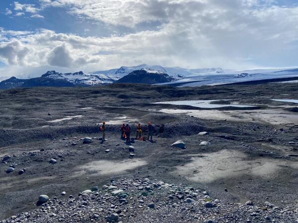
Researchers from the USGS, NASA, and NAU gather around a small simple esker and ephemeral lake deposits.
linkResearchers from the USGS, NASA, and NAU gather around a small simple esker and ephemeral lake deposits. The team used sedimentology, geochemistry, and remote sensing to characterize these features on Earth before comparing them to Mars.