
Flooding occurred on May 24 on Battle Creek below Keystone, SD. Heavy rains in western South Dakota caused flash flooding in parts of the Black Hills on May 24-26.
Images
Images intro.
Filter Total Items: 490

Battle Creek Flooding May 2015, SD
Flooding occurred on May 24 on Battle Creek below Keystone, SD. Heavy rains in western South Dakota caused flash flooding in parts of the Black Hills on May 24-26.

Battle Creek Flooding May 2015, SD
Following heavy rains, Battle Creek near Keystone (streamgage 06404000) peaked at about 1,500 cubic feet per second on May 24 and was about 1 foot below flood stage. This streamgage is operated in cooperation with the South Dakota Department of Natural Resources, Water Rights Division.
Following heavy rains, Battle Creek near Keystone (streamgage 06404000) peaked at about 1,500 cubic feet per second on May 24 and was about 1 foot below flood stage. This streamgage is operated in cooperation with the South Dakota Department of Natural Resources, Water Rights Division.

Grizzly Bear Creek Flooding May 2015, SD
Grizzly Bear Creek in Keystone, SD, on May 24, 2015. USGS streamgage 06403850 (Grizzly Bear Creek near Keystone, SD) showed the creek was more than one-half foot above flood stage on May 24.
Grizzly Bear Creek in Keystone, SD, on May 24, 2015. USGS streamgage 06403850 (Grizzly Bear Creek near Keystone, SD) showed the creek was more than one-half foot above flood stage on May 24.

White River Flooding near Kadoka, SD
Flooding on the White River near Kadoka, SD, streamgage 06447000. The gage house is left of center near hay bales. Streamflow at this site was measured by USGS as about 26,000 cubic feet per second on May 18, 2015. Major flooding on the White River in South Dakota occurred in May 2015 following snow and rain events in western South Dakota.
Flooding on the White River near Kadoka, SD, streamgage 06447000. The gage house is left of center near hay bales. Streamflow at this site was measured by USGS as about 26,000 cubic feet per second on May 18, 2015. Major flooding on the White River in South Dakota occurred in May 2015 following snow and rain events in western South Dakota.

White River Flooding near Kadoka, SD
Flooding on the White River near Kadoka, SD, streamgage 06447000. Streamflow at this site was measured by USGS as about 26,000 cubic feet per second on May 18, 2015. Major flooding on the White River in South Dakota occurred in May 2015 following snow and rain events in western South Dakota.
Flooding on the White River near Kadoka, SD, streamgage 06447000. Streamflow at this site was measured by USGS as about 26,000 cubic feet per second on May 18, 2015. Major flooding on the White River in South Dakota occurred in May 2015 following snow and rain events in western South Dakota.

White River Flooding near Kadoka, SD, May 18, 2015
Flooding on the White River near Kadoka, SD, streamgage 06447000. Streamflow at this site was measured by USGS as about 26,000 cubic feet per second on May 18, 2015. Major flooding on the White River in South Dakota occurred in May 2015 following snow and rain events in western South Dakota.
Flooding on the White River near Kadoka, SD, streamgage 06447000. Streamflow at this site was measured by USGS as about 26,000 cubic feet per second on May 18, 2015. Major flooding on the White River in South Dakota occurred in May 2015 following snow and rain events in western South Dakota.

Night Sky at Cheyenne River
Night sky at USGS streamgage 06408650, Cheyenne River near Scenic, SD.
Night sky at USGS streamgage 06408650, Cheyenne River near Scenic, SD.

Groundwater Outreach in Huron, SD
USGS Hydrologist Ryan Thompson demonstrated a groundwater model to a 4th grade class in Huron, SD, on April 2, 2015.
USGS Hydrologist Ryan Thompson demonstrated a groundwater model to a 4th grade class in Huron, SD, on April 2, 2015.

Soil and Groundwater Sampling
USGS Hydrologic Technician Brian Engle preparing to collect groundwater samples at EAFB FAC MW14_06 Fuels Area C, Ellsworth Air Force Base, South Dakota. In fall of 2013, the U.S. Geological Survey began a study in cooperation with the U.S.
USGS Hydrologic Technician Brian Engle preparing to collect groundwater samples at EAFB FAC MW14_06 Fuels Area C, Ellsworth Air Force Base, South Dakota. In fall of 2013, the U.S. Geological Survey began a study in cooperation with the U.S.

Soil and Groundwater Sampling
USGS Hydrologic Technician Brian Engle taking field measurments during groundwater sampling at EAFB FAC MW14_02 Fuels Area C, Ellsworth Air Force Base, South Dakota.In fall of 2013, the U.S. Geological Survey began a study in cooperation with the U.S.
USGS Hydrologic Technician Brian Engle taking field measurments during groundwater sampling at EAFB FAC MW14_02 Fuels Area C, Ellsworth Air Force Base, South Dakota.In fall of 2013, the U.S. Geological Survey began a study in cooperation with the U.S.

Soil and Groundwater Sampling
Groundwater sampling setup at EAFB FAC MW14_04 Fuels Area C, Ellsworth Air Force Base, South Dakota. In fall of 2013, the U.S. Geological Survey began a study in cooperation with the U.S.
Groundwater sampling setup at EAFB FAC MW14_04 Fuels Area C, Ellsworth Air Force Base, South Dakota. In fall of 2013, the U.S. Geological Survey began a study in cooperation with the U.S.

Earth Science Day outreach in Rapid City, SD, 2014
USGS student hydrologist Bill Eldridge demonstrates an interactive groundwater model to kids attending the Earth Science Day event on October 12, 2014, at the Journey Museum in Rapid City, SD.
USGS student hydrologist Bill Eldridge demonstrates an interactive groundwater model to kids attending the Earth Science Day event on October 12, 2014, at the Journey Museum in Rapid City, SD.
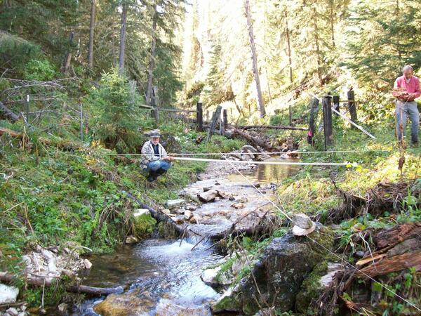
Slope-Area Measurements in Northern Black Hills, SD
USGS researchers running slope-area measurement in Ward Draw following storm of August 5, 2014. A group of thunderstorms produced greater than 4 inches of rain during four periods of progressively more intense rainfall across a small part of a relatively high-elevation area of the northern Black Hills on August 5, 2014.
USGS researchers running slope-area measurement in Ward Draw following storm of August 5, 2014. A group of thunderstorms produced greater than 4 inches of rain during four periods of progressively more intense rainfall across a small part of a relatively high-elevation area of the northern Black Hills on August 5, 2014.

Slope-Area Measurements in Northern Black Hills, SD
USGS researchers running slope-area measurement in Keough Draw following storm of August 5, 2014. A group of thunderstorms produced greater than 4 inches of rain during four periods of progressively more intense rainfall across a small part of a relatively high-elevation area of the northern Black Hills on August 5, 2014.
USGS researchers running slope-area measurement in Keough Draw following storm of August 5, 2014. A group of thunderstorms produced greater than 4 inches of rain during four periods of progressively more intense rainfall across a small part of a relatively high-elevation area of the northern Black Hills on August 5, 2014.

Stormwater Runoff in Rapid City, SD
Looking downstream at the 3rd Street wetland channel following an August 2014 runoff event in Rapid City, SD. Runoff from this wetland channel discharges into Rapid Creek.
Looking downstream at the 3rd Street wetland channel following an August 2014 runoff event in Rapid City, SD. Runoff from this wetland channel discharges into Rapid Creek.

Stormwater Runoff in Rapid City, SD
Automated sampler bottles containing stormwater runoff from the Arrowhead drainage basin in Rapid City, SD, being processed in the laboratory. Stormwater runoff from urbanized lands is known to harm surface-water resources by increasing stream velocities, destroying natural habitat, and increasing pollutant loads in the receiving waters.
Automated sampler bottles containing stormwater runoff from the Arrowhead drainage basin in Rapid City, SD, being processed in the laboratory. Stormwater runoff from urbanized lands is known to harm surface-water resources by increasing stream velocities, destroying natural habitat, and increasing pollutant loads in the receiving waters.

Soil and Groundwater Sampling
USGS Hydrologist David Bender using a photoionization detector on a split soil core from 15 to 20 feet for well EAFB FAC MW14_06, Fuels Area C, Ellsworth Air Force Base, South Dakota. The photoionization detector measures volatile organic compounds and other gases. In fall of 2013, the U.S. Geological Survey began a study in cooperation with the U.S.
USGS Hydrologist David Bender using a photoionization detector on a split soil core from 15 to 20 feet for well EAFB FAC MW14_06, Fuels Area C, Ellsworth Air Force Base, South Dakota. The photoionization detector measures volatile organic compounds and other gases. In fall of 2013, the U.S. Geological Survey began a study in cooperation with the U.S.

Soil and Groundwater Sampling, Ellsworth Air Force Base, SD
USGS Hydrologist, John Stamm, describing the split soil core for 20 to 25 feet from well EAFB FAC MW14_07, Fuels Area C, Ellsworth Air Force Base, South Dakota. In fall of 2013, the U.S. Geological Survey began a study in cooperation with the U.S.
USGS Hydrologist, John Stamm, describing the split soil core for 20 to 25 feet from well EAFB FAC MW14_07, Fuels Area C, Ellsworth Air Force Base, South Dakota. In fall of 2013, the U.S. Geological Survey began a study in cooperation with the U.S.

Soil and Groundwater Sampling
Drilling rig setup and drilling well EAFB FAC MW14_04 on Fuels Area C, Ellsworth Air Force Base, South Dakota. In fall of 2013, the U.S. Geological Survey began a study in cooperation with the U.S.
Drilling rig setup and drilling well EAFB FAC MW14_04 on Fuels Area C, Ellsworth Air Force Base, South Dakota. In fall of 2013, the U.S. Geological Survey began a study in cooperation with the U.S.

Rhoads Fork Near Rochford, SD
U.S. Geological Survey streamgage at Rhoads Fork near Rochford, South Dakota. Headwater springflow at the eastern edge of the Limestone Plateau provides flow to Rhoads Fork.
U.S. Geological Survey streamgage at Rhoads Fork near Rochford, South Dakota. Headwater springflow at the eastern edge of the Limestone Plateau provides flow to Rhoads Fork.

Ice Formation at Knife River at Manning, ND (06339100)
Ice formation looking upstream on the Knife River at Manning, North Dakota (U.S. Geological Survey streamgage 06339100;
Ice formation looking upstream on the Knife River at Manning, North Dakota (U.S. Geological Survey streamgage 06339100;