
A Landsat image after the Thomas fire in California in 2017. This image is to be used for the after image for a before and after image.
Images
Below are images associated with the Washington Water Science Center's science and staff. Images appear according to the year they were taken. To search, type a keyword or select a year from the dropdown menu. Or, click through the pages using the arrows at the bottom of the page.
Filter Total Items: 182

AfterThomas_Wildfires_Dec2017.jpg
A Landsat image after the Thomas fire in California in 2017. This image is to be used for the after image for a before and after image.

Measuring the Colville River at Kettle Falls, WA
USGS Hydrologic Technician Kim Cesal measuring 3170 cfs at 12409000 Colville River at Kettle Falls, WA. This measurement is the highest made at the gaging site. The gage has been in operation since October 1922. The gage was installed to monitor flows from Meyer Falls Dam and Power Generation.
USGS Hydrologic Technician Kim Cesal measuring 3170 cfs at 12409000 Colville River at Kettle Falls, WA. This measurement is the highest made at the gaging site. The gage has been in operation since October 1922. The gage was installed to monitor flows from Meyer Falls Dam and Power Generation.

Elwha River Mouth
Aerial photo by Tom Roorda of the mouth of the Elwha River near Port Angeles, Wash.
Aerial photo by Tom Roorda of the mouth of the Elwha River near Port Angeles, Wash.

Elwha River Salmon
A female Chinook salmon, among the first wave of fish to recolonize waters that haven't had salmon in 100 years, excavates a nest inside Olympic National Park.
A female Chinook salmon, among the first wave of fish to recolonize waters that haven't had salmon in 100 years, excavates a nest inside Olympic National Park.

Cableway measurement of flooding river
Cableways allow hydrologic technicians to safely measure streamflow. Here, a technician measures flood waters.
Cableways allow hydrologic technicians to safely measure streamflow. Here, a technician measures flood waters.

Measuring discharge in the Sauk River, Washington
A hydrologic technician wades across the Sauk River to measure streamflow at USGS streamgage 12186000. The staff gage in front of the boulder can be used to read the water level.
A hydrologic technician wades across the Sauk River to measure streamflow at USGS streamgage 12186000. The staff gage in front of the boulder can be used to read the water level.

Centrifuge Bowl Containing River Suspended Sediment for Analysis
A U.S. Geological Survey hydrologist holds a centrifuge bowl containing river suspended sediment for analysis of metals and organic chemicals. The sample was collected using a new in-field continuous-flow centrifugation technique to separate and collect suspended sediment from large volumes of water.
A U.S. Geological Survey hydrologist holds a centrifuge bowl containing river suspended sediment for analysis of metals and organic chemicals. The sample was collected using a new in-field continuous-flow centrifugation technique to separate and collect suspended sediment from large volumes of water.

The confluence of the Suiattle River (muddy river) into the Sauk River
The confluence of the Suiattle River (muddy river) into the Sauk River.
The confluence of the Suiattle River (muddy river) into the Sauk River.

Mount Rainier Looms over the Puyallup Valley, Washington
Mount Rainier volcano looms over Puyallup Valley, near Orting, Washington.
Mount Rainier volcano looms over Puyallup Valley, near Orting, Washington.

Elwha Crane Aerial Photo
This Sept. 26, 2012 image from a USGS unmanned aircraft shows the demolition of Glines Dam and Lake Mills on the Elwha River in Olympic National Park, Wash.
This Sept. 26, 2012 image from a USGS unmanned aircraft shows the demolition of Glines Dam and Lake Mills on the Elwha River in Olympic National Park, Wash.

Low-flow Discharge Measurement, Elwha River, Washington
USGS research ecologist Jeff Duda collects discharge data on a side channel of the Elwha River. Two large dams on the Elwha River are being incrementally removed from 2011 to 2013 to restore river function in an important salmon-bearing river.
USGS research ecologist Jeff Duda collects discharge data on a side channel of the Elwha River. Two large dams on the Elwha River are being incrementally removed from 2011 to 2013 to restore river function in an important salmon-bearing river.

Turbid Coastal Plume of the Elwha River, Washington
The turbid waters of the Elwha River and the coastal waters of the Strait of Juan de Fuca mix directly offshore of the river mouth, forming a large coastal plume. This plume is easily identified by the cloudiness of the water (or "turbidity") resulting from sediment discharged by the river. Two large dams on the Elwha River were incrementally r
The turbid waters of the Elwha River and the coastal waters of the Strait of Juan de Fuca mix directly offshore of the river mouth, forming a large coastal plume. This plume is easily identified by the cloudiness of the water (or "turbidity") resulting from sediment discharged by the river. Two large dams on the Elwha River were incrementally r

Turbid Coastal Plume of the Elwha River, Washington
The turbid waters of the Elwha River and the coastal waters of the Strait of Juan de Fuca mix directly offshore of the river mouth, forming a large coastal plume. This plume is easily identified by the cloudiness of the water (or "turbidity") resulting from sediment discharged by the river. Two large dams on the Elwha River are being incrementally r
The turbid waters of the Elwha River and the coastal waters of the Strait of Juan de Fuca mix directly offshore of the river mouth, forming a large coastal plume. This plume is easily identified by the cloudiness of the water (or "turbidity") resulting from sediment discharged by the river. Two large dams on the Elwha River are being incrementally r

Retrieving Sediment Instrumentation, Elwha River, Washington
USGS researchers Chris Curran and Raegan Huffman retrieve instrumentation to measure sediment concentration from the Elwha River, Washington. Two large dams on the Elwha River are being incrementally removed from 2011 to 2013 to restore river function in an important salmon-bearing river.
USGS researchers Chris Curran and Raegan Huffman retrieve instrumentation to measure sediment concentration from the Elwha River, Washington. Two large dams on the Elwha River are being incrementally removed from 2011 to 2013 to restore river function in an important salmon-bearing river.
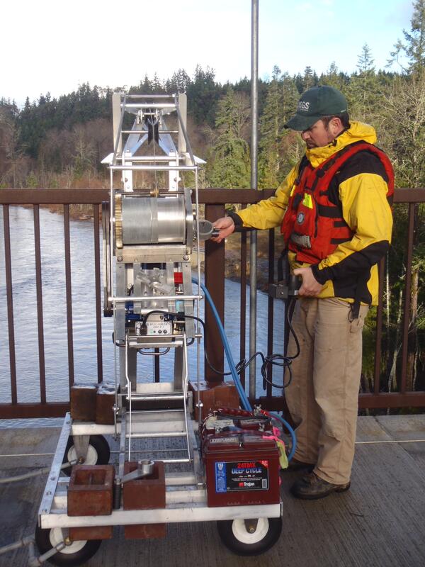
Operating Sediment-sampling Reel, Elwha River, Washington
USGS hydrologic technician James Foreman operates an electronic deployment reel from a bridge over the Elwha River, Washington. Two large dams on the Elwha River are being incrementally removed from 2011 to 2013 to restore river function in an important salmon-bearing river.
USGS hydrologic technician James Foreman operates an electronic deployment reel from a bridge over the Elwha River, Washington. Two large dams on the Elwha River are being incrementally removed from 2011 to 2013 to restore river function in an important salmon-bearing river.

River Otters in Olympic National Park, Wash.
River otters in Olympic National Park trigger a movement-activated camera without activating the wire mesh box trap (left) used by scientists to capture the animals to attach radio transmitters and monitor their movements.
River otters in Olympic National Park trigger a movement-activated camera without activating the wire mesh box trap (left) used by scientists to capture the animals to attach radio transmitters and monitor their movements.

Diver with Tape
USGS divers Steve Rubin and Reg Reisenbichler laying out a survey transect. Completing his 12th dive at the site in 2023, Rubin has been conducting dive surveys around the mouth of the Elwha River for over a decade as part of an evaluation of ecosystem health and recovery since the Elwha dams were breached in 2011.
USGS divers Steve Rubin and Reg Reisenbichler laying out a survey transect. Completing his 12th dive at the site in 2023, Rubin has been conducting dive surveys around the mouth of the Elwha River for over a decade as part of an evaluation of ecosystem health and recovery since the Elwha dams were breached in 2011.

Washington River
Beautiful River with Mount Rainier in the background
Beautiful River with Mount Rainier in the background

USGS divers in the Elwha River
USGS divers Steve Rubin and Reg Reisenbichler laying out a survey transect in the Elwha River in northern Washington.
USGS divers Steve Rubin and Reg Reisenbichler laying out a survey transect in the Elwha River in northern Washington.

High Water Mark Indicator
After floods, USGS scientists use indirect indicators to determine the extent and height of flooding. Debris caught on trees and fences is one such indicator.
After floods, USGS scientists use indirect indicators to determine the extent and height of flooding. Debris caught on trees and fences is one such indicator.

High Water Mark Survey
A USGS Technician attaches a high water marker to a tree. Debris wedged on the tree indicates the height that flood waters reached. A comprehensive survey of these markers allows scientists to determine the size of floods.
A USGS Technician attaches a high water marker to a tree. Debris wedged on the tree indicates the height that flood waters reached. A comprehensive survey of these markers allows scientists to determine the size of floods.