


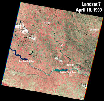
This pan sharpened color infrared image of Sioux Falls, South Dakota is from the first scene acquired by Landsat 7's Enhanced Thematic Mapper Plus (ETM+) sensor on April 18, 1999. The image is shown using the near infrared, red, and green bands (Bands 4,3,2).
Landsat 7
End of an era: Historic Landsat 7 mission takes final images
Retiring satellite makes way for upcoming enhanced science mission
Retiring satellite makes way for upcoming enhanced science mission
Landsat 7, launched April 15, 1999, introduced the Enhanced Thematic Mapper Plus, and a new panchromatic band to continue the legacy of Earth Observation.
The satellite acquired science data until January 19, 2024.

Sources/Usage: Public Domain. View Media Details
Landsat 7 was launched from Vandenberg Air Force Base in California on April 15, 1999 on a Delta II rocket. The satellite carried the Enhanced Thematic Mapper Plus (ETM+) sensor. This instrument was improved from previous instrumentation designs.
The primary features of the ETM+ sensor included a panchromatic band with 15 meter spatial resolution, an onboard full aperture solar calibrator, five percent absolute radiometric calibration, and a thermal infrared channel with a four-fold improvement in spatial resolution over earlier missions. Since June 2003, the sensor has acquired and delivered data with gaps caused by the Scan Line Corrector (SLC) failure.
In October 2008, USGS made all Landsat 7 data free to the global public; data downloads increased sixty-fold. About four months later, all Landsat data was made available at no cost.
In recognition of the 30th anniversary of the Landsat program in 2002, staff at USGS EROS selected some Landsat images to undergo creative enhancements. Forty of the most inspiring, beautiful satellite images were selected to be displayed in the online Earth as Art gallery. Several sets were framed and displayed in federal venues across the nation, including the underground hallways that connect the House and Senate office buildings in Washington, D.C. A part of the collection adorns the Mary W. Jackson NASA Headquarters’ walls, an honor usually reserved for manned spaceflight mission photos or Hubble Space Telescope images. There are now six Earth as Art Galleries available on the EROS website.
10th Anniversary of Free and Open Landsat Archives
10th Anniversary of Free and Open Landsat Archives
Landsat 7 Satellite Orbit Facts *
* These facts were applicable while the satellite was in nominal operations (April 1999 to May 2022); please review the Landsat 7 End of Life section below on this webpage for current status.
- Orbits the Earth at 705 km (438 mi) in a sun-synchronous, near-polar orbit (98.2 degrees inclination)
- Circles the Earth every 99 minutes
- Has a 16-day repeat cycle with an equatorial crossing time: 10:00 a.m. (+/- 15 minutes)
- Acquired on the Worldwide Reference System-2 (WRS-2) path/row system, with swath overlap (or sidelap) varying from 7 percent at the Equator to a maximum of approximately 85 percent at extreme latitudes
Landsat 7 Spacecraft Facts
- Power provided by a single Sun-tracking solar array and two 50 Ampere-Hour (AHr), Nickel Cadmium (NiCd) batteries
- Attitude control provided through four reaction wheels (pitch, yaw, roll, and skew); three 2-channel gyros with celestial drift updating; a static Earth sensor; a 1750 processor; and torque rods and magnetometers for momentum uploading
- Orbit control and backup momentum unloading provided through a blow-down monopropellant hydrazine system with a single tank containing 270 pounds of hydrazine, associated plumbing, and twelve 1-pound-thrust jets
- Weight: approx. 4,800 lbs (2,200 kg)
- Length: 4.3 m (14 ft)
- Diameter: 2.8 m (9 ft)
- Direct Downlink with Solid State Recorders (SSR)
- Data rate: 150 Mbps
Sources/Usage: Public Domain. View Media Details
Landsat 7 Enhanced Thematic Mapper Plus (ETM+) Instrument
Landsat 7 carried the Enhanced Thematic Mapper Plus (ETM+) sensor, an improved version of the Thematic Mapper instruments that were onboard Landsat 4 and Landsat 5. Landsat 7 products were delivered as 8-bit images with 256 grey levels. Descriptions of Landsat 7 band designations and comparisons of all Landsat sensors are available.
- The ETM+ contains eight spectral bands, including a pan and thermal band:
- Band 1 Blue (0.45 - 0.52 µm) 30 m
- Band 2 Green (0.52 - 0.60 µm) 30 m
- Band 3 Red (0.63 - 0.69 µm) 30 m
- Band 4 Near-Infrared (0.77 - 0.90 µm) 30 m
- Band 5 Short-wave Infrared (1.55 - 1.75 µm) 30 m
- Band 6 Thermal (10.40 - 12.50 µm) 60 m Low Gain / High Gain
- Band 7 Mid-Infrared (2.08 - 2.35 µm) 30 m
- Band 8 Panchromatic (PAN) (0.52 - 0.90 µm) 15 m
- Ground Sampling Interval (pixel size): 30 m reflective, 60 m thermal
- Added the Band 6 Low and High gain 60 m thermal bands
- On-board calibration was added to Landsat 7: a Full Aperture Solar Calibrator (FASC) and a Partial Aperture Solar Calibrator (PASC), in addition to the 2 calibration lamps
Landsat 7 Data Products
Landsat 7 data products are consistent with all Landsat standard data products, using the specifications described on the Landsat Processing Details page.
Landsat 7 Scan Line Corrector (SLC) Failure

Sources/Usage: Public Domain. View Media Details
On May 31, 2003, the Scan Line Corrector (SLC), which compensated for the forward motion of the satellite, failed. Subsequent efforts to recover the SLC were not successful, and the failure was permanent. Without an operating SLC, the sensor’s line of sight traced a zig-zag pattern along the satellite ground track.
As a result, the imaged area was duplicated, with a width that increased toward the edge of the scene. When the Level-1 data were processed, the duplicated areas were removed, leaving gaps. Even though there was data loss, 78 percent of the scene's pixels still remain after the duplicated areas were removed, and these data are still some of the most geometrically and radiometrically accurate of all civilian satellite data in the world.
Band-specific gap mask files are included with every Landsat 7 Scan Line Corrector (SLC)-off Level-1 data product. These ancillary data identify the location of all pixels affected by the original data gaps in the primary SLC-off scene. This webpage provides more details about these files: What are Landsat 7 SLC-off Gap Mask files.

Sources/Usage: Public Domain. View Media Details
A number of papers were written about the Landsat 7 Scan Line Corrector:
- Preliminary Assessment of the Value of Landsat 7 ETM+ Data Following Scan-Line Correction Malfunction. ( A summary of analysis done by the 1996-2001 Landsat Science Team)
- Landsat 7 Scan Line Corrector Processing Algorithm Theoretical Basis
- Landsat 7 SLC Gap-Filled Products Phase One Methodology
- Landsat 7 SLC-off Gap-Filled Products Phase Two Methodology
- Evaluation of L7 Gap-filled SLC-OFF Imagery for Burn Severity Mapping
Landsat 7 End of Mission Activities
Landsat 7 Extended Science Mission: May 5, 2022 - January 19, 2024
Landsat 7 imaging resumed on May 5, 2022, at a lower orbit of 697 km after a series of maneuvers in early April lowered the satellite out of the standard 705km WRS-2 orbit. The USGS elected to continue science data acquisition from the Enhanced Thematic Mapper Plus (ETM+) to assess the utility of imagery collected at the new lower orbit and earlier equatorial crossing time.
Since being lowered in orbit, the satellite has continued to drift within its orbit, exposing it to periods of full sunlight and earlier imaging times, impacting imaging opportunities and the ability to process valid science data. In January 2024, the satellite’s moved into full sunlight, which causes issues with the batteries. To retain the health and safety of the batteries, science imaging was suspended on January 19, 2024.
The Landsat 7 Extended Science Mission webpage describes the properties of the data, and activities done by Calibration/Validation and science teams to ensure the quality of the data remains nominal.
Note: The Product Identifier for each scene contains the acquisition date, so Landsat 7 scenes collected at the lower orbit can be identified by searching for Landsat 7 data acquired May 4, 2022 - January 19, 2024.
Nominal Science Mission Ends: April 6, 2022
On April 6, 2022, the ETM+ sensor was placed into “stand-by” mode as a series of spacecraft burns were performed throughout the month of April to lower the satellite’s orbit by 8 kilometers (see illustration below). After entering the lower orbit, the Landsat 7 satellite will be available for servicing by NASA's On-Orbit Servicing, Assembly, and Manufacturing-1 (OSAM-1) mission. OSAM-1 will provide Landsat 7 with the needed fuel for a successful decommissioning.

Sources/Usage: Public Domain. View Media Details
Final Inclination Maneuver: February 7, 2017
On February 7, 2017, the twentieth and final inclination (Delta-I) maneuver of Landsat 7 took place. (Delta-I maneuvers keep the spacecraft in the correct orbital position to ensure it maintains its 10:00 am ± 15 minutes mean local time (MLT) equatorial crossing.) Landsat 7 reached its peak outermost inclination boundary of 10:14:58 MLT on August 11, 2017. The chart below illustrates the inclination trend from June 2014 to June 2026. By the end of 2021, the satellite had a MLT of 9:00 am. This 2021 publication describes the research conducted into the science capability of Landsat 7 ETM+ data, while the satellite is drifting in orbit.

Sources/Usage: Public Domain. View Media Details
Landsat 7 Data User's Handbook
Additional Resources
Landsat 7 History (NASA Landsat)
The Enhanced Thematic Mapper (NASA Landsat)
The Living Legacy of Landsat 7: Still Going Strong after 20 Years in Orbit (NASA)
Landsat Archive Adds 10 Millionth Image (USGS)
Successful Maneuver Spells Beginning of the End for Landsat 7 (USGS)
Landsat 8 Underfly with Landsat 7: In March 2013, the Landsat 8 satellite was in position under Landsat 7 to collect near-coincident data for calibration activities.
Related Content

1999 Landsat 7 Launch
Landsat 7 was successfully launched on April 15, 1999, from the Western Test Range of Vandenberg Air Force Base, California, on a Delta II expendable launch vehicle. EROS History Project
Filter Total Items: 22

First Landsat 7 image of Sioux Falls, South Dakota
This pan sharpened color infrared image of Sioux Falls, South Dakota is from the first scene acquired by Landsat 7's Enhanced Thematic Mapper Plus (ETM+) sensor on April 18, 1999. The image is shown using the near infrared, red, and green bands (Bands 4,3,2).

End of an era: Historic Landsat 7 mission takes final images
RESTON, Va. — After more than 132,000 trips around the Earth and more than 3.3 million satellite images under its belt, the work of the Landsat 7 satellite is complete, even as the Landsat science mission continues with newer satellites.
Related Content
1999 Landsat 7 Launch
Landsat 7 was successfully launched on April 15, 1999, from the Western Test Range of Vandenberg Air Force Base, California, on a Delta II expendable launch vehicle. EROS History Project
Filter Total Items: 22
First Landsat 7 image of Sioux Falls, South Dakota
This pan sharpened color infrared image of Sioux Falls, South Dakota is from the first scene acquired by Landsat 7's Enhanced Thematic Mapper Plus (ETM+) sensor on April 18, 1999. The image is shown using the near infrared, red, and green bands (Bands 4,3,2).
This pan sharpened color infrared image of Sioux Falls, South Dakota is from the first scene acquired by Landsat 7's Enhanced Thematic Mapper Plus (ETM+) sensor on April 18, 1999. The image is shown using the near infrared, red, and green bands (Bands 4,3,2).
End of an era: Historic Landsat 7 mission takes final images
RESTON, Va. — After more than 132,000 trips around the Earth and more than 3.3 million satellite images under its belt, the work of the Landsat 7 satellite is complete, even as the Landsat science mission continues with newer satellites.