
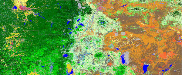
LANDFIRE Existing Vegetation Type imagery.
Images
Images intro.
Filter Total Items: 578
LANDFIRE- Landscape Fire and Resource Management Planning Tools
LANDFIRE Existing Vegetation Type imagery.

Mt. Kīlauea - July 2018
This image shows a lidar flight done in July 2018 of the Kīlauea volcano after the collapse of the caldera
This image shows a lidar flight done in July 2018 of the Kīlauea volcano after the collapse of the caldera


Survey Analysis via Visual Exploration rock cores
Survey Analysis via Visual Exploration rock cores
Survey Analysis via Visual Exploration rock cores

Kevin T. Gallagher at MAPPS Executive Summit on US lidar coverage
Kevin T. Gallagher, USGS Associate Director, Core Science Systems, addresses
Members of the MAPPS Executive Summit on US lidar coverage
Kevin T. Gallagher, USGS Associate Director, Core Science Systems, addresses
Members of the MAPPS Executive Summit on US lidar coverage

Natural oil seep along Tarwater Creek, San Mateo County, California
The natural oil seep in this photo is located in Pescadero Creek County Park, where the Canyon Trail crosses Tarwater Creek. The oil is black, has a taffy-like consistency, and smells like motor oil.
The natural oil seep in this photo is located in Pescadero Creek County Park, where the Canyon Trail crosses Tarwater Creek. The oil is black, has a taffy-like consistency, and smells like motor oil.

Simulated flooding, Denver, CO
A 3D Elevation Program lidar point cloud colored by RGB color from imagery from the National Agriculture Imagery Program and showing simulated flooding (in blue) of an area in Denver, Colorado.
A 3D Elevation Program lidar point cloud colored by RGB color from imagery from the National Agriculture Imagery Program and showing simulated flooding (in blue) of an area in Denver, Colorado.

Oil well pumping unit, Half Moon Bay oil field, California
The Half Moon Bay oil field is one of the oldest oil fields in California and was first developed during the 1880s. Since then, the field has produced an estimated 60,000 barrels of oil from about 19 wells.
The Half Moon Bay oil field is one of the oldest oil fields in California and was first developed during the 1880s. Since then, the field has produced an estimated 60,000 barrels of oil from about 19 wells.

South Dakota Landsat State Mosaic
South Dakota is home to the fabled “Black Hills.” Seen from a distance, these pine-covered hills, rising several thousand feet above the surrounding prairie, appear black.
Capital Pierre
Image Source Landsat 8
Population 886,667
South Dakota is home to the fabled “Black Hills.” Seen from a distance, these pine-covered hills, rising several thousand feet above the surrounding prairie, appear black.
Capital Pierre
Image Source Landsat 8
Population 886,667

Lidar point cloud over Dulles Airport
Lidar point cloud over Dulles Airport
Lidar point cloud over Dulles Airport

Lidar point cloud over Tacoma WA bridge
Lidar point cloud over Tacoma WA bridge
Lidar point cloud over Tacoma WA bridge

Lidar point cloud showing structures
An example of a lidar point cloud showing structures
An example of a lidar point cloud showing structures

Lidar point cloud of wind turbines in Kansas
Lidar point cloud of wind turbines in Kansas
Lidar point cloud of wind turbines in Kansas

Lidar point cloud of wind turbines in Texas
Lidar point cloud of wind turbines in Texas- QL2 data. Turbines were spinning as data was being collected.
Lidar point cloud of wind turbines in Texas- QL2 data. Turbines were spinning as data was being collected.

Lidar point cloud of the Statue of Liberty
Lidar point cloud of the Statue of Liberty
Lidar point cloud of the Statue of Liberty

3D view of Zion National Park DEM
3D view of Zion National Park DEM
3D view of Zion National Park DEM

3D view of Zion National Park DEM
3D view of Zion National Park DEM
3D view of Zion National Park DEM

Lidar point cloud of St Louis, MO
Lidar point cloud of St Louis, MO
Lidar point cloud of St Louis, MO

3D rendering outside Boulder, CO
3D rendering outside Boulder, CO. Overlay of 3DEP DEM and ortho imagery
3D rendering outside Boulder, CO. Overlay of 3DEP DEM and ortho imagery

Lidar point cloud over Washington, DC
Lidar point cloud over Washington, DC
Lidar point cloud over Washington, DC