
Staff profile photo of Eliza Malakoff. Eliza is a physical scientist with the Energy and Mineral Resources Mission Area.
Multimedia
Images

profile_picture_2.jpg.png
Staff profile photo of Eliza Malakoff. Eliza is a physical scientist with the Energy and Mineral Resources Mission Area.
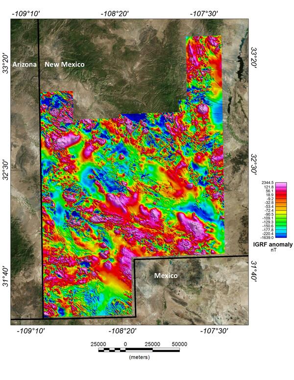
New Mexico porphyry copper belt aeromagnetic survey magnetic anomaly data
This image depicts the magnetic anomaly map of the region covered by the Southwest New Mexico aeromagnetic/aeroradiometric survey. These data allow us to model the subsurface structure and composition of the upper crust.
This image depicts the magnetic anomaly map of the region covered by the Southwest New Mexico aeromagnetic/aeroradiometric survey. These data allow us to model the subsurface structure and composition of the upper crust.

USGS critical mineral supply chain infographic
Infographic on USGS critical mineral supply chain analysis.
Minerals are essential to power homes and businesses and to manufacture products and technologies, from phones to vehicles.
Infographic on USGS critical mineral supply chain analysis.
Minerals are essential to power homes and businesses and to manufacture products and technologies, from phones to vehicles.

Saucer Shark Aeroshell and payload suspended by sling
USGS National Innovation Center UAS Research Center Saucer Shark Project, before science flight tests, Aeroshell and payload. Sling configuration and payload orientation verified before science flight deployment. Payload is on and ready to record!
USGS National Innovation Center UAS Research Center Saucer Shark Project, before science flight tests, Aeroshell and payload. Sling configuration and payload orientation verified before science flight deployment. Payload is on and ready to record!

BisonCore (MagEdition) displays live magnetic data (top) and lidar altitude (bottom)
USGS National Innovation Center UAS Research Center Saucer Shark Project, BisonCore displays the path of the sensor live, as it covers transects. Data received from the payload is then displayed within the BisonCore Ecosystem and is accessible for field viewing. The magnetic map is also used to validate payload directed algorithms.
USGS National Innovation Center UAS Research Center Saucer Shark Project, BisonCore displays the path of the sensor live, as it covers transects. Data received from the payload is then displayed within the BisonCore Ecosystem and is accessible for field viewing. The magnetic map is also used to validate payload directed algorithms.

USGS scientist examines a carbonatite dike in a mine pit
USGS scientist J. Poletti examines a carbonatite dike in the wall of the Mountain Pass mine pit.
USGS scientist J. Poletti examines a carbonatite dike in the wall of the Mountain Pass mine pit.
Videos
")
Escanaba Trough Expedition: Biological Communities (AD)
The familiar saying “good things come in small packages” holds especially true for deep-sea biological communities at hydrothermal vents, including those at Escanaba Trough, a seafloor spreading center located almost 200 miles off the northern California coast.
The familiar saying “good things come in small packages” holds especially true for deep-sea biological communities at hydrothermal vents, including those at Escanaba Trough, a seafloor spreading center located almost 200 miles off the northern California coast.
Escanaba Trough Expedition: Biological Communities
The familiar saying “good things come in small packages” holds especially true for deep-sea biological communities at hydrothermal vents, including those at Escanaba Trough, a seafloor spreading center located almost 200 miles off the northern California coast.
The familiar saying “good things come in small packages” holds especially true for deep-sea biological communities at hydrothermal vents, including those at Escanaba Trough, a seafloor spreading center located almost 200 miles off the northern California coast.

NOAA-USGS Stepping Stones 2021 Expedition - AD
Join USGS researchers Jason Chaytor and Kira Mizell as they virtually participate in a NOAA Ocean Exploration expedition to the depths of the North Atlantic.
Join USGS researchers Jason Chaytor and Kira Mizell as they virtually participate in a NOAA Ocean Exploration expedition to the depths of the North Atlantic.

USGS End of Year Accomplishments 2020
A 2020 year in review of the many accomplishments of the US Geological Survey. A year that began with seismic activity in Southwest Puerto Rico, to the first-ever public testing of USGS ShakeAlerts, USGS scientists and technicians helped to track storm data during the 2020 Atlantic Hurricane season.
A 2020 year in review of the many accomplishments of the US Geological Survey. A year that began with seismic activity in Southwest Puerto Rico, to the first-ever public testing of USGS ShakeAlerts, USGS scientists and technicians helped to track storm data during the 2020 Atlantic Hurricane season.

May the Quartz Be With You
As part of Earth Science Week 2020, USGS scientist Shannon Mahan takes us on a tour of quartz and how geologists like her use quartz to study all kinds of things, from earthquakes to archaeology.
As part of Earth Science Week 2020, USGS scientist Shannon Mahan takes us on a tour of quartz and how geologists like her use quartz to study all kinds of things, from earthquakes to archaeology.
")
Geologic Mapping at the USGS Florence Bascom Geoscience Center (AD)
The USGS Florence Bascom Geoscience Center (FBGC) is at the leading edge of scientific research addressing critical societal issues and providing unbiased data and information to decision makers and the public.
The USGS Florence Bascom Geoscience Center (FBGC) is at the leading edge of scientific research addressing critical societal issues and providing unbiased data and information to decision makers and the public.