
Staff profile photo of Eliza Malakoff. Eliza is a physical scientist with the Energy and Mineral Resources Mission Area.
Images
Images intro.
Filter Total Items: 283

profile_picture_2.jpg.png
Staff profile photo of Eliza Malakoff. Eliza is a physical scientist with the Energy and Mineral Resources Mission Area.
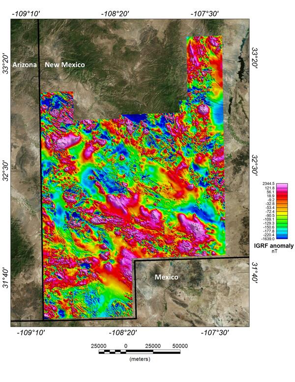
New Mexico porphyry copper belt aeromagnetic survey magnetic anomaly data
This image depicts the magnetic anomaly map of the region covered by the Southwest New Mexico aeromagnetic/aeroradiometric survey. These data allow us to model the subsurface structure and composition of the upper crust.
This image depicts the magnetic anomaly map of the region covered by the Southwest New Mexico aeromagnetic/aeroradiometric survey. These data allow us to model the subsurface structure and composition of the upper crust.

USGS critical mineral supply chain infographic
Infographic on USGS critical mineral supply chain analysis.
Minerals are essential to power homes and businesses and to manufacture products and technologies, from phones to vehicles.
Infographic on USGS critical mineral supply chain analysis.
Minerals are essential to power homes and businesses and to manufacture products and technologies, from phones to vehicles.

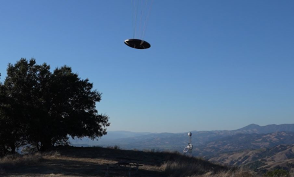
Saucer Shark Aeroshell and payload suspended by sling
USGS National Innovation Center UAS Research Center Saucer Shark Project, before science flight tests, Aeroshell and payload. Sling configuration and payload orientation verified before science flight deployment. Payload is on and ready to record!
USGS National Innovation Center UAS Research Center Saucer Shark Project, before science flight tests, Aeroshell and payload. Sling configuration and payload orientation verified before science flight deployment. Payload is on and ready to record!

BisonCore (MagEdition) displays live magnetic data (top) and lidar altitude (bottom)
USGS National Innovation Center UAS Research Center Saucer Shark Project, BisonCore displays the path of the sensor live, as it covers transects. Data received from the payload is then displayed within the BisonCore Ecosystem and is accessible for field viewing. The magnetic map is also used to validate payload directed algorithms.
USGS National Innovation Center UAS Research Center Saucer Shark Project, BisonCore displays the path of the sensor live, as it covers transects. Data received from the payload is then displayed within the BisonCore Ecosystem and is accessible for field viewing. The magnetic map is also used to validate payload directed algorithms.

USGS scientist examines a carbonatite dike in a mine pit
USGS scientist J. Poletti examines a carbonatite dike in the wall of the Mountain Pass mine pit.
USGS scientist J. Poletti examines a carbonatite dike in the wall of the Mountain Pass mine pit.

USGS hat on black bear berry
A USGS hat sits on a bed of black bear berry vegetation. This photo was taken in Kanuti, Alaska.
A USGS hat sits on a bed of black bear berry vegetation. This photo was taken in Kanuti, Alaska.

Saucer Shark Deployed Below UAV
USGS National Innovation Center UAS Research Center (UASRC) Saucer Shark Project, during flight tests, fully assembled. Sub assemblies from top down: Drop Release, Sling and Sling Brace, Payload Aeroshell and Payload.
USGS National Innovation Center UAS Research Center (UASRC) Saucer Shark Project, during flight tests, fully assembled. Sub assemblies from top down: Drop Release, Sling and Sling Brace, Payload Aeroshell and Payload.
Flying Saucer Shark Deployed over the skies of California
USGS National Innovation Center UAS Research Center Saucer Shark Project, during flight tests, aeroshell. Saucer Shark on landing approach after completed mission. Just above the landing pad.
USGS National Innovation Center UAS Research Center Saucer Shark Project, during flight tests, aeroshell. Saucer Shark on landing approach after completed mission. Just above the landing pad.

Saucer Shark Drop Release during testing campaign
USGS National Innovation Center UAS Research Center Saucer Shark Project, during flight tests, drop release attached to USGS UAV. Aircraft sits on landing pad in-between test flights.
USGS National Innovation Center UAS Research Center Saucer Shark Project, during flight tests, drop release attached to USGS UAV. Aircraft sits on landing pad in-between test flights.

Medicine Bow LLFA Survey Map
A map of the airborne geophysical survey area in the Medicine Mountains region of Wyoming
A map of the airborne geophysical survey area in the Medicine Mountains region of Wyoming

Mineral Systems Map of the United States
Maps showing parts of 23 mineral systems that could host critical mineral resources in the United States. These areas are used to prioritize data collection and analysis by Earth MRI.
Maps showing parts of 23 mineral systems that could host critical mineral resources in the United States. These areas are used to prioritize data collection and analysis by Earth MRI.

Montana
A view of the Boulder Mountains from US-12 west of Helena. These mountains lie at the north end of the Boulder Batholith.
A view of the Boulder Mountains from US-12 west of Helena. These mountains lie at the north end of the Boulder Batholith.

Space Economy Workshop Series
NASA and the United States Geological Survey (USGS) welcome the community to a series of Space Economy Workshops intended to coordinate the development of new technologies to detect and assess off-world mineral resources, as well as to discuss the challenges and opportunities for an off-world mineral resource economy.
NASA and the United States Geological Survey (USGS) welcome the community to a series of Space Economy Workshops intended to coordinate the development of new technologies to detect and assess off-world mineral resources, as well as to discuss the challenges and opportunities for an off-world mineral resource economy.

Aircraft with Geophysical Survey Equipment
A typical survey airplane. The magnetic sensor is placed in an extension on the back of the airplane to reduce the impact of the airplane’s own magnetic field.
A typical survey airplane. The magnetic sensor is placed in an extension on the back of the airplane to reduce the impact of the airplane’s own magnetic field.

Illinois River Basin low-level flight overview
This map shows the airborne geophysical survey area and planned flight paths across the Illinois River Basin in Illinois and northwest Indiana. Surveys will not occur directly above populated areas. Planned flight lines and survey progress can be found online.
(USGS map)
This map shows the airborne geophysical survey area and planned flight paths across the Illinois River Basin in Illinois and northwest Indiana. Surveys will not occur directly above populated areas. Planned flight lines and survey progress can be found online.
(USGS map)

Mountain Pass regional geologic map draped over topography
Geologic map overlaid on topography for the Mountain Pass region in California.
Geologic map overlaid on topography for the Mountain Pass region in California.

Pennington Mountain Critical Minerals Earth MRI Geophysical Scan
The anomaly at Pennington Mountain is visible in the geophysical data collected in aerial surveys conducted in 2021.
The anomaly at Pennington Mountain is visible in the geophysical data collected in aerial surveys conducted in 2021.

Pennington Mountain Rock with Critical Minerals
A fine-grained volcanic rock (trachyte) that hosts rare earth elements, niobium, and zirconium, all which are considered critical mineral resources. This rock was found on Pennington Mountain in Maine. Image courtesy of Chunzeng Wang, University of Maine-Presque Isle.
A fine-grained volcanic rock (trachyte) that hosts rare earth elements, niobium, and zirconium, all which are considered critical mineral resources. This rock was found on Pennington Mountain in Maine. Image courtesy of Chunzeng Wang, University of Maine-Presque Isle.

Piper Navajo fixed-wing aircraft with rear facing stinger magnetometer
A Piper Navajo fixed-wing aircraft with rear facing stinger magnetometer. Credit: New-Sense Geophysics Limited
A Piper Navajo fixed-wing aircraft with rear facing stinger magnetometer. Credit: New-Sense Geophysics Limited

Saucer Shark project equipment identifying marker
USGS NIC UASRC Saucer Shark equipment marker showing the Saucer flying over trees, with a ‘I WANT TO BELIEVE’ phrase below it.
USGS NIC UASRC Saucer Shark equipment marker showing the Saucer flying over trees, with a ‘I WANT TO BELIEVE’ phrase below it.