
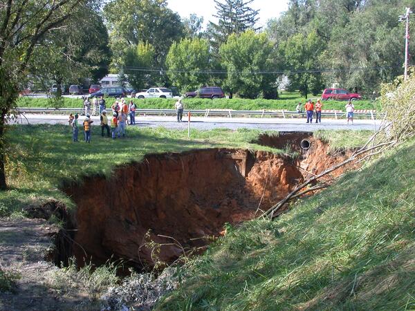
Collapse sinkhole in a salt dome in Daisetta, Texas (September 2008). Salt is particularly susceptible to rapid dissolution causing large bowl-shaped sinkholes. Injection of fluids into this salt dome increased the dissolution of the salt causing a 60-foot deep sinkhole that covered several acres and destroyed many buildings.
Images
Images intro.
Filter Total Items: 7147

Sinkhole in Daisetta, Texas
Collapse sinkhole in a salt dome in Daisetta, Texas (September 2008). Salt is particularly susceptible to rapid dissolution causing large bowl-shaped sinkholes. Injection of fluids into this salt dome increased the dissolution of the salt causing a 60-foot deep sinkhole that covered several acres and destroyed many buildings.
Sinkhole in Frederick, Maryland
Cover-collapse sinkhole in limestone near Frederick, Maryland (September 2003). Many sinkholes occur along highways where rainwater runoff is concentrated into storm drains and ditches increasing the rate of sinkhole development (note the sewer drain pipe beneath roadway).
Cover-collapse sinkhole in limestone near Frederick, Maryland (September 2003). Many sinkholes occur along highways where rainwater runoff is concentrated into storm drains and ditches increasing the rate of sinkhole development (note the sewer drain pipe beneath roadway).

Boulder from 2008 Great Sichuan Earthquake in China
The May 12, 2008, Great Sichuan Earthquake, also called the Wenchuan Earthquake, occurred at 14:28 local time, in Sichuan Province, China. The earthquake magnitudes were Mw = 7.9 (USGS), Ms = 8.0 (Chinese Earthquake Administration). The epicenter was 80 km west-northwest of Chengdu, the capital city of Sichuan province.
The May 12, 2008, Great Sichuan Earthquake, also called the Wenchuan Earthquake, occurred at 14:28 local time, in Sichuan Province, China. The earthquake magnitudes were Mw = 7.9 (USGS), Ms = 8.0 (Chinese Earthquake Administration). The epicenter was 80 km west-northwest of Chengdu, the capital city of Sichuan province.

2008 Landslide Near Hongyan Resort, China
The May 12, 2008, Great Sichuan Earthquake, also called the Wenchuan Earthquake, occurred at 14:28 local time, in Sichuan Province, China. The earthquake magnitudes were Mw = 7.9 (USGS), Ms = 8.0 (Chinese Earthquake Administration). The epicenter was 80 km west-northwest of Chengdu, the capital city of Sichuan province.
The May 12, 2008, Great Sichuan Earthquake, also called the Wenchuan Earthquake, occurred at 14:28 local time, in Sichuan Province, China. The earthquake magnitudes were Mw = 7.9 (USGS), Ms = 8.0 (Chinese Earthquake Administration). The epicenter was 80 km west-northwest of Chengdu, the capital city of Sichuan province.

Mameyes River Flood
The Mameyes River in flood. Eastern Puerto Rico.
The Mameyes River in flood. Eastern Puerto Rico.
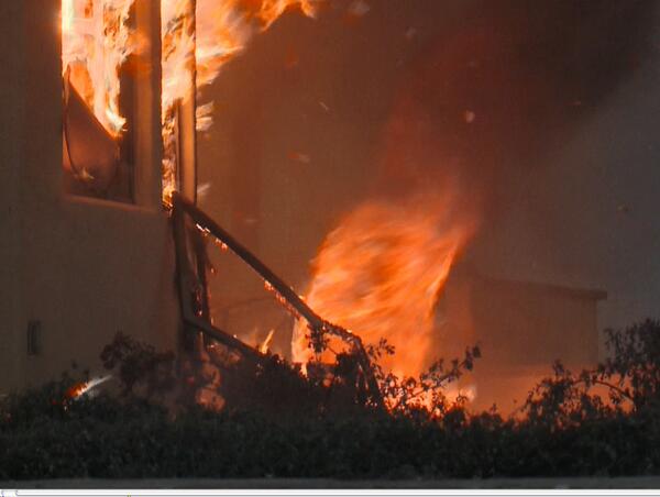
A Fire Tornado Swirls Near a Home in Southern California
A screenshot from the USGS film "Living with Fire".
A fire tornado swirls near a home in southern California. USGS is investigating the factors that dictate home loss from wildfires as part of the USGS Southern California Wildfire Risk Scenario Project.
Image courtesy of Tim Walton, Photo One Productions, CALFIRE. Shared with permission.

Road Damage from 2008 Great Sichuan Earthquake in China
The May 12, 2008, Great Sichuan Earthquake, also called the Wenchuan Earthquake, occurred at 14:28 local time, in Sichuan Province, China. The earthquake magnitudes were Mw = 7.9 (USGS), Ms = 8.0 (Chinese Earthquake Administration). The epicenter was 80 km west-northwest of Chengdu, the capital city of Sichuan province.
The May 12, 2008, Great Sichuan Earthquake, also called the Wenchuan Earthquake, occurred at 14:28 local time, in Sichuan Province, China. The earthquake magnitudes were Mw = 7.9 (USGS), Ms = 8.0 (Chinese Earthquake Administration). The epicenter was 80 km west-northwest of Chengdu, the capital city of Sichuan province.

House Damage from 2011 Central Virginia Earthquake
Damage to a house in Louisa County, Virginia, after a magnitude 5.8 earthquake on August 23, 2011.
Damage to a house in Louisa County, Virginia, after a magnitude 5.8 earthquake on August 23, 2011.

Aerial Oblique Photography Comparing the Chandeleur Islands Before and After Hurricane Isaac
The images reveal significant erosion of the island, likely due to inundation by waves and surge.This erosion resulted in the disappearance of an oil-protection berm constructed follow the BP oil spill. Due to this island's cumulative damage from previous storms like Hurricane Katrina, it remains in question whether this beach system will ever be able to fully
The images reveal significant erosion of the island, likely due to inundation by waves and surge.This erosion resulted in the disappearance of an oil-protection berm constructed follow the BP oil spill. Due to this island's cumulative damage from previous storms like Hurricane Katrina, it remains in question whether this beach system will ever be able to fully

Aerial Oblique Photography Comparing Dauphin Island Before and After Hurricane Isaac
Photos from Dauphin Island indicate beach erosion and island overwash, furthering the erosion the island has seen during repeated storm events -- Ivan, Katrina, Gustav and Isaac -- that have led to the island's increased vulnerability to future storms.
Photos from Dauphin Island indicate beach erosion and island overwash, furthering the erosion the island has seen during repeated storm events -- Ivan, Katrina, Gustav and Isaac -- that have led to the island's increased vulnerability to future storms.

House Damage from 2011 Central Virginia Earthquake
Damage to a house in Louisa County, Virginia, after a magnitude 5.8 earthquake on August 23, 2011.
Damage to a house in Louisa County, Virginia, after a magnitude 5.8 earthquake on August 23, 2011.

House Damage from 2011 Central Virginia Earthquake
Damage to a house in Louisa County, Virginia, after a magnitude 5.8 earthquake on August 23, 2011.
Damage to a house in Louisa County, Virginia, after a magnitude 5.8 earthquake on August 23, 2011.

House Damage from 2011 Central Virginia Earthquake
Chimney damage to a house in Louisa County, Virginia, after a magnitude 5.8 earthquake on August 23, 2011.
Chimney damage to a house in Louisa County, Virginia, after a magnitude 5.8 earthquake on August 23, 2011.

Floodwater at Wild Rice River
USGS personnel at work on bridge over Wild Rice River. Photo taken at 174th Ave and 124th St southwest of Horace, ND.
USGS personnel at work on bridge over Wild Rice River. Photo taken at 174th Ave and 124th St southwest of Horace, ND.

Floodwater at Wild Rice River
USGS personnel at work using acoustic doppler on bridge over Wild Rice River. Photo taken at 174th Ave and 124th St southwest of Horace, ND.
USGS personnel at work using acoustic doppler on bridge over Wild Rice River. Photo taken at 174th Ave and 124th St southwest of Horace, ND.

Floodwater at Wild Rice River
Acoustic doppler used to record measurements on Wild Rice River during 2010 flood. Photo taken from bridge at 174th Ave and 124th St southwest of Horace, ND.
Acoustic doppler used to record measurements on Wild Rice River during 2010 flood. Photo taken from bridge at 174th Ave and 124th St southwest of Horace, ND.

Floodwater at Wild Rice River
USGS personnel at work using acoustic doppler on bridge over Wild Rice River. Photo taken at 174th Ave and 124th St southwest of Horace, ND.
USGS personnel at work using acoustic doppler on bridge over Wild Rice River. Photo taken at 174th Ave and 124th St southwest of Horace, ND.

Mount Adams, aerial view from the south. The A.G. Aiken Lava Bed la...
Mount Adams, aerial view from the south. The A.G. Aiken Lava Bed lava flow is seen in the lower center of the photo, which erupted since the last glaciation.
Mount Adams, aerial view from the south. The A.G. Aiken Lava Bed lava flow is seen in the lower center of the photo, which erupted since the last glaciation.

Mount Adams from SW near Trout Lake, WA. Foreground surface is a 30...
Mount Adams from the southwest near Trout Lake, Washington. Foreground surface is a 300 year old lahar deposit that originated from high on the flank of the volcano, which deposited house-sized block.
Mount Adams from the southwest near Trout Lake, Washington. Foreground surface is a 300 year old lahar deposit that originated from high on the flank of the volcano, which deposited house-sized block.

Seismic monitoring station ASR at Mount Adams, WA
Seismic monitoring station ASR at Mount Adams, Washington. Scientist conducting routine maintenance.
Seismic monitoring station ASR at Mount Adams, Washington. Scientist conducting routine maintenance.