
(April 2, 2004, to October 28, 2006) A time-lapse camera was poised on the southwestern flank of Pu‘u ‘Ō‘ō cone from early 2004 through mid-2007.
All Multimedia
Access all multimedia to include images, video, audio, webcams, before-after imagery, and more. Filter and explore with filtering options to refine search.
Filter Total Items: 26026

Long-term Change at MLK Vent
(April 2, 2004, to October 28, 2006) A time-lapse camera was poised on the southwestern flank of Pu‘u ‘Ō‘ō cone from early 2004 through mid-2007.

PubTalk 10/2006 — The Parkfield 2004 Earthquake
Lessons From the Best-Recorded Quake in History
by Andy Michael, Geophysicist
Lessons From the Best-Recorded Quake in History
by Andy Michael, Geophysicist

Streamflow-gaging station 08096500 Brazos River at Waco
U.S. Geological Survey streamflow-gaging station 08096500 Brazos River at Waco, Texas, photograph looking upstream at the Brazos River (Lake Brazos) from the State Loop 340 bridge, October 25, 2006.
SIR 2009–5174
U.S. Geological Survey streamflow-gaging station 08096500 Brazos River at Waco, Texas, photograph looking upstream at the Brazos River (Lake Brazos) from the State Loop 340 bridge, October 25, 2006.
SIR 2009–5174

Active lava delta on south coast of Kīlauea, Hawai‘i
This lava delta at Lae‘apuki added about 24 hectares (60 acres) of new land to the southeast coast of Kīlauea in 2006, but 6.5 hectares (16 acres) slid into the sea in 2007. White plume marks location of lava entering the sea through a tube whose location is shown by blueish fume in middle right.
This lava delta at Lae‘apuki added about 24 hectares (60 acres) of new land to the southeast coast of Kīlauea in 2006, but 6.5 hectares (16 acres) slid into the sea in 2007. White plume marks location of lava entering the sea through a tube whose location is shown by blueish fume in middle right.

U.S. Geological Survey streamflow-gaging station 080305
U.S. Geological Survey streamflow-gaging station 08030500 Sabine River near Ruliff, Texas, photograph looking from left bank adjacent to State Highway 12 bridge, October 24, 2006.
SIR 2009–5174
U.S. Geological Survey streamflow-gaging station 08030500 Sabine River near Ruliff, Texas, photograph looking from left bank adjacent to State Highway 12 bridge, October 24, 2006.
SIR 2009–5174

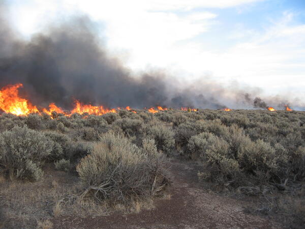
Burning Sagebrush
This is sagebrush burning at Hart Mountain National Antelope Refuge in association with a management project located 65 miles northeast of Lakeview, OR.
This is sagebrush burning at Hart Mountain National Antelope Refuge in association with a management project located 65 miles northeast of Lakeview, OR.

Controlled burn at Hart Mountain National Wildlife Refuge
controlled burn at Hart Mountain National Wildlife Refuge
controlled burn at Hart Mountain National Wildlife Refuge
Controlled burn at Hart Mountain National Wildlife Refuge.
Wildfire is one of the largest sources of re-released mercury to the atmosphere and a component to the widespread movement of inorganic mercury to aquatic sediments.
Wildfire is one of the largest sources of re-released mercury to the atmosphere and a component to the widespread movement of inorganic mercury to aquatic sediments.

Sagebrush on fire in a controlled burn
Controlled burn at Hart Mountain National Wildlife Refuge, Oregon.
Controlled burn at Hart Mountain National Wildlife Refuge, Oregon.

East Lae‘apuki shatter ring
October 16 , 2006, 06:20:23 to 08:00:22) This is another movie showing a shatter ring in action (see "Shatter ring on the PKK lava tube", 03-20-06).
October 16 , 2006, 06:20:23 to 08:00:22) This is another movie showing a shatter ring in action (see "Shatter ring on the PKK lava tube", 03-20-06).
")
East Lae'apuki Shatter Ring (October 16, 2006)
The lava-tube feature seen here is called a shatter ring. Shatter rings are circular to elliptical volcanic features, typically tens of meters (yards) in diameter, which form over active lava tubes. They are typified by an upraised rim of blocky rubble and a central depression.
The lava-tube feature seen here is called a shatter ring. Shatter rings are circular to elliptical volcanic features, typically tens of meters (yards) in diameter, which form over active lava tubes. They are typified by an upraised rim of blocky rubble and a central depression.

Collecting DC resistivity data to define subsurface gravel channels
Collecting DC resistivity data to define subsurface gravel channels. Bakken Formation of North Dakota.
Collecting DC resistivity data to define subsurface gravel channels. Bakken Formation of North Dakota.

Brewer's Sparrow Surveys
Conducing Brewer's sparrow (Spizella breweri) surveys in sagebrush habitat, Owyhee Moutains, SW Idaho.
Conducing Brewer's sparrow (Spizella breweri) surveys in sagebrush habitat, Owyhee Moutains, SW Idaho.

View of a cabin across a lake with bright blue sky.
Photo of Isle Royale National park, Michigan, across an inlet, with rocky headland, blue lake water, and cabin on the opposite shore.
Photo of Isle Royale National park, Michigan, across an inlet, with rocky headland, blue lake water, and cabin on the opposite shore.

Costa's Hummingbird (Calypte costae)
Costa's hummingbird perched on twig.
Costa's hummingbird perched on twig.

Costa's Hummingbird (Calypte costae)
Close up of a Costa's hummingbird perched on twig.
Close up of a Costa's hummingbird perched on twig.

Costa's Hummingbird (Calypte costae)
Close up of a Costa's hummingbird perched on twig.
Close up of a Costa's hummingbird perched on twig.

Salton Sea Sunset
Sunset on the southeast side of the Salton Sea, CA.
Sunset on the southeast side of the Salton Sea, CA.

Brown Pelicans (Pelecanus occidentalis)
Flock of brown pelicans in flight.
Flock of brown pelicans in flight.

Brown Pelicans (Pelecanus occidentalis)
Flock of brown pelicans in flight.
Flock of brown pelicans in flight.

Brown Pelicans (Pelecanus occidentalis)
Flock of brown pelicans in flight.
Flock of brown pelicans in flight.