
Scenic view of Bosque Del Apache National Wildlife Refuge.
All Multimedia
Access all multimedia to include images, video, audio, webcams, before-after imagery, and more. Filter and explore with filtering options to refine search.
Filter Total Items: 26026

Bosque Del Apache National Wildlife Refuge
Scenic view of Bosque Del Apache National Wildlife Refuge.

Columnar-jointed lava flow in the wall of the Yellowstone River canyon
A 1.5-million-year-old basaltic lava flow in the canyon wall of the Yellowstone River as viewed from Calcite Springs Overlook near Tower Junction in Yellowstone National Park. Slow cooling of this lava flow resulted in the formation of vertical columns. Glacial gravels are present above and below the lava flow.
A 1.5-million-year-old basaltic lava flow in the canyon wall of the Yellowstone River as viewed from Calcite Springs Overlook near Tower Junction in Yellowstone National Park. Slow cooling of this lava flow resulted in the formation of vertical columns. Glacial gravels are present above and below the lava flow.

Crater Lake bathymetric map showing the geology of the caldera floo...
Crater Lake bathymetric map showing the geology of the caldera floor with post-caldera eruptive units. Oregon
Crater Lake bathymetric map showing the geology of the caldera floor with post-caldera eruptive units. Oregon

Early Warning System
Cable Canyon was burned during the Grand Prix-Old Fire of 2003 and experienced debris flows and floods in response to the December 25, 2003 rainstorm. Two people lost their lives at this site.
Cable Canyon was burned during the Grand Prix-Old Fire of 2003 and experienced debris flows and floods in response to the December 25, 2003 rainstorm. Two people lost their lives at this site.

Greater Yellowlegs (Tringa melanoleuca)
Greater yellowlegs standing in the water.
Greater yellowlegs standing in the water.
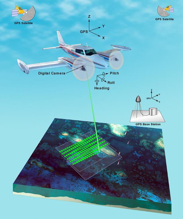
Illustration of airborne lidar acquisition platform
Airborne lidar is a surveying method that measures distance to a target from a survey plane by illuminating that target with a pulsed laser light, and measuring the reflected pulses with a sensor. Differences in laser return times and wavelengths can then be used to make digital 3D-representations of the target.
Airborne lidar is a surveying method that measures distance to a target from a survey plane by illuminating that target with a pulsed laser light, and measuring the reflected pulses with a sensor. Differences in laser return times and wavelengths can then be used to make digital 3D-representations of the target.

Lidar plane
Airborne lidar is a surveying method that measures distance to a target from a survey plane by illuminating that target with a pulsed laser light, and measuring the reflected pulses with a sensor. Differences in laser return times and wavelengths can then be used to make digital 3D-representations of the target.
Airborne lidar is a surveying method that measures distance to a target from a survey plane by illuminating that target with a pulsed laser light, and measuring the reflected pulses with a sensor. Differences in laser return times and wavelengths can then be used to make digital 3D-representations of the target.

Map of study areas in Sonoma and Mendocino Counties.
Map of study areas and key geographic features in Sonoma and Mendocino Counties.
Map of study areas and key geographic features in Sonoma and Mendocino Counties.

Moon Over Bosque Del Apache National Wildlife Refuge
Scenic view of the moon over Bosque Del Apache National Wildlife Refuge.
Scenic view of the moon over Bosque Del Apache National Wildlife Refuge.

Northeast crater wall above Sugar Bowl, Mount St. Helens with annot...
Northeast crater wall above Sugar Bowl, Mount St. Helens with annotated deposits from some of the Spirit Lake Stage eruptive periods. Photograph from late summer 2003.
Northeast crater wall above Sugar Bowl, Mount St. Helens with annotated deposits from some of the Spirit Lake Stage eruptive periods. Photograph from late summer 2003.

Northern Pintail (Anas acuta)
Northern Pintail walking on the ground.
Northern Pintail walking on the ground.

Outstanding In the Field
Video narrated by Amy Macleod, USGS Wildlife Biologist Research Assistant at the West Glacier Field Station in Montana, on the making of the scent lures for the Northern Divide Bear Project. Scent lures are concoctions made from decomposing fish and cows blood. The scent lure is wretchedly stinky and making it is one of the dirtiest jobs in the USGS.
By

Potential Pathways for Veterinary Medicines in Soil and Water
Potential pathways for veterinary medicines in soil and water
Potential pathways for veterinary medicines in soil and water
Propagation of Seismic Waves in Atwood Building, Top View
Animation of the recorded displacements of Atwood Building, Anchorage, Alaska during the M=3.7 Point MacKenzie, Alaska earthquake of 15 Dec. 2003. Displacements are color coded in order to see the propagation of seismic waves in the building during the earthquake. View from top.
Animation of the recorded displacements of Atwood Building, Anchorage, Alaska during the M=3.7 Point MacKenzie, Alaska earthquake of 15 Dec. 2003. Displacements are color coded in order to see the propagation of seismic waves in the building during the earthquake. View from top.
Propagation of Seismic Waves, Atwood Building, Oblique View
Animation of the recorded displacements of Atwood Building, Anchorage, Alaska during the M=3.7 Point MacKenzie, Alaska earthquake of 15 Dec. 2003. Displacements are color coded in order to see the propagation of seismic waves in the building during the earthquake. Oblique view.
Animation of the recorded displacements of Atwood Building, Anchorage, Alaska during the M=3.7 Point MacKenzie, Alaska earthquake of 15 Dec. 2003. Displacements are color coded in order to see the propagation of seismic waves in the building during the earthquake. Oblique view.

Resurrection Bay multibeam imagery
Sonar-generated image showing underwater topography and the potential for landslides near the head of Resurrection Bay, Alaska. The terrain looks three times as steep as it occurs naturally. The arrow points to underwater landslide debris from the collapse of a fan-delta following the great Alaskan earthquake of 1964.
Sonar-generated image showing underwater topography and the potential for landslides near the head of Resurrection Bay, Alaska. The terrain looks three times as steep as it occurs naturally. The arrow points to underwater landslide debris from the collapse of a fan-delta following the great Alaskan earthquake of 1964.

Sandhill Crane (Grus canadensis)
Sandhill crane grazing in a grass field.
Sandhill crane grazing in a grass field.

Sandhill Crane (Grus canadensis)
Sandhill crane standing on the ground.
Sandhill crane standing on the ground.

Sandhill Crane (Grus canadensis)
Sandhill crane standing on the ground.
Sandhill crane standing on the ground.

Sandhill Cranes (Grus canadensis)
Two sandhill cranes walking along the ground.
Two sandhill cranes walking along the ground.

Sandhill Cranes and Sunrise
Sandhill Cranes walking in the water.
Sandhill Cranes walking in the water.