
Ash covered snow is a result of wind direction, resulting in left portion of cone free of ash while the right portion is covered. Snowstorms later covered these ash layers, which in turn were covered by new ash. The result was many alternating layers of snow and ash.
All Multimedia
Access all multimedia to include images, video, audio, webcams, before-after imagery, and more. Filter and explore with filtering options to refine search.
Filter Total Items: 26025

Ash-covered summit of Mount St. Helens. Aerial view looking north-N...
Ash covered snow is a result of wind direction, resulting in left portion of cone free of ash while the right portion is covered. Snowstorms later covered these ash layers, which in turn were covered by new ash. The result was many alternating layers of snow and ash.

Phreatic eruption on Mount St. Helens pre-May 18, 1981
View from the northwest of a phreatic eruption on Mount St. Helens pre- May 18, 1980 eruption.
View from the northwest of a phreatic eruption on Mount St. Helens pre- May 18, 1980 eruption.

View looking west of Mount St. Helens' summit after several small e...
View looking west of Mount St. Helens' summit after several small explosive eruptions. The smaller of the two pit craters was formed first on March 27. Subsequent eruptions opened the farther crater.
View looking west of Mount St. Helens' summit after several small explosive eruptions. The smaller of the two pit craters was formed first on March 27. Subsequent eruptions opened the farther crater.

Crater in Mount St. Helens summit and ash (swath of dark) distribut...
An east-west fault across middle of summit area and an uplift or bulge on upper north flank of the volcano are also visible in this photo.
An east-west fault across middle of summit area and an uplift or bulge on upper north flank of the volcano are also visible in this photo.

View from the north of Mount St. Helens' eruption and first crater.
View from the north of Mount St. Helens' eruption and first crater.
View from the north of Mount St. Helens' eruption and first crater.

Upper cone of Mount St. Helens before the May 18, 1980 eruption; no...
Although seismic activity began under Mount St. Helens on March 20, this overflight showed no unusual features except numerous tracks of earthquake-triggered snow avalanches. No evidence of fracturing of summit area was detected during careful visual observations on the afternoon of March 24, 1980.
Although seismic activity began under Mount St. Helens on March 20, this overflight showed no unusual features except numerous tracks of earthquake-triggered snow avalanches. No evidence of fracturing of summit area was detected during careful visual observations on the afternoon of March 24, 1980.

Mount St. Helens before May 18, 1980 eruption
Before the devastating May 18, 1980 eruption, Mount St. Helens was considered to be one of the most beautiful and most frequently-climbed peaks in the Cascade Range. Spirit Lake was a vacation area offering hiking, camping, boating, and fishing.
Before the devastating May 18, 1980 eruption, Mount St. Helens was considered to be one of the most beautiful and most frequently-climbed peaks in the Cascade Range. Spirit Lake was a vacation area offering hiking, camping, boating, and fishing.

USGS Deputy Director Joe Cragwall with Susan Russell-Robinson
Susan Russell-Robinson with USGS Deputy Director Joe Cragwall at a National Archives exhibit marking the 100th anniversary of the USGS in 1979.
Susan Russell-Robinson with USGS Deputy Director Joe Cragwall at a National Archives exhibit marking the 100th anniversary of the USGS in 1979.

Aerial photo of Mount St. Helens volcano, pre-1980 eruption
Before the eruption of May 18, 1980, Mount St. Helens' elevation was 2,950 m (9,677 ft). View from the west, Mount Adams in distance. S. Fork Toutle River is valley in center of photo.
Mount Adams elevation is 3,745 m (12, 286 ft). Mount St. Helens was the smallest of five major volcanic peaks in Washington State.

Goat Rocks age eruptive deposits (Mount St. Helens), Floating Islan...
Studebaker Ridge formed during the Tertiary geologic time period (65 million to 2.6 million years ago). The pyroclastic surge from the May 18, 1980 eruption destroyed the trees on the ridge.
Studebaker Ridge formed during the Tertiary geologic time period (65 million to 2.6 million years ago). The pyroclastic surge from the May 18, 1980 eruption destroyed the trees on the ridge.

Summit region (Kalama age–1479 to 1720 C.E.) of Mount St. Helens lo...
Summit region (Kalama age–1479 to 1720 C.E.) of Mount St. Helens looking northeast. Spirit Lake and Mount Adams in background. September 28, 1979.
Summit region (Kalama age–1479 to 1720 C.E.) of Mount St. Helens looking northeast. Spirit Lake and Mount Adams in background. September 28, 1979.

Worm Complex on the SE flank of Mount St. Helens—Middle Kalama lava...
Worm Complex on the southeast flank of Mount St. Helens—Middle Kalama lava flows in center of image. Photo from September 28, 1979. Click to view larger image.
Worm Complex on the southeast flank of Mount St. Helens—Middle Kalama lava flows in center of image. Photo from September 28, 1979. Click to view larger image.

USGS Centennial March
This is the official USGS Centennial March which was composed and recorded to celebrate the USGS's first 100 years which occurred in 1979. The piece was composed and arranged by David Ward, a staff arranger with the US Navy Band in the 1970s. It was recorded on September 25, 1978 and conducted by CDR Ned Muffley.
This is the official USGS Centennial March which was composed and recorded to celebrate the USGS's first 100 years which occurred in 1979. The piece was composed and arranged by David Ward, a staff arranger with the US Navy Band in the 1970s. It was recorded on September 25, 1978 and conducted by CDR Ned Muffley.

San Gorgonio Pass landscape: land of geologic complexity
Photograph from summit of San Jacinto Peak looking north across San Gorgonio Pass toward San Gorgonio Mountain. San Gorgonio River and Interstate Highway 10 traverse the Pass lowland; the Whitewater River drains the San Bernardino Mountains and flows eastward into the Salton Trough.
Photograph from summit of San Jacinto Peak looking north across San Gorgonio Pass toward San Gorgonio Mountain. San Gorgonio River and Interstate Highway 10 traverse the Pass lowland; the Whitewater River drains the San Bernardino Mountains and flows eastward into the Salton Trough.

Aerial photograph of Pāhala region, Island of Hawai'i—Dec. 11, 1976
(Left) Aerial photograph of the Pāhala area, on the southern side of the Island of Hawaiʻi, taken on December 11, 1976. (Right) The backside of the same photo showing labeled field locations, marked with a pinhole through the photograph, which correspond to the geologist’s field notes.
(Left) Aerial photograph of the Pāhala area, on the southern side of the Island of Hawaiʻi, taken on December 11, 1976. (Right) The backside of the same photo showing labeled field locations, marked with a pinhole through the photograph, which correspond to the geologist’s field notes.
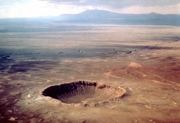
Aerial view of Meteor Crater, color, Coconino County, Arizona
Meteor Crater formed approximately 50,000 years ago by the impact of a 100,000-ton iron-nickel meteorite, ~30 m in diameter, which struck at an approximate speed of 12-20 km/sec.
Meteor Crater formed approximately 50,000 years ago by the impact of a 100,000-ton iron-nickel meteorite, ~30 m in diameter, which struck at an approximate speed of 12-20 km/sec.

Morning Glory Pool before and after garbage clean out, Yellowstone.
Morning Glory Pool used to be clear blue in color, as shown in the historic undated photo on the left (National Park Service photo by Rentchler).
Morning Glory Pool used to be clear blue in color, as shown in the historic undated photo on the left (National Park Service photo by Rentchler).

Mount Konocti on the western shore of Clear Lake, California
Mount Konocti, a mostly dacitic composite cone, on the western shore of Clear Lake, California. Thurston Lake is in the foreground.
Mount Konocti, a mostly dacitic composite cone, on the western shore of Clear Lake, California. Thurston Lake is in the foreground.

Submerged coconut grove at Halapē after 1975 quake, Kīlauea
A M 7.7 earthquake on November 29, 1975, was located beneath the south flank of Kīlauea.
A M 7.7 earthquake on November 29, 1975, was located beneath the south flank of Kīlauea.

1975 earthquake in HVNP
At 04:48 HST that morning, a magnitude-7.7 earthquake shook the island and generated a local tsunami that killed 2 people. Strong shaking from the earthquake produced damage at many locations on the Island of Hawai‘i. Within Hawai‘i Volcanoes National Park, sections of Crater Rim Drive (shown in this photo) cracked, some slumped toward the crater.
At 04:48 HST that morning, a magnitude-7.7 earthquake shook the island and generated a local tsunami that killed 2 people. Strong shaking from the earthquake produced damage at many locations on the Island of Hawai‘i. Within Hawai‘i Volcanoes National Park, sections of Crater Rim Drive (shown in this photo) cracked, some slumped toward the crater.

Earthquake-damaged road, Hawai‘i Volcanoes National Park, Kīlauea
Ground cracks along Crater Rim Drive in Hawai‘i Volcanoes National Park caused by the M 7.7 earthquake on November 25, 1975. The cracks resulted from slumping of the ground toward the rim of Kīlauea Crater, the edge of which is left of the guardrails.
Ground cracks along Crater Rim Drive in Hawai‘i Volcanoes National Park caused by the M 7.7 earthquake on November 25, 1975. The cracks resulted from slumping of the ground toward the rim of Kīlauea Crater, the edge of which is left of the guardrails.