
Studebaker Ridge formed during the Tertiary geologic time period (65 million to 2.6 million years ago). The pyroclastic surge from the May 18, 1980 eruption destroyed the trees on the ridge.
Images
Explore our planet through photography and imagery, including climate change and water all the way back to the 1800s when the USGS was surveying the country by horse and buggy.
Filter Total Items: 21557

Goat Rocks age eruptive deposits (Mount St. Helens), Floating Islan...
Studebaker Ridge formed during the Tertiary geologic time period (65 million to 2.6 million years ago). The pyroclastic surge from the May 18, 1980 eruption destroyed the trees on the ridge.

Summit region (Kalama age–1479 to 1720 C.E.) of Mount St. Helens lo...
Summit region (Kalama age–1479 to 1720 C.E.) of Mount St. Helens looking northeast. Spirit Lake and Mount Adams in background. September 28, 1979.
Summit region (Kalama age–1479 to 1720 C.E.) of Mount St. Helens looking northeast. Spirit Lake and Mount Adams in background. September 28, 1979.

Worm Complex on the SE flank of Mount St. Helens—Middle Kalama lava...
Worm Complex on the southeast flank of Mount St. Helens—Middle Kalama lava flows in center of image. Photo from September 28, 1979. Click to view larger image.
Worm Complex on the southeast flank of Mount St. Helens—Middle Kalama lava flows in center of image. Photo from September 28, 1979. Click to view larger image.

San Gorgonio Pass landscape: land of geologic complexity
Photograph from summit of San Jacinto Peak looking north across San Gorgonio Pass toward San Gorgonio Mountain. San Gorgonio River and Interstate Highway 10 traverse the Pass lowland; the Whitewater River drains the San Bernardino Mountains and flows eastward into the Salton Trough.
Photograph from summit of San Jacinto Peak looking north across San Gorgonio Pass toward San Gorgonio Mountain. San Gorgonio River and Interstate Highway 10 traverse the Pass lowland; the Whitewater River drains the San Bernardino Mountains and flows eastward into the Salton Trough.

Aerial photograph of Pāhala region, Island of Hawai'i—Dec. 11, 1976
(Left) Aerial photograph of the Pāhala area, on the southern side of the Island of Hawaiʻi, taken on December 11, 1976. (Right) The backside of the same photo showing labeled field locations, marked with a pinhole through the photograph, which correspond to the geologist’s field notes.
(Left) Aerial photograph of the Pāhala area, on the southern side of the Island of Hawaiʻi, taken on December 11, 1976. (Right) The backside of the same photo showing labeled field locations, marked with a pinhole through the photograph, which correspond to the geologist’s field notes.
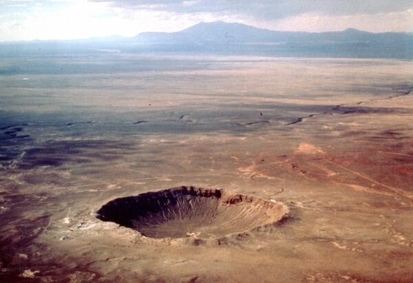
Aerial view of Meteor Crater, color, Coconino County, Arizona
Meteor Crater formed approximately 50,000 years ago by the impact of a 100,000-ton iron-nickel meteorite, ~30 m in diameter, which struck at an approximate speed of 12-20 km/sec.
Meteor Crater formed approximately 50,000 years ago by the impact of a 100,000-ton iron-nickel meteorite, ~30 m in diameter, which struck at an approximate speed of 12-20 km/sec.

Morning Glory Pool before and after garbage clean out, Yellowstone.
Morning Glory Pool used to be clear blue in color, as shown in the historic undated photo on the left (National Park Service photo by Rentchler).
Morning Glory Pool used to be clear blue in color, as shown in the historic undated photo on the left (National Park Service photo by Rentchler).

Mount Konocti on the western shore of Clear Lake, California
Mount Konocti, a mostly dacitic composite cone, on the western shore of Clear Lake, California. Thurston Lake is in the foreground.
Mount Konocti, a mostly dacitic composite cone, on the western shore of Clear Lake, California. Thurston Lake is in the foreground.

Submerged coconut grove at Halapē after 1975 quake, Kīlauea
A M 7.7 earthquake on November 29, 1975, was located beneath the south flank of Kīlauea.
A M 7.7 earthquake on November 29, 1975, was located beneath the south flank of Kīlauea.

1975 earthquake in HVNP
At 04:48 HST that morning, a magnitude-7.7 earthquake shook the island and generated a local tsunami that killed 2 people. Strong shaking from the earthquake produced damage at many locations on the Island of Hawai‘i. Within Hawai‘i Volcanoes National Park, sections of Crater Rim Drive (shown in this photo) cracked, some slumped toward the crater.
At 04:48 HST that morning, a magnitude-7.7 earthquake shook the island and generated a local tsunami that killed 2 people. Strong shaking from the earthquake produced damage at many locations on the Island of Hawai‘i. Within Hawai‘i Volcanoes National Park, sections of Crater Rim Drive (shown in this photo) cracked, some slumped toward the crater.

Earthquake-damaged road, Hawai‘i Volcanoes National Park, Kīlauea
Ground cracks along Crater Rim Drive in Hawai‘i Volcanoes National Park caused by the M 7.7 earthquake on November 25, 1975. The cracks resulted from slumping of the ground toward the rim of Kīlauea Crater, the edge of which is left of the guardrails.
Ground cracks along Crater Rim Drive in Hawai‘i Volcanoes National Park caused by the M 7.7 earthquake on November 25, 1975. The cracks resulted from slumping of the ground toward the rim of Kīlauea Crater, the edge of which is left of the guardrails.

Landsat 1 image showing the Fallon, Nevada area
Example of the Landsat 1-5 MSS Collection 2 level-1 product. This Landsat 1 image was acquired on June 26, 1974 near Fallon, Nevada and is shown as a false color composite using the near-infrared, red, and green bands (bands 3,2,1).
Example of the Landsat 1-5 MSS Collection 2 level-1 product. This Landsat 1 image was acquired on June 26, 1974 near Fallon, Nevada and is shown as a false color composite using the near-infrared, red, and green bands (bands 3,2,1).

USGS Topographers at Work
Warren "Buz" Brown making second-order measurements using a Kern theodolite. The blind is to prevent temperature variations from affecting the instrument.
Warren "Buz" Brown making second-order measurements using a Kern theodolite. The blind is to prevent temperature variations from affecting the instrument.

USGS station 08116650 Brazos River near Rosharon, Texas
U.S. Geological Survey streamflow-gaging station 08116650 Brazos River near Rosharon, Texas, looking upstream from Farm-to-Market Road (FM) 1462 bridge, August 28, 1973.
USGS SIR 2009–5174
U.S. Geological Survey streamflow-gaging station 08116650 Brazos River near Rosharon, Texas, looking upstream from Farm-to-Market Road (FM) 1462 bridge, August 28, 1973.
USGS SIR 2009–5174

Generalized geologic map of the Eocene Absaroka volcanic field
Generalized geologic map of the Eocene Absaroka volcanic field (modified from Smedes and Prostka, 1972 and “Geology of Wyoming”).
Generalized geologic map of the Eocene Absaroka volcanic field (modified from Smedes and Prostka, 1972 and “Geology of Wyoming”).

Harrison 'Jack' Schmitt with the American Flag and Earth (Apollo 17)
Harrison H. Schmitt during the Apollo 17 mission.
Harrison H. Schmitt during the Apollo 17 mission.

False-colored-composite satellite image, Great Salt Lake, Sept 1972
This is a false-colored-composite satellite image of Great Salt Lake, Sept 1972. The vegetation appears red.
This is a false-colored-composite satellite image of Great Salt Lake, Sept 1972. The vegetation appears red.

Kīlauea's 1971 Southwest Rift Zone Eruption: A First in 52 Years
As erupting fissures migrated down Kīlauea's southwest rift zone in September 1971 for the first time in 52 years, many spectators hiked into the Ka‘ū Desert for a closer view of the rare event. Hawai‘i Volcanoes National Park rangers patrolled the area on horseback to keep people a safe distance from the lava fountains. Photo courtesy of NPS.
As erupting fissures migrated down Kīlauea's southwest rift zone in September 1971 for the first time in 52 years, many spectators hiked into the Ka‘ū Desert for a closer view of the rare event. Hawai‘i Volcanoes National Park rangers patrolled the area on horseback to keep people a safe distance from the lava fountains. Photo courtesy of NPS.

NASA Image AS15-92-12424
NASA image AS15-92-12424: Dave Scott’s photograph of Jim Irwin digging a trench to sample the lunar regolith during the second EVA of Apollo 15. The trench was dug down to the level at which it became much harder to remove.
NASA image AS15-92-12424: Dave Scott’s photograph of Jim Irwin digging a trench to sample the lunar regolith during the second EVA of Apollo 15. The trench was dug down to the level at which it became much harder to remove.

NASA Image AS15-92-12439
NASA Image AS15-92-12439: Dave Scott’s photographic documentation of the trench dug. Note the way the fine rock powder clumps together and can hold a vertical face.
NASA Image AS15-92-12439: Dave Scott’s photographic documentation of the trench dug. Note the way the fine rock powder clumps together and can hold a vertical face.