
Grand Prismatic Spring in Midway Geyser Basin Yellowstone National Park on October 19, 2017.
Images
Explore our planet through photography and imagery, including climate change and water all the way back to the 1800s when the USGS was surveying the country by horse and buggy.
Filter Total Items: 21558

Grand Prismatic Spring in Midway Geyser Basin Yellowstone
Grand Prismatic Spring in Midway Geyser Basin Yellowstone National Park on October 19, 2017.

Rich Kim builds a giant gartersnake trap
Rich Kim works on giant gartersnake trap building.
Rich Kim works on giant gartersnake trap building.

Sunset lake in Black Sand Basin of Yellowstone National Park
Sunset lake in Black Sand Basin of Yellowstone National Park
Sunset lake in Black Sand Basin of Yellowstone National Park

USGS hydrographer makes a flood measurement in Tusten, NY
USGS hydrographer Dave Thompson makes a near-peak flood measurement off a bridge at Tenmile River in Tusten, New York.
USGS hydrographer Dave Thompson makes a near-peak flood measurement off a bridge at Tenmile River in Tusten, New York.

HVO staff work together while maintaining social distancing as they install diff
HVO staff work together while maintaining social distancing as they install different parts of the new Mauna Loa summit MultiGAS station on April 27. In the left side of the image, an HVO field engineer connects solar panels to the batteries that will power the MultiGAS station.
HVO staff work together while maintaining social distancing as they install different parts of the new Mauna Loa summit MultiGAS station on April 27. In the left side of the image, an HVO field engineer connects solar panels to the batteries that will power the MultiGAS station.

North Platte River ADCP Measurement
Recent warm weather has increased flow in the North Platte River to above average for the date at the streamgage at Northgate, CO (just upstream of the WY-CO stateline). Real-time data online at: http://ow.ly/vodL50zt6YO
Recent warm weather has increased flow in the North Platte River to above average for the date at the streamgage at Northgate, CO (just upstream of the WY-CO stateline). Real-time data online at: http://ow.ly/vodL50zt6YO

Meagan Gonneea at the Herring River Estuary, Wellfleet, MA
When wetland plants in the northeast emerged this spring, USGS scientists were working from home and unable to start many planned research activities. However, many instruments were already deployed and continued to collect information critical to USGS research.
When wetland plants in the northeast emerged this spring, USGS scientists were working from home and unable to start many planned research activities. However, many instruments were already deployed and continued to collect information critical to USGS research.

Hydrothermal isotopes from Yellowstone and Iceland
The relationship between Δ30 and N2/3He ratios in hydrothermal gases from Iceland and Yellowstone. Δ30 and N2/3He ratios are shown for samples collected from gases in Iceland (yellow circles) and Yellowstone (red circles). The Yellowstone mantle-endmember is arguably indistinguishable in terms of N2/3He from the convecting upper mantle (grey diamonds).
The relationship between Δ30 and N2/3He ratios in hydrothermal gases from Iceland and Yellowstone. Δ30 and N2/3He ratios are shown for samples collected from gases in Iceland (yellow circles) and Yellowstone (red circles). The Yellowstone mantle-endmember is arguably indistinguishable in terms of N2/3He from the convecting upper mantle (grey diamonds).

Releasing red-legged frog tadpoles into a temporary enclosure
Researchers Liz Gallegos and Adam Backlin releasing California red-legged frog tadpoles into a temporary enclosure as part of an international translocation. The tadpoles were collected from the Sierra San Pedro Martir mountains of Baja California, Mexico and transported to two sites in the United States.
Researchers Liz Gallegos and Adam Backlin releasing California red-legged frog tadpoles into a temporary enclosure as part of an international translocation. The tadpoles were collected from the Sierra San Pedro Martir mountains of Baja California, Mexico and transported to two sites in the United States.

Translocating a red-legged frog egg mass
Adam Backlin and Elizabeth Gallegos translocatw an egg mass of the California Red Legged Frog from a donor site in the mountains of Baja California MX. The recipient site, where the photo was taken, was at Mesa Grande in San Diego County.
Adam Backlin and Elizabeth Gallegos translocatw an egg mass of the California Red Legged Frog from a donor site in the mountains of Baja California MX. The recipient site, where the photo was taken, was at Mesa Grande in San Diego County.

USGS stream gage 14314500 Clearwater River above Trap Creek, OR

Mauna Loa summit mission-critical fieldwork: MultiGAS installation
On April 27, HVO field engineers and a gas geochemist conducted fieldwork to increase HVO's volcano-monitoring capabilities. Staff installed a MultiGAS station to collect volcanic gas data from within Moku‘āweoweo, Mauna Loa's summit caldera. The work was carried out with permission of Hawai‘i Volcanoes National Park.
On April 27, HVO field engineers and a gas geochemist conducted fieldwork to increase HVO's volcano-monitoring capabilities. Staff installed a MultiGAS station to collect volcanic gas data from within Moku‘āweoweo, Mauna Loa's summit caldera. The work was carried out with permission of Hawai‘i Volcanoes National Park.

Eastern newt (Notophthalmus viridescens) in Wisconsin
Eastern newt (Notophthalmus viridescens) in Wisconsin.
Eastern newt (Notophthalmus viridescens) in Wisconsin.

Geologic Map of the Southern Flank of Mauna Loa Volcano, Island of Hawai‘i
Geologic Map of the Southern Flank of Mauna Loa Volcano, Island of Hawai‘i
Geologic Map of the Southern Flank of Mauna Loa Volcano, Island of Hawai‘i

USGS scientists visit Weather Station in Glacier National Park
USGS scientists visit Garden Wall Weather Station in Glacier National Park. This high elevation weather station, just below the Continental Divide near Logan Pass, collects weather data that is used each spring to forecast avalanche hazard for the road crew plowing Going to the Sun Road. The data is also used by USGS avalanche scientists to study the con
USGS scientists visit Garden Wall Weather Station in Glacier National Park. This high elevation weather station, just below the Continental Divide near Logan Pass, collects weather data that is used each spring to forecast avalanche hazard for the road crew plowing Going to the Sun Road. The data is also used by USGS avalanche scientists to study the con

The relationship between Δ30 and N2/3He ratios in hydrothermal gases from
The relationship between Δ30 and N2/3He ratios in hydrothermal gases from Iceland and Yellowstone. Δ30 and N2/3He ratios are shown for samples collected from gases in Iceland (yellow circles) and Yellowstone (red circles). The Yellowstone mantle-endmember is arguably indistinguishable in terms of N2/3He from the convecting upper mantle (grey diamonds).
The relationship between Δ30 and N2/3He ratios in hydrothermal gases from Iceland and Yellowstone. Δ30 and N2/3He ratios are shown for samples collected from gases in Iceland (yellow circles) and Yellowstone (red circles). The Yellowstone mantle-endmember is arguably indistinguishable in terms of N2/3He from the convecting upper mantle (grey diamonds).

Kevin Kirlin making an ADCP measurement off a cableway at stream gage
Kevin Kirlin making an ADCP (streampro) measurement off a cableway at stream gage 12411000 North Fork Coeur D' Alene River above Shoshone Creek near Prichard, ID.
Kevin Kirlin making an ADCP (streampro) measurement off a cableway at stream gage 12411000 North Fork Coeur D' Alene River above Shoshone Creek near Prichard, ID.

First Open Water Measurement of the Year
With ice off the Wind River near Kinnear, we headed out to make a streamflow measurement in open water. Flows were a bit higher than average for the date (35 years of record) and can be found real-time at: http://ow.ly/eSXS50zcGLF
With ice off the Wind River near Kinnear, we headed out to make a streamflow measurement in open water. Flows were a bit higher than average for the date (35 years of record) and can be found real-time at: http://ow.ly/eSXS50zcGLF

Here's looking at you
Scientists with the Interagency Grizzly Bear Study Team have seen the first female grizzly bear with cubs of the year for 2020 in Yellowstone National Park. The radio-collared female was seen with 3 cubs during a telemetry tracking flight on 4/10. One of the 3 cubs is hard to see between the 2 obvious siblings, but you can just make out its
Scientists with the Interagency Grizzly Bear Study Team have seen the first female grizzly bear with cubs of the year for 2020 in Yellowstone National Park. The radio-collared female was seen with 3 cubs during a telemetry tracking flight on 4/10. One of the 3 cubs is hard to see between the 2 obvious siblings, but you can just make out its
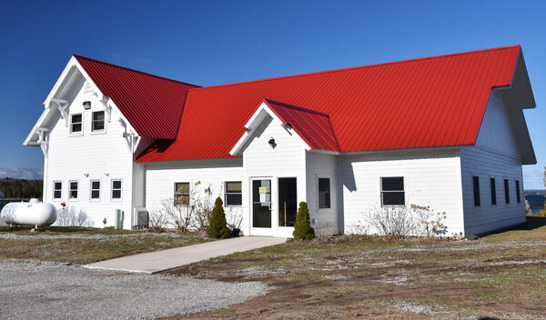
The Hammond Bay Biological Station Administration Building
The USGS Hammond Bay Biological Station, a field station of the Great Lakes Science Center, located near Millersburg, Michigan.
The USGS Hammond Bay Biological Station, a field station of the Great Lakes Science Center, located near Millersburg, Michigan.

USGS Responds to Spring Flooding in Minnesota
On April 10, USGS hydrographer Josh Sundberg measures Red River water flowing over the road in East Grand Forks, Minnesota as flood protection walls prevent further flooding.
On April 10, USGS hydrographer Josh Sundberg measures Red River water flowing over the road in East Grand Forks, Minnesota as flood protection walls prevent further flooding.