
An HVO scientist tests a colorimeter instrument on the water lake within Halema‘uma‘u, at Kīlauea's summit. Colorimetry is the measurement of the wavelength and intensity of light. USGS photo by M. Patrick.
Images
Explore our planet through photography and imagery, including climate change and water all the way back to the 1800s when the USGS was surveying the country by horse and buggy.
Filter Total Items: 21558

HVO scientist tests colorimeter instrument at Kīlauea's summit
An HVO scientist tests a colorimeter instrument on the water lake within Halema‘uma‘u, at Kīlauea's summit. Colorimetry is the measurement of the wavelength and intensity of light. USGS photo by M. Patrick.

Winter Streamflow Measurement
Stream stage is still accurately measured by equip under ice, and fluctuates a fair amount due to ice damming and accumulation. Streamflow, however, during most of the winter is typically quite stable.
Stream stage is still accurately measured by equip under ice, and fluctuates a fair amount due to ice damming and accumulation. Streamflow, however, during most of the winter is typically quite stable.

A pack string crossing the Yellowstone River in the remote Thorofare region
A pack string crossing the Yellowstone River in the remote Thorofare region. National Park Service photo courtesy of Sherrie and Ron White, August 21, 2016.
A pack string crossing the Yellowstone River in the remote Thorofare region. National Park Service photo courtesy of Sherrie and Ron White, August 21, 2016.

Landsat 8 image of Phoenix, Arizona
Landsat 8 image of Phoenix, Arizona, acquired on January 13, 2020 (Path 37 Row 36). This false color image uses the short-wave infrared, near infrared, and red bands (bands 6, 5, 4) to display the data.
For more information about Landsat, please visit www.usgs.gov/Landsat
Landsat 8 image of Phoenix, Arizona, acquired on January 13, 2020 (Path 37 Row 36). This false color image uses the short-wave infrared, near infrared, and red bands (bands 6, 5, 4) to display the data.
For more information about Landsat, please visit www.usgs.gov/Landsat

Installing a temporary seismometer
Photo (L-R) Jose Cancel of Puerto Rico Seismic Network (PRSN), Alena Leeds of USGS and Javier Santiago of PRSN install a temporary seismometer at Sabana Yeguas in southwestern Puerto Rico on Jan. 10, 2020.
Photo (L-R) Jose Cancel of Puerto Rico Seismic Network (PRSN), Alena Leeds of USGS and Javier Santiago of PRSN install a temporary seismometer at Sabana Yeguas in southwestern Puerto Rico on Jan. 10, 2020.

Imperial Geyser looking south, Yellowstone
Imperial Geyser hot spring pool in Yellowstone National Park is about 30 m (about 100 ft) across and contains alkaline-Cl waters with a steam vent in the pool and mudpots outside the pool area (in the upper right part of this photo). USGS Photo by Pat Shanks, 2019.
Imperial Geyser hot spring pool in Yellowstone National Park is about 30 m (about 100 ft) across and contains alkaline-Cl waters with a steam vent in the pool and mudpots outside the pool area (in the upper right part of this photo). USGS Photo by Pat Shanks, 2019.

Large microscope used for counting microplastics found in water sample
Large microscope used for counting microplastics found in water samples
Large microscope used for counting microplastics found in water samples
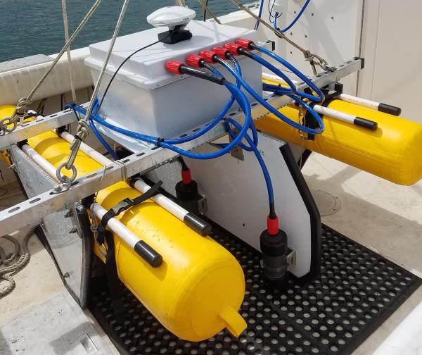
SQUID-5 - Structure-from-Motion Quantitative Underwater Imaging Device
The SQUID-5, or a Structure-from-Motion (SfM) Quantitative Underwater Imaging Device with 5 cameras is a towed surface vehicle with an onboard Global Navigation Satellite System (GNSS) and 5 downward-looking cameras with overlapping views of the seafloor.
The SQUID-5, or a Structure-from-Motion (SfM) Quantitative Underwater Imaging Device with 5 cameras is a towed surface vehicle with an onboard Global Navigation Satellite System (GNSS) and 5 downward-looking cameras with overlapping views of the seafloor.

Visitors in the busy Old Faithful area
Visitors in the busy Old Faithful area. National Park Service photo by Neal Herbert, May 27, 2017.
Visitors in the busy Old Faithful area. National Park Service photo by Neal Herbert, May 27, 2017.

Measuring streamflow through ice
Hydrologic technician Ryan Moore measures streamflow through ice at USGS streamgage station 13131000, Antelope Creek near Darlington, Idaho.
Hydrologic technician Ryan Moore measures streamflow through ice at USGS streamgage station 13131000, Antelope Creek near Darlington, Idaho.

Mountain Sunset over Susquehanna River, Pennsylvania
Mountain Sunset over Susquehanna River, Pennsylvania
Mountain Sunset over Susquehanna River, Pennsylvania

Reported lionfish sightings from 1985 - January 8, 2020
Reported lionfish sightings from 1985 - January 8, 2020
Data Source: U.S. Geological Survey, Nonindigenous Aquatic Species Database
Reported lionfish sightings from 1985 - January 8, 2020
Data Source: U.S. Geological Survey, Nonindigenous Aquatic Species Database

Snowmobile Training Line-up
Lining up to finish our Snowmobile Safety Training class. Many of the roads we drive trucks on in the summer are inaccessible in the winter, so we must load up a machine.
Lining up to finish our Snowmobile Safety Training class. Many of the roads we drive trucks on in the summer are inaccessible in the winter, so we must load up a machine.

Western sandpiper in San Francisco Bay
A Western sandpiper in San Francisco Bay.
A Western sandpiper in San Francisco Bay.

A wave breaks over a degraded reef crest at Buck Island in St. Croix
A wave breaking over a degraded reef crest at Buck Island National Monument in St. Croix. Wave-breaking in these habitats relies on reef framework built by the elkhorn coral, Acropora palmata, which is now a threatened species throughout the western Atlantic.
A wave breaking over a degraded reef crest at Buck Island National Monument in St. Croix. Wave-breaking in these habitats relies on reef framework built by the elkhorn coral, Acropora palmata, which is now a threatened species throughout the western Atlantic.

Drone Pilots on a mission at Nelson Island Creek, Rowley, MA
In collaboration with the Marine Biological Laboratory (MBL) in Woods Hole, Massachusetts, the AIM group conducted UAS aerial surveys looking at vegetation classification/index surrounding a MBL gas flux tower located in Nelson Island Creek, Rowley, Massachusetts.
In collaboration with the Marine Biological Laboratory (MBL) in Woods Hole, Massachusetts, the AIM group conducted UAS aerial surveys looking at vegetation classification/index surrounding a MBL gas flux tower located in Nelson Island Creek, Rowley, Massachusetts.

Elizabeth Islands, Vineyard Sound, and Martha’s Vineyard.
This image created using the Continuous Bathymetry and Elevation Models of the Massachusetts Coastal Zone and Continental Shelf, shows the Elizabeth Islands, Vineyard Sound, and Martha’s Vineyard.
This image created using the Continuous Bathymetry and Elevation Models of the Massachusetts Coastal Zone and Continental Shelf, shows the Elizabeth Islands, Vineyard Sound, and Martha’s Vineyard.

Merrimack River, Plum Island, and Parker River Wildlife Refuge
This image created using the Continuous Bathymetry and Elevation Models of the Massachusetts Coastal Zone and Continental Shelf, shows the mouth of the Merrimack River, Plum Island and the Parker River National Wildlife Refuge.
This image created using the Continuous Bathymetry and Elevation Models of the Massachusetts Coastal Zone and Continental Shelf, shows the mouth of the Merrimack River, Plum Island and the Parker River National Wildlife Refuge.

Provincetown, MA
This image was created using the Continuous Bathymetry and Elevation Models of the Massachusetts Coastal Zone and Continental Shelf, shows Provincetown, MA and the northern section of the Cape Cod National Seashore.
This image was created using the Continuous Bathymetry and Elevation Models of the Massachusetts Coastal Zone and Continental Shelf, shows Provincetown, MA and the northern section of the Cape Cod National Seashore.

USGS St. Petersburg Studebaker Building
This historic brick Studebaker Building, originally built in 1925, was chosen as the location for the USGS St. Petersburg Coastal and Marine Science Center in the late 1980s.
This historic brick Studebaker Building, originally built in 1925, was chosen as the location for the USGS St. Petersburg Coastal and Marine Science Center in the late 1980s.

Map of roads in the Greater Yellowstone Ecosystem
Map of roads in the Greater Yellowstone Ecosystem. Source: Yellowstone Spatial Analysis Center.
Map of roads in the Greater Yellowstone Ecosystem. Source: Yellowstone Spatial Analysis Center.