
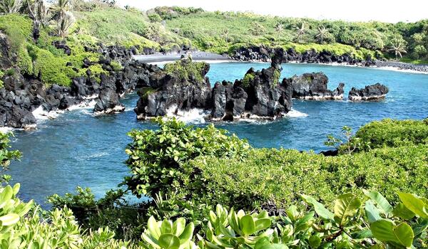
Lava islands, vegetated seaside cliffs, a black sand beach, and waves breaking against the steep ragged shoreline of a Hawaiian bay.
Images
Explore our planet through photography and imagery, including climate change and water all the way back to the 1800s when the USGS was surveying the country by horse and buggy.
Filter Total Items: 21558
Screwpine Tree (Pandanus sp.) and Beach Naupaka (Scaevola sericea)
Lava islands, vegetated seaside cliffs, a black sand beach, and waves breaking against the steep ragged shoreline of a Hawaiian bay.

Screwpine Tree (Pandanus sp.) and Beach Naupaka (Scaevola sericea)
Lava islands, vegetated seaside cliffs, a black sand beach, and waves breaking against the steep ragged shoreline of a Hawaiian bay.
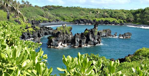
Lava islands, vegetated seaside cliffs, a black sand beach, and waves breaking against the steep ragged shoreline of a Hawaiian bay.
Screwpine Tree (Pandanus sp.) and Beach Naupaka (Scaevola sericea)
Lava islands, vegetated seaside cliffs, a black sand beach, and waves breaking against the steep ragged shoreline of a Hawaiian bay.
Lava islands, vegetated seaside cliffs, a black sand beach, and waves breaking against the steep ragged shoreline of a Hawaiian bay.
Screwpine Tree (Pandanus sp.) and Beach Naupaka (Scaevola sericea)
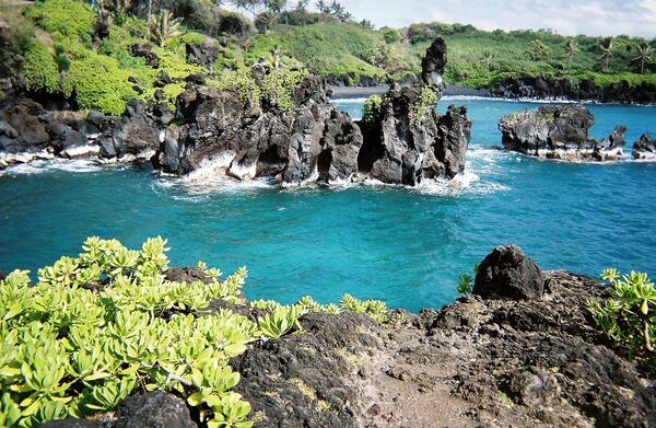
Lava islands, vegetated seaside cliffs, a black sand beach, and waves breaking against the steep ragged shoreline of a Hawaiian bay.
Lava islands, vegetated seaside cliffs, a black sand beach, and waves breaking against the steep ragged shoreline of a Hawaiian bay.

USGS boat on Hudson River
USGS scientist in a boat on the Hudson River
USGS scientist in a boat on the Hudson River

Tribal Training -- Seining for Fish
USGS Oklahoma Water Science Center Hydrologist Shana Mashburn and Tribal Environmental Technician seine for fish and insects during Tribal training class near Pauls Valley, Oklahoma.
USGS Oklahoma Water Science Center Hydrologist Shana Mashburn and Tribal Environmental Technician seine for fish and insects during Tribal training class near Pauls Valley, Oklahoma.

Tribal Training -- Water-Quality Sample Processing
USGS Oklahoma Water Science Center Hydrologists Monica Allen and Shana Mashburn demonstrate methods for processing water-quality samples at Tribal training class at Pauls Valley, Oklahoma.
USGS Oklahoma Water Science Center Hydrologists Monica Allen and Shana Mashburn demonstrate methods for processing water-quality samples at Tribal training class at Pauls Valley, Oklahoma.

Bar-tailed Godwit tagged Z0 near Naknek, Alaska
Bar-tailed Godwit tagged Z0 near Naknek, Alaska
Bar-tailed Godwit tagged Z0 near Naknek, Alaska

Bar-tailed Godwit with a satellite transmitter and tag Z0
Bar-tailed godwit "Z0" instrumented with an implanted Argos satellite transmitter (note dorsally exposed antenna) to facilitate aerodynamics during the species non-stop flights across the Pacific Ocean.
Bar-tailed godwit "Z0" instrumented with an implanted Argos satellite transmitter (note dorsally exposed antenna) to facilitate aerodynamics during the species non-stop flights across the Pacific Ocean.

Checking a fyke net in the Nome River
Biologists checking a fyke net as part of a fish project for the Norton Sound Economic Development Corporation. Otoliths were extracted and read for ages from the fish captured in this fyke net.
Biologists checking a fyke net as part of a fish project for the Norton Sound Economic Development Corporation. Otoliths were extracted and read for ages from the fish captured in this fyke net.

Fiber Optic Temperature Sensing in Hydrology
USGS hydrologists deploy fiber-optic distributed temperature sensing equipment in Ashumet Pond, Mashpee, Massachusetts. Fiber-optic distributed temperature sensing is an emerging technology that has promise for characterizing estuary-aquifer interaction. The technology evaluation was conducted by the USGS Office of Groundwater Branch of Geophysics in 2007.
USGS hydrologists deploy fiber-optic distributed temperature sensing equipment in Ashumet Pond, Mashpee, Massachusetts. Fiber-optic distributed temperature sensing is an emerging technology that has promise for characterizing estuary-aquifer interaction. The technology evaluation was conducted by the USGS Office of Groundwater Branch of Geophysics in 2007.

Juvenile salmon trapping on the Nome River, Alaska
Biologists checking a fyke net as part of a fish project for the Norton Sound Economic Development Corporation. Otoliths were extracted and read for ages from the fish captured in this fyke net.
Biologists checking a fyke net as part of a fish project for the Norton Sound Economic Development Corporation. Otoliths were extracted and read for ages from the fish captured in this fyke net.

Burrowing Owl
Birds found in and around the Salton Sea, California.
Birds found in and around the Salton Sea, California.

Burrowing Owl
Birds found in and around the Salton Sea, California.
Birds found in and around the Salton Sea, California.

Burrowing Owl
Birds found in and around the Salton Sea, California.
Birds found in and around the Salton Sea, California.

Caspian Tern
Birds found in and around the Salton Sea, California.
Birds found in and around the Salton Sea, California.

Caspian Tern Diving
Birds found in and around the Salton Sea, California.
Birds found in and around the Salton Sea, California.

Caspian Tern Diving
Birds found in and around the Salton Sea, California.
Birds found in and around the Salton Sea, California.

Caspian Tern Hovering
Birds found in and around the Salton Sea, California.
Birds found in and around the Salton Sea, California.

Elk River Development
Development along the mouth of the Elk River, a tributory of the Chesapeake Bay.
Development along the mouth of the Elk River, a tributory of the Chesapeake Bay.

Mud Volcano
A surface expression of geothermal activity.
A surface expression of geothermal activity.