
Photomicrograph depicting the siliceous frustulesof fifty species of diatoms arranged within a circular shape. Diatoms form the base of many marine and aquatic food chains and upon death, their glassy frustules form sediments known as diatomaceous earth.
Images
Explore our planet through photography and imagery, including climate change and water all the way back to the 1800s when the USGS was surveying the country by horse and buggy.
Filter Total Items: 21558

Diatoms (50 Species)
Photomicrograph depicting the siliceous frustulesof fifty species of diatoms arranged within a circular shape. Diatoms form the base of many marine and aquatic food chains and upon death, their glassy frustules form sediments known as diatomaceous earth.

Diatoms (50 Species)
A photomicrograph depicting the siliceous frustules of fifty species of diatoms arranged within a circular shape. The image has been inverted to white on black to bring out details. Diatoms form the base of many marine and aquatic foodchains and upon death, their glassy frustules form sediments known as diatomaceous earth.
A photomicrograph depicting the siliceous frustules of fifty species of diatoms arranged within a circular shape. The image has been inverted to white on black to bring out details. Diatoms form the base of many marine and aquatic foodchains and upon death, their glassy frustules form sediments known as diatomaceous earth.
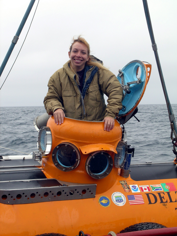
Dr. Christina Kellogg emerges from the submersible Delta
Dr. Christina Kellogg emerges from the submersible Delta after collecting coral samples in the Aleutian Islands in 2004.
Dr. Christina Kellogg emerges from the submersible Delta after collecting coral samples in the Aleutian Islands in 2004.

Foraminiferans (10 Species)
A photomicrograph depicting the calcium carbonate tests of ten species of marine foraminiferans. Upon death, their tests can form calcareous marine sediments known as foraminiferan ooze.
A photomicrograph depicting the calcium carbonate tests of ten species of marine foraminiferans. Upon death, their tests can form calcareous marine sediments known as foraminiferan ooze.

Foraminiferans (10 Species)
A photomicrograph depicting the calcium carbonate tests of ten species of marine foraminiferans. The image has been inverted to bring out details. Upon death, their tests can form calcareous marine sediments known as foraminiferan ooze.
A photomicrograph depicting the calcium carbonate tests of ten species of marine foraminiferans. The image has been inverted to bring out details. Upon death, their tests can form calcareous marine sediments known as foraminiferan ooze.

Lidar pulse vs lidar return
Graphical illustration of lidar pulse versus a lidar return
Graphical illustration of lidar pulse versus a lidar return

Mt. Diablo from Suisun Marsh
Picturesque view of Mt.Diablo early in the morning from Suisun Marsh.
Picturesque view of Mt.Diablo early in the morning from Suisun Marsh.

Muir and Riggs Glaciers, Muir Inlet, Alaska
Glaciers
As this picture of Muir and Riggs Glaceris in Alaska shows, glaciers are really rivers, but rivers of solid ice instead of liquid water. Just because they are solid does not mean they don't move, though. Glaciers do flow downhill, just very, very slowly.
Glaciers
As this picture of Muir and Riggs Glaceris in Alaska shows, glaciers are really rivers, but rivers of solid ice instead of liquid water. Just because they are solid does not mean they don't move, though. Glaciers do flow downhill, just very, very slowly.

Oceanography Beyond the Golden Gate
Large-scale poster describing USGS work.
Large-scale poster describing USGS work.

Physiographic Cascadia
Cascadia encompasses the volcanoes of the Cascade Range and the subduction zone that feeds them. The region is home to nearly 10 million people. Where and how these people live, work, and play are influenced by the shape, or physiography, of Cascadia. This map is a tool for visualizing and interpreting the physiography of Cascadia.
Cascadia encompasses the volcanoes of the Cascade Range and the subduction zone that feeds them. The region is home to nearly 10 million people. Where and how these people live, work, and play are influenced by the shape, or physiography, of Cascadia. This map is a tool for visualizing and interpreting the physiography of Cascadia.

Potomac River and Forest
View of the Potomac River from a bank. Across the river is a forest of trees shedding leaves.
View of the Potomac River from a bank. Across the river is a forest of trees shedding leaves.

River in Fall
View from the bank of a river. The variegated forest in the background indicates the fall season.
View from the bank of a river. The variegated forest in the background indicates the fall season.

Shenandoah River Behind Trees
Shenandoah River behind trees with mountains in the background.
Shenandoah River behind trees with mountains in the background.

Sphere-like grains found on Mars, nicknamed "Blueberries"
Photo taken by Opportunity of Sphere-like grains nicknamed "Blueberries", due to their shape. Photo is a mosaic of PANCAM and MI instruments.
Photo taken by Opportunity of Sphere-like grains nicknamed "Blueberries", due to their shape. Photo is a mosaic of PANCAM and MI instruments.

Tsunami Hazards in the Santa Barbara Channel
Large-scale poster describing USGS work.
The USGS, in cooperation with Moss Landing Marine Laboratory, mapped the slopes of the Santa Barbara Channel using sonar. We combined this with deep sea drilling records and seismic records to make these maps.
Large-scale poster describing USGS work.
The USGS, in cooperation with Moss Landing Marine Laboratory, mapped the slopes of the Santa Barbara Channel using sonar. We combined this with deep sea drilling records and seismic records to make these maps.

USGS Scientist Extracting DNA from Aquifer Materials
USGS scientists extracted DNA from aquifer materials and analyzed the DNA for microbial community composition using several methods.
USGS scientists extracted DNA from aquifer materials and analyzed the DNA for microbial community composition using several methods.

Aerial, Mount St. Helens' crater and dome from SE.
Aerial, Mount St. Helens' crater and dome from the southeast.
Aerial, Mount St. Helens' crater and dome from the southeast.

Dome within Mount St. Helens crater, aerial view from NW
Dome within Mount St. Helens crater, aerial view from from the northwest.
Dome within Mount St. Helens crater, aerial view from from the northwest.

Dome within Mount St. Helens' crater from NE, showing a fault on th...
View photograph showing vantage point from farther away.
View photograph showing vantage point from farther away.

Dome within Mount St. Helens' crater from the Sugar Bowl remote cam...
Dome within Mount St. Helens' crater from the Sugar Bowl remote camera. Image has been converted to black/white for clarity.
Dome within Mount St. Helens' crater from the Sugar Bowl remote camera. Image has been converted to black/white for clarity.