
The late USGS herpetologist Dr. Gary Fellers
Images
Explore our planet through photography and imagery, including climate change and water all the way back to the 1800s when the USGS was surveying the country by horse and buggy.
Filter Total Items: 21558

Herpetologist Dr. Gary Fellers
The late USGS herpetologist Dr. Gary Fellers

Post-fire Debris Flow
Debris Flow in Cable Canyon following the 2003 Old Fire in the San Bernardino Mountains, California.
Debris Flow in Cable Canyon following the 2003 Old Fire in the San Bernardino Mountains, California.

Pahoehoe lava flows are fed by overflows from the fissure 8 lava channel. Geolo
Pahoehoe lava flows are fed by overflows from the fissure 8 lava channel. Geologist ground crews photographed this flow along Nohea Street in Leilani Estates subdivision.
Pahoehoe lava flows are fed by overflows from the fissure 8 lava channel. Geologist ground crews photographed this flow along Nohea Street in Leilani Estates subdivision.

Angel Terrace, Mammoth Hot Springs, Yellowstone National Park
Angel Terrace, Mammoth Hot Springs, Yellowstone National Park. Travertine deposits are abundant in the area. Photo by JoAnn Holloway, 2003.
Angel Terrace, Mammoth Hot Springs, Yellowstone National Park. Travertine deposits are abundant in the area. Photo by JoAnn Holloway, 2003.

Bosque Del Apache National Wildlife Refuge
Scenic view of Bosque Del Apache National Wildlife Refuge.
Scenic view of Bosque Del Apache National Wildlife Refuge.

Bosque Del Apache National Wildlife Refuge
Scenic view of Bosque Del Apache National Wildlife Refuge.
Scenic view of Bosque Del Apache National Wildlife Refuge.

Columnar-jointed lava flow in the wall of the Yellowstone River canyon
A 1.5-million-year-old basaltic lava flow in the canyon wall of the Yellowstone River as viewed from Calcite Springs Overlook near Tower Junction in Yellowstone National Park. Slow cooling of this lava flow resulted in the formation of vertical columns. Glacial gravels are present above and below the lava flow.
A 1.5-million-year-old basaltic lava flow in the canyon wall of the Yellowstone River as viewed from Calcite Springs Overlook near Tower Junction in Yellowstone National Park. Slow cooling of this lava flow resulted in the formation of vertical columns. Glacial gravels are present above and below the lava flow.

Crater Lake bathymetric map showing the geology of the caldera floo...
Crater Lake bathymetric map showing the geology of the caldera floor with post-caldera eruptive units. Oregon
Crater Lake bathymetric map showing the geology of the caldera floor with post-caldera eruptive units. Oregon

Early Warning System
Cable Canyon was burned during the Grand Prix-Old Fire of 2003 and experienced debris flows and floods in response to the December 25, 2003 rainstorm. Two people lost their lives at this site.
Cable Canyon was burned during the Grand Prix-Old Fire of 2003 and experienced debris flows and floods in response to the December 25, 2003 rainstorm. Two people lost their lives at this site.

Greater Yellowlegs (Tringa melanoleuca)
Greater yellowlegs standing in the water.
Greater yellowlegs standing in the water.
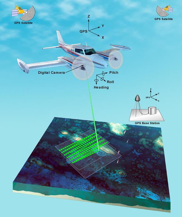
Illustration of airborne lidar acquisition platform
Airborne lidar is a surveying method that measures distance to a target from a survey plane by illuminating that target with a pulsed laser light, and measuring the reflected pulses with a sensor. Differences in laser return times and wavelengths can then be used to make digital 3D-representations of the target.
Airborne lidar is a surveying method that measures distance to a target from a survey plane by illuminating that target with a pulsed laser light, and measuring the reflected pulses with a sensor. Differences in laser return times and wavelengths can then be used to make digital 3D-representations of the target.

Lidar plane
Airborne lidar is a surveying method that measures distance to a target from a survey plane by illuminating that target with a pulsed laser light, and measuring the reflected pulses with a sensor. Differences in laser return times and wavelengths can then be used to make digital 3D-representations of the target.
Airborne lidar is a surveying method that measures distance to a target from a survey plane by illuminating that target with a pulsed laser light, and measuring the reflected pulses with a sensor. Differences in laser return times and wavelengths can then be used to make digital 3D-representations of the target.

Map of study areas in Sonoma and Mendocino Counties.
Map of study areas and key geographic features in Sonoma and Mendocino Counties.
Map of study areas and key geographic features in Sonoma and Mendocino Counties.

Moon Over Bosque Del Apache National Wildlife Refuge
Scenic view of the moon over Bosque Del Apache National Wildlife Refuge.
Scenic view of the moon over Bosque Del Apache National Wildlife Refuge.

Northeast crater wall above Sugar Bowl, Mount St. Helens with annot...
Northeast crater wall above Sugar Bowl, Mount St. Helens with annotated deposits from some of the Spirit Lake Stage eruptive periods. Photograph from late summer 2003.
Northeast crater wall above Sugar Bowl, Mount St. Helens with annotated deposits from some of the Spirit Lake Stage eruptive periods. Photograph from late summer 2003.

Northern Pintail (Anas acuta)
Northern Pintail walking on the ground.
Northern Pintail walking on the ground.

Potential Pathways for Veterinary Medicines in Soil and Water
Potential pathways for veterinary medicines in soil and water
Potential pathways for veterinary medicines in soil and water

Resurrection Bay multibeam imagery
Sonar-generated image showing underwater topography and the potential for landslides near the head of Resurrection Bay, Alaska. The terrain looks three times as steep as it occurs naturally. The arrow points to underwater landslide debris from the collapse of a fan-delta following the great Alaskan earthquake of 1964.
Sonar-generated image showing underwater topography and the potential for landslides near the head of Resurrection Bay, Alaska. The terrain looks three times as steep as it occurs naturally. The arrow points to underwater landslide debris from the collapse of a fan-delta following the great Alaskan earthquake of 1964.

Sandhill Crane (Grus canadensis)
Sandhill crane grazing in a grass field.
Sandhill crane grazing in a grass field.

Sandhill Crane (Grus canadensis)
Sandhill crane standing on the ground.
Sandhill crane standing on the ground.

Sandhill Crane (Grus canadensis)
Sandhill crane standing on the ground.
Sandhill crane standing on the ground.