
Eruptions in the Cascade Range during the past 4000 years. USGS GIP 64
Images
Volcano Hazard Program images.
Filter Total Items: 6226

Eruptions in the Cascade Range during the past 4000 years. USGS GIP 64
Eruptions in the Cascade Range during the past 4000 years. USGS GIP 64

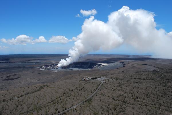
Vog obscures view during slack or no tradewinds at summit of Kīlauea
Vog obscures view during slack or no tradewinds at the summit of Kīlauea Volcano, Hawai‘i
Vog obscures view during slack or no tradewinds at the summit of Kīlauea Volcano, Hawai‘i

Installing geophysical boreholes in Yellowstone
UNAVCO engineers drilling a borehole for instrument installation (left). Aerial view of borehole casing used to protect instruments from the elements found below the surface (right).
UNAVCO engineers drilling a borehole for instrument installation (left). Aerial view of borehole casing used to protect instruments from the elements found below the surface (right).

Geologist on rim of Halema‘uma‘u downloading camera images, Kīlauea...
HVO geologist downloads images collected with infrared cameras set up on the rim of Halema‘uma‘u Crater. The cameras are aimed at an erupting lava lake to conduct a thermal survey of the lake's surface.
HVO geologist downloads images collected with infrared cameras set up on the rim of Halema‘uma‘u Crater. The cameras are aimed at an erupting lava lake to conduct a thermal survey of the lake's surface.

Seismologist installing equipment at station NED on Mount St. Helen...
Seismologist installing equipment at station NED on Mount St. Helens, Washington. Mount Rainier in distance.
Seismologist installing equipment at station NED on Mount St. Helens, Washington. Mount Rainier in distance.

Gas flux measurement taken over altered ground at Brimstone Basin
Gas flux measurement being taken over altered ground at Brimstone Basin, Yellowstone.
Gas flux measurement being taken over altered ground at Brimstone Basin, Yellowstone.

Gas flows up, appearing to boil, through the water of Alluvium Cree...
Gas flows up, appearing to boil, through the water of Alluvium Creek, Brimstone Basin, Yellowstone. Large funnel is used to trap gas, which is then sent to a collection bottle through the tubing.
Gas flows up, appearing to boil, through the water of Alluvium Creek, Brimstone Basin, Yellowstone. Large funnel is used to trap gas, which is then sent to a collection bottle through the tubing.

Sulfur flow (darker gray area) on an altered ground surface at Brim...
Sulfur flow (darker gray area) on an altered ground surface at Brimstone Basin, Yellowstone Lake in background.
Sulfur flow (darker gray area) on an altered ground surface at Brimstone Basin, Yellowstone Lake in background.

USGS HVO, Kīlauea, Hawaii
The Hawaiian Volcano Observatory perched on the west rim of Kīlauea Volcano's summit caldera, overlooks Halema‘uma‘u Crater, where a new vent that opened in March 2008 emits a volcanic gas plume.
The Hawaiian Volcano Observatory perched on the west rim of Kīlauea Volcano's summit caldera, overlooks Halema‘uma‘u Crater, where a new vent that opened in March 2008 emits a volcanic gas plume.

HVO on rim of Kīlauea's summit caldera overlooking Halema‘uma‘u, Ha...
The Hawaiian Volcano Observatory, the first volcano observatory in the United States, is located on the west rim of Kīlauea Volcano's summit caldera in Hawai‘i Volcanoes National Park. A volcanic gas plume rises from a vent that opened in 2008 at the base of the south wall of Halema‘uma‘u Crater. Crater Rim Drive in foreground.
The Hawaiian Volcano Observatory, the first volcano observatory in the United States, is located on the west rim of Kīlauea Volcano's summit caldera in Hawai‘i Volcanoes National Park. A volcanic gas plume rises from a vent that opened in 2008 at the base of the south wall of Halema‘uma‘u Crater. Crater Rim Drive in foreground.

HVO on rim of Kīlauea's summit caldera overlooking Halema‘uma‘u, Ha...
The U.S. Geological Survey's Hawaiian Volcano Observatory, the first volcano observatory in the United States, is located on the west rim of Kīlauea Volcano's summit caldera in Hawai‘i Volcanoes National Park. A volcanic gas plume rises from a vent that opened in 2008 at the base of the south wall of Halema‘uma‘u Crater. Crater Rim Drive in foreground.
The U.S. Geological Survey's Hawaiian Volcano Observatory, the first volcano observatory in the United States, is located on the west rim of Kīlauea Volcano's summit caldera in Hawai‘i Volcanoes National Park. A volcanic gas plume rises from a vent that opened in 2008 at the base of the south wall of Halema‘uma‘u Crater. Crater Rim Drive in foreground.

Volcanic-gas plumes emitted by ocean entry, Pu‘u ‘Ō‘ō vent, and Hal...
Volcanic-gas plumes mark the sites where lava flows from Pu‘u ‘Ō‘ō enter the ocean on Kīlauea's south coast (far left), the Pu‘u ‘Ō‘ō cone (left) on the East Rift Zone, and Halema‘uma‘u Crater at the summit (right). Structures visible in middle left primarily located around the Volcano Golf and Country Club and Kīlauea Military Camp.
Volcanic-gas plumes mark the sites where lava flows from Pu‘u ‘Ō‘ō enter the ocean on Kīlauea's south coast (far left), the Pu‘u ‘Ō‘ō cone (left) on the East Rift Zone, and Halema‘uma‘u Crater at the summit (right). Structures visible in middle left primarily located around the Volcano Golf and Country Club and Kīlauea Military Camp.

USGS Hawaiian Volcano Observatory Monitors Kilauea's Summit Eruption
The USGS Hawaiian Volcano Observatory (foreground) is located on the caldera rim of Kilauea Volcano, Hawai'i—the most active volcano in the world. The observatory's location provides an excellent view of summit eruptive activity, which began in 2008.
The USGS Hawaiian Volcano Observatory (foreground) is located on the caldera rim of Kilauea Volcano, Hawai'i—the most active volcano in the world. The observatory's location provides an excellent view of summit eruptive activity, which began in 2008.
The USGS Hawaiian Volcano Observatory Monitors Kilauea's Summit Eruption
The USGS Hawaiian Volcano Observatory (foreground) is located on the caldera rim of Kilauea Volcano, Hawai'ithe most active volcano in the world. The observatory's location provides an excellent view of summit eruptive activity, which began in 2008.
The USGS Hawaiian Volcano Observatory (foreground) is located on the caldera rim of Kilauea Volcano, Hawai'ithe most active volcano in the world. The observatory's location provides an excellent view of summit eruptive activity, which began in 2008.

Hawaiian Volcano Observatory field geologists track activity at fissure 8 (pictu
Hawaiian Volcano Observatory field geologists track activity at fissure 8 (pictured in the background). Crews collect fissure 8 tephra (Pele's hair, pumice, and other lightweight volcanic glass fragments) for geochemical analyses and characterization of changes in lava fountain behavior.
Hawaiian Volcano Observatory field geologists track activity at fissure 8 (pictured in the background). Crews collect fissure 8 tephra (Pele's hair, pumice, and other lightweight volcanic glass fragments) for geochemical analyses and characterization of changes in lava fountain behavior.

Lidar instrument uses light pulses to measure distances to ground s...
Lidar instrument uses light pulses to measure distances to the ground surface in the Kīlauea Caldera, Hawaii. Measurements are used to make a Digital Elevation Model - a very accurate topographic map.
Lidar instrument uses light pulses to measure distances to the ground surface in the Kīlauea Caldera, Hawaii. Measurements are used to make a Digital Elevation Model - a very accurate topographic map.

Narrow Gauge spring, Mammoth Hot Springs, Yellowstone National Park
Narrow Gauge spring, Mammoth Hot Springs, Yellowstone National Park. Vent area is between the two trees on top of the travertine deposits. Terraced pools form due to deposition of travertine from the fluids as they cool and degas carbon dioxide.
Narrow Gauge spring, Mammoth Hot Springs, Yellowstone National Park. Vent area is between the two trees on top of the travertine deposits. Terraced pools form due to deposition of travertine from the fluids as they cool and degas carbon dioxide.

Nighttime view of tephra-jet explosion, Kīlauea, Hawai‘i
Incandescent arcs trace the path of lava fragments cast out during a tephra-jet explosion at the Waikupanaha ocean entry in 2008. This is a relatively small explosion, reaching a few tens of meters (yards) height, while one earlier in the day was nearly 70 meters (230 ft) in height.
Incandescent arcs trace the path of lava fragments cast out during a tephra-jet explosion at the Waikupanaha ocean entry in 2008. This is a relatively small explosion, reaching a few tens of meters (yards) height, while one earlier in the day was nearly 70 meters (230 ft) in height.

Littoral Explosion At Kilauea Volcano, Hawai'i
When lava from the Pu'u 'Ō'ō-Kupaianaha eruption, active since 1983, meets the ocean, large littoral explosions can result.
When lava from the Pu'u 'Ō'ō-Kupaianaha eruption, active since 1983, meets the ocean, large littoral explosions can result.

Crater Lake Caldera with Wizard Island cinder cone and lava flows, ...
Crater Lake Caldera with Wizard Island cinder cone and lava flows, some of the youngest features in the caldera as seen from Merriam Point. Viewed toward the south. Oregon
Crater Lake Caldera with Wizard Island cinder cone and lava flows, some of the youngest features in the caldera as seen from Merriam Point. Viewed toward the south. Oregon

Fissure 8 continues to send lava to the sea
The early morning helicopter overflight of the lower East Rift Zone shows lava continuing to enter the sea at Ahalanui. The southern margin of the flow remains about a quarter mile from the boat ramp at Isaac Hale Park (jetty visible in the center left of the photo). View to the northeast.
The early morning helicopter overflight of the lower East Rift Zone shows lava continuing to enter the sea at Ahalanui. The southern margin of the flow remains about a quarter mile from the boat ramp at Isaac Hale Park (jetty visible in the center left of the photo). View to the northeast.