
View the annotated image.
Images
Volcano Hazard Program images.
Filter Total Items: 6226

Mount St. Helens crater July 26, 2006, nearly vertical view from SW.

Mount St. Helens Panorama
View northward from Mount St. Helens' crater rim, July 2006.
View northward from Mount St. Helens' crater rim, July 2006.

Excelsior Geyser and Grand Prismatic Spring, Yellowstone
Aerial view of Excelsior Geyser (in the foreground) and Grand Prismatic Spring in Yellowstone’s Midway Geyser Basin. The colors around the thermal features are locations of different thermophile communities. These thermophiles fix carbon, both from the atmosphere and from the hot water. Credit Jim Peaco; June 22, 2006; Catalog #20386d; Original #IT8M4075
Aerial view of Excelsior Geyser (in the foreground) and Grand Prismatic Spring in Yellowstone’s Midway Geyser Basin. The colors around the thermal features are locations of different thermophile communities. These thermophiles fix carbon, both from the atmosphere and from the hot water. Credit Jim Peaco; June 22, 2006; Catalog #20386d; Original #IT8M4075

San Francisco Volcanic Field Oct 12, 2003 ASTER satellite image dr...
San Francisco Volcanic Field Oct 12, 2003 ASTER satellite image draped over USGS topographic data. San Francisco Mountain upper center-right, volcanic field cinder cones and lava flows in foreground.
San Francisco Volcanic Field Oct 12, 2003 ASTER satellite image draped over USGS topographic data. San Francisco Mountain upper center-right, volcanic field cinder cones and lava flows in foreground.

Large cracks in active lava delta, Kīlauea
Substantial cracks cutting across a lava delta are clear indication that the delta is subsiding as it grows across the unstable pile of interfingering lava flows and fragments built on the steep submarine slope. The larger cracks on this delta are 1-2 m (3-6 ft) wide.
Substantial cracks cutting across a lava delta are clear indication that the delta is subsiding as it grows across the unstable pile of interfingering lava flows and fragments built on the steep submarine slope. The larger cracks on this delta are 1-2 m (3-6 ft) wide.

Active lava delta on SE coast of Kīlauea, Hawai‘i
Lava delta at East Lae‘apuki on the southeast coast of Kīlauea Volcano is about 17 hectares (43 acres). The delta extends about 400 m seaward from the sea cliff and is about 850 m long parallel to the shoreline. The steep sea cliff embayment resulted from collapses of earlier deltas; the collapses undermined and took away parts of the cliff.
Lava delta at East Lae‘apuki on the southeast coast of Kīlauea Volcano is about 17 hectares (43 acres). The delta extends about 400 m seaward from the sea cliff and is about 850 m long parallel to the shoreline. The steep sea cliff embayment resulted from collapses of earlier deltas; the collapses undermined and took away parts of the cliff.

Helicopter flying toward lava spine at Mount St. Helens to collect ...
Helicopter flying toward lava spine at Mount St. Helens to collect rocks—note the "Jaws" collector hanging underneath. April 28, 2007
Helicopter flying toward lava spine at Mount St. Helens to collect rocks—note the "Jaws" collector hanging underneath. April 28, 2007

Old Faithful in eruption
Old Faithful Geyser in eruption. Under Yellowstone Research Permit YELL-SCI-8030, 13 mineralized wood specimens were collected from the geyser mound. The dates of the mineralized wood samples imply that such eruptions did not take place for over a century between the mid-13th to mid-14th centuries.
Old Faithful Geyser in eruption. Under Yellowstone Research Permit YELL-SCI-8030, 13 mineralized wood specimens were collected from the geyser mound. The dates of the mineralized wood samples imply that such eruptions did not take place for over a century between the mid-13th to mid-14th centuries.

US Army helicopter flies over the heads of researchers on Mauna Kea
A US Army helicopter from Pohakuloa Training Area flies overhead of palila researchers on Mauna Kea volcano, Hawai‘i Island, Hawai‘i.
A US Army helicopter from Pohakuloa Training Area flies overhead of palila researchers on Mauna Kea volcano, Hawai‘i Island, Hawai‘i.

Glacier Peak, northern WA
Glacier Peak is the tallest peak amongst a sea of many mountains in northern Washington.
Glacier Peak is the tallest peak amongst a sea of many mountains in northern Washington.

Upper west face of Glacier Peak, WA.
Upper west face of Glacier Peak, Washington.
Upper west face of Glacier Peak, Washington.

Scanning Electron Microscope (SEM)
SEM (Scanning electron Microscope) image of a vesicular ash particle erupted by Augustine volcano on January 13, 2006. The ash sample was collected during the ashfall in Homer, Alaska by John Paskievitch, AVO.
SEM (Scanning electron Microscope) image of a vesicular ash particle erupted by Augustine volcano on January 13, 2006. The ash sample was collected during the ashfall in Homer, Alaska by John Paskievitch, AVO.

Kīlauea East Rift Zone lava flows and fissures, July 11, 1:00 p.m. HST
Map as of 1:00 p.m. HST, July 11, 2018. Given the dynamic nature of Kīlauea's lower East Rift Zone eruption, with changing vent locations, fissures starting and stopping, and varying rates of lava effusion, map details shown here are accurate as of the date/time noted. Shaded purple areas indicate lava flows erupted in 1840, 1955, 1960, and 2014-2015.
Map as of 1:00 p.m. HST, July 11, 2018. Given the dynamic nature of Kīlauea's lower East Rift Zone eruption, with changing vent locations, fissures starting and stopping, and varying rates of lava effusion, map details shown here are accurate as of the date/time noted. Shaded purple areas indicate lava flows erupted in 1840, 1955, 1960, and 2014-2015.

Kīlauea lower East Rift Zone lava
Helicopter overflight photo taken this morning - view toward the west directly above Kapoho Crater. The fissure 8 lava channel now bends sharply to the south on the western edge of the crater after being blocked and diverted yesterday.
Helicopter overflight photo taken this morning - view toward the west directly above Kapoho Crater. The fissure 8 lava channel now bends sharply to the south on the western edge of the crater after being blocked and diverted yesterday.

Crater Lake is the remnant of Mount Mazama, which erupted catastrop...
Crater Lake is the remnant of Mount Mazama, which erupted catastrophically 7,700 years ago to form the caldera.Wizard Island in lake and Mount Scott is peak on right shore. View from south. Oregon
Crater Lake is the remnant of Mount Mazama, which erupted catastrophically 7,700 years ago to form the caldera.Wizard Island in lake and Mount Scott is peak on right shore. View from south. Oregon

Julie Donnelly-Nolan taking notes while working in the field.
Julie Donnelly-Nolan taking notes while working in the field at Newberry Volcano.
Julie Donnelly-Nolan taking notes while working in the field at Newberry Volcano.

Topographic map, Mount St. Helens, C.E. 1919 annotated with locatio...
Due to the cataclysmic eruption of May 18, 1980, many of the locations annotated on this map are now either covered or no longer visible.
Due to the cataclysmic eruption of May 18, 1980, many of the locations annotated on this map are now either covered or no longer visible.
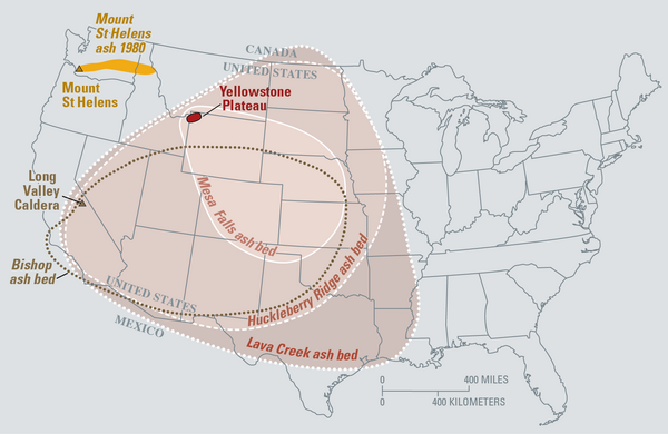
Map of the known ash-fall boundaries for several U.S. eruptions
Eruptions of the Yellowstone volcanic system have included the two largest volcanic eruptions in North America in the past few million years; the third largest was at Long Valley in California and produced the Bishop ash bed. The biggest of the Yellowstone eruptions occurred 2.1 million years ago, depositing the Huckleberry Ridge ash bed.
Eruptions of the Yellowstone volcanic system have included the two largest volcanic eruptions in North America in the past few million years; the third largest was at Long Valley in California and produced the Bishop ash bed. The biggest of the Yellowstone eruptions occurred 2.1 million years ago, depositing the Huckleberry Ridge ash bed.

Vents and lava flows from the Kīlauea eruption of 1955
This 88 day eruption spawned lava flows which crossed all major roads to lower Puna. Coastal villages from Kalapana to Kapoho were isolated. Major roads closed by lava included Pahoa-Pohoiki; Pahoa-Kapoho; Pahoa-Opihikao; and Pahoa-Kalapana as well as the lower Puna coastal highway.
This 88 day eruption spawned lava flows which crossed all major roads to lower Puna. Coastal villages from Kalapana to Kapoho were isolated. Major roads closed by lava included Pahoa-Pohoiki; Pahoa-Kapoho; Pahoa-Opihikao; and Pahoa-Kalapana as well as the lower Puna coastal highway.

USGS Debris-flow flume near Blue River, OR is used to conduct debris flow and landslide experiments.
linkUSGS Debris-flow flume near Blue River, Oregon is used to conduct debris flows and landslide experiments. Flume is a reinforced concrete channel 95 m (310 ft long, 2 m (6.6 ft) wide, and 1.2 m (4 ft).

Crater Lake from the air viewed from SW. Wizard Island is the coni...
Crater Lake from the air viewed from the southwest. Wizard Island is the conical mound in the lake and Mount Scott is the peak beyond the lake. Oregon
Crater Lake from the air viewed from the southwest. Wizard Island is the conical mound in the lake and Mount Scott is the peak beyond the lake. Oregon