
Volcanic gases react with the atmosphere in various ways; the conversion of sulfur dioxide (SO2) to sulfuric acid (H2SO4) has the most significant impact on climate.
Images
Volcano Hazard Program images.
Filter Total Items: 6226

Volcanic gases react with the atmosphere in various ways
Volcanic gases react with the atmosphere in various ways; the conversion of sulfur dioxide (SO2) to sulfuric acid (H2SO4) has the most significant impact on climate.

Vog conditions on the Island of Hawai‘i vary depending on wind direction
During prevailing trade wind conditions, the nearly constant stream of volcanic smog (vog) produced by Kīlauea Volcano on the Island of Hawai‘i is blown to the southwest and west. The trade winds (blue arrows) blow the vog from its main source on the volcano (white plume) to the southwest, where wind patterns send it up the island's Kona coast.
During prevailing trade wind conditions, the nearly constant stream of volcanic smog (vog) produced by Kīlauea Volcano on the Island of Hawai‘i is blown to the southwest and west. The trade winds (blue arrows) blow the vog from its main source on the volcano (white plume) to the southwest, where wind patterns send it up the island's Kona coast.
Geologic map of Mauna Kea with generalized surface distribution of ...
Geologic map of Mauna Kea with generalized surface distribution of Hamakua Volcanics. Laupahoehoe Volcanics are inferred to overlie a vast area of Hamakua Volcanics on the upper flanks and summit.
Geologic map of Mauna Kea with generalized surface distribution of Hamakua Volcanics. Laupahoehoe Volcanics are inferred to overlie a vast area of Hamakua Volcanics on the upper flanks and summit.

Geologic map of Mauna Kea, showing generalized distribution of lava...
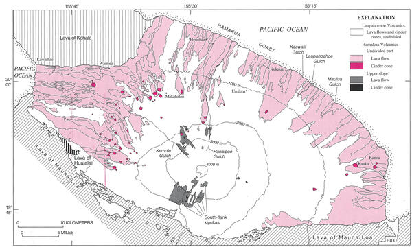
Geologic map of Mauna Kea, showing generalized distribution of lava flows, cinder cones, and glacial deposits of the Laupahoehoe Volcanics.
Geologic map of Mauna Kea, showing generalized distribution of lava flows, cinder cones, and glacial deposits of the Laupahoehoe Volcanics.

View of the Mono Lake-Long Valley volcanic region
An aerial view looking south of the Long Valley volcanic region in the area of Mono Lake, showing a line of rhyolite lava domes and explosion craters. An inset map shows the locations of silcic magmatic centers in the Long Valley area.
An aerial view looking south of the Long Valley volcanic region in the area of Mono Lake, showing a line of rhyolite lava domes and explosion craters. An inset map shows the locations of silcic magmatic centers in the Long Valley area.

Profile of Mauna Kea showing inferred contact (dot-dashed line) bet...
Profile of Mauna Kea showing inferred contact (dot-dashed line) between postshield-stage Hamakua Volcanics and underlying shield-stage lavas. Approximate contact with Laupahoehoe Volcanics dashed.
Profile of Mauna Kea showing inferred contact (dot-dashed line) between postshield-stage Hamakua Volcanics and underlying shield-stage lavas. Approximate contact with Laupahoehoe Volcanics dashed.

Rock and ice debris (Oct. 20, 1997) on east side of Mount Adams
Rock and ice debris avalanche (October 20, 1997) on the east side of Mount Adams.
Rock and ice debris avalanche (October 20, 1997) on the east side of Mount Adams.

Coso Volcanic Field Tumulus
A tumulus in the Coso Volcanic Field, California. This lava was probably more viscous than the lava found in the Hawaii tumuli.
A tumulus in the Coso Volcanic Field, California. This lava was probably more viscous than the lava found in the Hawaii tumuli.

A'a' Channel
Detail of levee on an active channelized aa flow. Note the pahoehoe overflows in the levees and the level of the active flow below the tops of the levees. This lower flow level is not allowed in the commonly used "Bingham" model of lava flows.
Detail of levee on an active channelized aa flow. Note the pahoehoe overflows in the levees and the level of the active flow below the tops of the levees. This lower flow level is not allowed in the commonly used "Bingham" model of lava flows.

Mount Konocti, a 1,312 m (4,305 ft) mountain on the eastern shore o...
Mt. Konocti erupted during the most recent stage of volcanism (01. Ma to 10,000 years ago), and a future eruption from the same site would be devastating to the nearby inhabitants.
Mt. Konocti erupted during the most recent stage of volcanism (01. Ma to 10,000 years ago), and a future eruption from the same site would be devastating to the nearby inhabitants.

Vatnajökull Jökulhlaup
Photograph of the large jökulhlaup that spread out across Skeiðarársandur (glacial outwash plain) from the terminus of Skeiðarárjökull, an outlet glacier of Vatnajökull.
Photograph of the large jökulhlaup that spread out across Skeiðarársandur (glacial outwash plain) from the terminus of Skeiðarárjökull, an outlet glacier of Vatnajökull.

Tephra-jet explosion hurls spatter 50 m (165 ft) high to create a l...
Lava fragments explode onto the sides of a littoral cone on the south coast of Kīlauea Volcano as lava pours into the sea from a lava tube.
Lava fragments explode onto the sides of a littoral cone on the south coast of Kīlauea Volcano as lava pours into the sea from a lava tube.

Mount Konocti viewed from Cinder Cone, Clear Lake Volcanic Field.
Mount Konocti, the most distinct volcanic feature of the Clear Lake Volcanics as viewed to the west from Cinder Cone.
Mount Konocti, the most distinct volcanic feature of the Clear Lake Volcanics as viewed to the west from Cinder Cone.

Lahars pick up material as they travel, which can cause damage to s...
Lahars pick up material as they travel, which can cause damage to structures in their path. Damage here from Mt. Pinatubo, Philippines.
Lahars pick up material as they travel, which can cause damage to structures in their path. Damage here from Mt. Pinatubo, Philippines.

Queen's Laundry bathhouse, in Yellowstone's Lower Geyser Basin
Queen's Laundry bathhouse, in the Lower Geyser Basin of Yellowstone National Park. Building began under superintendent Philetus Norris in 1881 but was never finished.
Queen's Laundry bathhouse, in the Lower Geyser Basin of Yellowstone National Park. Building began under superintendent Philetus Norris in 1881 but was never finished.

Lassen Peak's Devastated Area photographed from the air in 1994.
Lassen Peak's Devastated Area photographed from the air in 1994.
Lassen Peak's Devastated Area photographed from the air in 1994.

Lava bubble burst explosion on active lava delta, Kīlauea, Hawai‘i
Two bubble bursts explode simultaneously as a consequence seawater mixing with lava in a lava tube beneath surface of a lava delta. Because of the confined conditions in the lava tube, explosive pressures build up as water, heated by contact with molten lava, expands instantly to steam.
Two bubble bursts explode simultaneously as a consequence seawater mixing with lava in a lava tube beneath surface of a lava delta. Because of the confined conditions in the lava tube, explosive pressures build up as water, heated by contact with molten lava, expands instantly to steam.

Hummocks on West Island, AK, 8 km (5 mi) WNW from Aug.ine Volcano s...
Hummocks on West Island, Alaska, 8 km (5 mi) WNW from Augustine Volcano summit. These small hills were deposited as part of the 1883 debris avalanche (landslide) that triggered a Cook Inlet tsunami.
Hummocks on West Island, Alaska, 8 km (5 mi) WNW from Augustine Volcano summit. These small hills were deposited as part of the 1883 debris avalanche (landslide) that triggered a Cook Inlet tsunami.

Mt. Spurr, Crater Peak
Roiling eruption column rising from Crater Peak vent of Mt. Spurr volcano. View from the south.
Roiling eruption column rising from Crater Peak vent of Mt. Spurr volcano. View from the south.

Finding the Fumarole Vent
USGS hydrologist Michael Sorey tries to locate the steam vent at a fumarole in the Bumpass Hell area in Lassen Volcanic National Park.
USGS hydrologist Michael Sorey tries to locate the steam vent at a fumarole in the Bumpass Hell area in Lassen Volcanic National Park.

Steamboat Geyser in the steam-phase of an eruption on June 4, 2018, Norris Geyse
Steamboat Geyser in the steam-phase of an eruption on June 4, 2018, Norris Geyser Basin, Yellowstone National Park. Photo by Jamie Farrell (University of Utah).
Steamboat Geyser in the steam-phase of an eruption on June 4, 2018, Norris Geyser Basin, Yellowstone National Park. Photo by Jamie Farrell (University of Utah).