
Dann Blackwood and Jon Borden inspect a current meter retrieved from the ocean using the research boat Muddy Waters near Wellfleet, Massachusetts.
Images
Images intro.
Filter Total Items: 2135

Dann Blackwood and Jon Borden inspect a retrieved current meter
Dann Blackwood and Jon Borden inspect a current meter retrieved from the ocean using the research boat Muddy Waters near Wellfleet, Massachusetts.

Nor'Easter impacts in Sandwich
The house with the USGS BeachCam is in the center of this image, taken Feb. 14, 2017 after a much smaller Noreaster. Visible in the foreground on the left are the remnants of the artificial dune (completely removed by the March 2018 storm), and on the right is the engineered protection put in place by private property owners.
The house with the USGS BeachCam is in the center of this image, taken Feb. 14, 2017 after a much smaller Noreaster. Visible in the foreground on the left are the remnants of the artificial dune (completely removed by the March 2018 storm), and on the right is the engineered protection put in place by private property owners.

Armoring the shore at Goleta Beach
Installing large boulders as rip rap to armor the shore against further erosion at Goleta Beach in Southern California. The tide is very low (negative).
Installing large boulders as rip rap to armor the shore against further erosion at Goleta Beach in Southern California. The tide is very low (negative).

Exposed bedrock at low tide
Exposed bedrock on the beach, below the University of California, Santa Barbara.
Exposed bedrock on the beach, below the University of California, Santa Barbara.

Beach loss and armoring at Goleta Beach
Beach loss and armoring at Goleta Beach, very low (negative) tide
Beach loss and armoring at Goleta Beach, very low (negative) tide

Exposed bedrock at Isla Vista beach
Bedrock exposed at low tide along the beach at Isla Vista, California
Bedrock exposed at low tide along the beach at Isla Vista, California

Exposed bedrock at Isla Vista
Exposed bedrock on the beach during very low (negative) tide at Isla Vista, California
Exposed bedrock on the beach during very low (negative) tide at Isla Vista, California

Net Sedimentation Tile (NST)
A net sedimentation tile (NST) is used by scientists to measure surface sediment deposition in wetlands over short time scales. Scientists installed several NSTs on the surface of the marsh to measure sediment deposition. The samples are retrieved and measured in the lab to identify short-term sediment deposition rates on the marsh surface.
A net sedimentation tile (NST) is used by scientists to measure surface sediment deposition in wetlands over short time scales. Scientists installed several NSTs on the surface of the marsh to measure sediment deposition. The samples are retrieved and measured in the lab to identify short-term sediment deposition rates on the marsh surface.

USGS researcher uses GPS-equipped backpack to measure sand elevations
USGS oceanographer Dan Hoover uses a GPS-equipped backpack to measure sand elevations near the mouth of the San Lorenzo River in Santa Cruz, California, January 12, 2017. Surveys like this make long-term studies of coastal change possible.
USGS oceanographer Dan Hoover uses a GPS-equipped backpack to measure sand elevations near the mouth of the San Lorenzo River in Santa Cruz, California, January 12, 2017. Surveys like this make long-term studies of coastal change possible.

Atmospheric River Fills California Rivers with Water and Sediment
An atmospheric river, or narrow band of moisture moving from the tropics to the higher latitudes, hit California in early January and brought the first heavy rains of 2017. While these storms help a drought-stricken state, the onslaught of rain triggers floods and mudslides, and fills rising rivers with sediment and debris.
An atmospheric river, or narrow band of moisture moving from the tropics to the higher latitudes, hit California in early January and brought the first heavy rains of 2017. While these storms help a drought-stricken state, the onslaught of rain triggers floods and mudslides, and fills rising rivers with sediment and debris.

Readying a sonar-equipped boat for mapping
USGS scientists readying a sonar-equipped boat to map the ocean bottom near Santa Cruz, Calif.
USGS scientists readying a sonar-equipped boat to map the ocean bottom near Santa Cruz, Calif.

Sonar-equipped personal watercraft mapping bathymetry.
A sonar-equipped personal watercraft mapping the bathymetry underwater near Santa Cruz, Calif.
A sonar-equipped personal watercraft mapping the bathymetry underwater near Santa Cruz, Calif.

Mapping the beach with a GPS-equipped backpack unit.
USGS scientist Daniel Hoover mapping the beach at Santa Cruz with a GPS-equipped backpack unit.
USGS scientist Daniel Hoover mapping the beach at Santa Cruz with a GPS-equipped backpack unit.

Setting up a lidar scanner to map the beach.
USGS scientists setting up a lidar scanner on the pier to map the beach near Capitola, California.
USGS scientists setting up a lidar scanner on the pier to map the beach near Capitola, California.

Map of seabed geology and sun-illuminated topography, Stellwagen Bank
Map of seabed geology and sun-illuminated topography, Stellwagen Bank Blue and purple = boulder ridges. Redlines = leading edges of sand sheets
Map of seabed geology and sun-illuminated topography, Stellwagen Bank Blue and purple = boulder ridges. Redlines = leading edges of sand sheets

Humpback whale breaching
A humpback whale breaches the surface of the ocean near a coastline. Humpback whales migrate towards warmer waters during the cold winter months.
A humpback whale breaches the surface of the ocean near a coastline. Humpback whales migrate towards warmer waters during the cold winter months.

Map of Panama and Pacific Coast
Map of Panama, with the Pacific Coast on the southern (lower) side. The Gulf of Panama is also shown to the southern side of Panama.
Map of Panama, with the Pacific Coast on the southern (lower) side. The Gulf of Panama is also shown to the southern side of Panama.

Coastal and Marine Geology Program team at the USGS awards ceremony
Coastal and Marine Geology Program web team members receive their awards at the USGS Awards Ceremony on May 3, 2016. From left to right: USGS Director Suzette Kimball, who presented the awards; Jolene Gittens; Greg Miller; Kerry Rae, Chief of Staff for Jennifer Gimbel, Deputy Assistant Secretary for Water and Science, U.S. Dept.
Coastal and Marine Geology Program web team members receive their awards at the USGS Awards Ceremony on May 3, 2016. From left to right: USGS Director Suzette Kimball, who presented the awards; Jolene Gittens; Greg Miller; Kerry Rae, Chief of Staff for Jennifer Gimbel, Deputy Assistant Secretary for Water and Science, U.S. Dept.
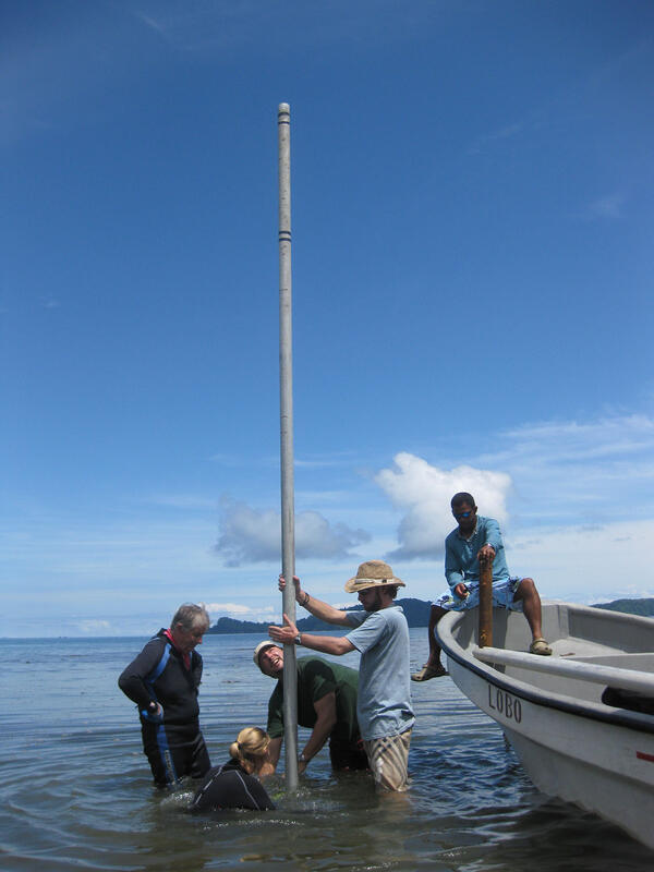
Taking a coral core in the Gulf of Chiriqui, Panama
Collecting a coral core in the Gulf of Chiriqui, Panama, by forcing a 20-foot aluminum tube into the reef. This core retrieved about 6,000 years of reef history.
Collecting a coral core in the Gulf of Chiriqui, Panama, by forcing a 20-foot aluminum tube into the reef. This core retrieved about 6,000 years of reef history.

Brain coral spawning coral larvae
Brain coral spawning coral larvae. The larvae will settle on other surfaces and grow into new coral in a process called recruitment.
Brain coral spawning coral larvae. The larvae will settle on other surfaces and grow into new coral in a process called recruitment.

Cinder block calcification station with live coral
A cinder block calcification monitoring station offshore Florida, with a live coral on top.
A cinder block calcification monitoring station offshore Florida, with a live coral on top.