
The presence of spherulites indicates that a lava flow cooled quickly, and their mineralogy holds clues to its precise cooling history. USGS photo by Jessica Ball
Images
Images related to Long Valley Caldera.

Large spherulites in Hot Creek rhyolite lava in the Long Valley Caldera
The presence of spherulites indicates that a lava flow cooled quickly, and their mineralogy holds clues to its precise cooling history. USGS photo by Jessica Ball

Panoramic view of the Long Valley Caldera from its north side
This panorama of the Long Valley Caldera, looking from north to south, shows its broad central plain, post-caldera rhyolite flows and uplift on the right, and eastern Sierra Nevada in the background. USGS photo by Jessica Ball.
This panorama of the Long Valley Caldera, looking from north to south, shows its broad central plain, post-caldera rhyolite flows and uplift on the right, and eastern Sierra Nevada in the background. USGS photo by Jessica Ball.

Eddy covariance station at Mammoth Mountain, California
Photograph of permanent eddy covariance station installed since 2014 in area of volcanic CO2 emissions on Mammoth Mountain, California. USGS photo by Jennifer Lewicki, August 2019.
Photograph of permanent eddy covariance station installed since 2014 in area of volcanic CO2 emissions on Mammoth Mountain, California. USGS photo by Jennifer Lewicki, August 2019.

Simplified geologic map (left) and diagrammatic cross section (right) of Long Valley Caldera.
Simplified geologic map (left) and diagrammatic cross section (right) of Long Valley Caldera. The resurgent dome, Doe Ridge, Mammoth Mountain, and the Inyo Craters and Domes all reflect volcanic activity since 760,000 years ago, when a giant eruption formed the caldera.
Simplified geologic map (left) and diagrammatic cross section (right) of Long Valley Caldera. The resurgent dome, Doe Ridge, Mammoth Mountain, and the Inyo Craters and Domes all reflect volcanic activity since 760,000 years ago, when a giant eruption formed the caldera.

Long Valley Caldera map
Map showing distribution of Long Valley postcaldera rhyolites. Abbreviations: CD, Casa Diablo geothermal plant; Ski area, Mammoth Mountain Ski Area; LVEW, Long Valley Exploratory Well, 3 km deep, located high on resurgent uplift; s, surficial deposits filling structural lows on resurgent uplift.
Map showing distribution of Long Valley postcaldera rhyolites. Abbreviations: CD, Casa Diablo geothermal plant; Ski area, Mammoth Mountain Ski Area; LVEW, Long Valley Exploratory Well, 3 km deep, located high on resurgent uplift; s, surficial deposits filling structural lows on resurgent uplift.

Flow banding of Panum pumice and obsidian
Flow banding of Panum pumice and obsidian of the same composition.
Flow banding of Panum pumice and obsidian of the same composition.

Model of reservoirs underneath Long Valley Caldera
Main hydrothermal features of the new (2016) 3-D model of the subsurface at Long Valley Caldera. This schematic is based on a survey of the electrical properties of the earth (magnetotellurics) below. Arrows show subsurface water flow, with colors keyed to changing water temperature, from blue (cold) to red (hot). Purple arrows show an extinct hot water pathway.
Main hydrothermal features of the new (2016) 3-D model of the subsurface at Long Valley Caldera. This schematic is based on a survey of the electrical properties of the earth (magnetotellurics) below. Arrows show subsurface water flow, with colors keyed to changing water temperature, from blue (cold) to red (hot). Purple arrows show an extinct hot water pathway.

Long Valley Caldera range-front faults terminate at the caldera bou...
This is a simplified diagram of regional range front faults as they intersect the Long Valley Caldera.
This is a simplified diagram of regional range front faults as they intersect the Long Valley Caldera.

Conceptual geologic model of partially crystallized magma (C1, C3) ...
C1 and C3 are granitic crystal-melt mush (partially crystallized magma) columns that fed the most recent Mono Craters eruptions. The connection from C1 to South Coulée (SC) is older and colder than the connection from C3 to North Coulée (NC) and Panum Crater (PC), which carries hydrothermal fluid to the surface.
C1 and C3 are granitic crystal-melt mush (partially crystallized magma) columns that fed the most recent Mono Craters eruptions. The connection from C1 to South Coulée (SC) is older and colder than the connection from C3 to North Coulée (NC) and Panum Crater (PC), which carries hydrothermal fluid to the surface.

Wes Hildreth at Long Valley Caldera
Wes Hildreth is an expert when it comes to studying the Long Valley Caldera. Here, he is standing on Tertiary basalt lava flows on the north rim of the caldera, view to the southeast with Lake Crowley visible in the center of the caldera, and McGee Mountain above the lake on the skyline.
Wes Hildreth is an expert when it comes to studying the Long Valley Caldera. Here, he is standing on Tertiary basalt lava flows on the north rim of the caldera, view to the southeast with Lake Crowley visible in the center of the caldera, and McGee Mountain above the lake on the skyline.
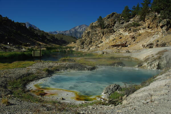
Bubbling Spring, a feature of Hot Creek in the Long Valley Caldera,...
Bubbling Spring, a feature of Hot Creek in the Long Valley Caldera, California, occasionally "boils" due to high water temperature.
Bubbling Spring, a feature of Hot Creek in the Long Valley Caldera, California, occasionally "boils" due to high water temperature.

Soil-temperature measurement at Hot Creek in Long Valley Caldera, CA.
Soil-temperature measurement at Hot Creek in Long Valley Caldera, California.
Soil-temperature measurement at Hot Creek in Long Valley Caldera, California.
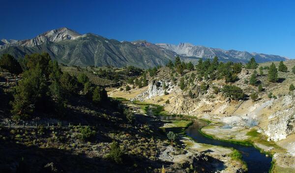
Hot Creek Gorge viewed upstream toward the SW; the steep walls of t...
Hot Creek Gorge viewed upstream toward the southwest; the steep walls of the gorge consist of a single rhyolite lava flow erupted from a vent 4 km (2.5 mi) to the south.
Hot Creek Gorge viewed upstream toward the southwest; the steep walls of the gorge consist of a single rhyolite lava flow erupted from a vent 4 km (2.5 mi) to the south.

Hydrothermal system and water flow in the subsurface beneath Long V...
Hydrothermal system and water flow in the subsurface beneath Long Valley Caldera, California. Cartoon Illustration from USGS FS 2007-3045.
Hydrothermal system and water flow in the subsurface beneath Long Valley Caldera, California. Cartoon Illustration from USGS FS 2007-3045.
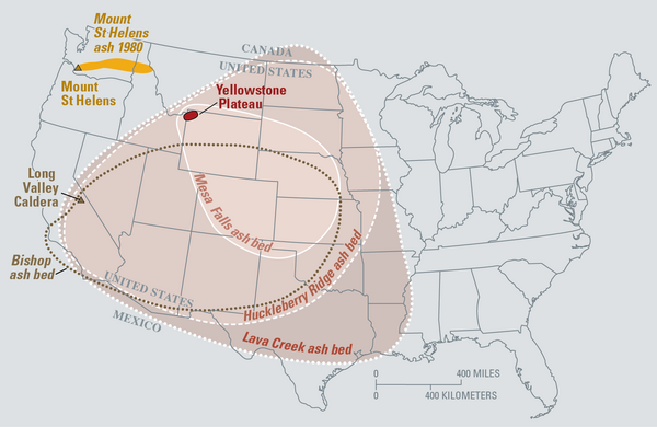
Map of the known ash-fall boundaries for several U.S. eruptions
Eruptions of the Yellowstone volcanic system have included the two largest volcanic eruptions in North America in the past few million years; the third largest was at Long Valley in California and produced the Bishop ash bed. The biggest of the Yellowstone eruptions occurred 2.1 million years ago, depositing the Huckleberry Ridge ash bed.
Eruptions of the Yellowstone volcanic system have included the two largest volcanic eruptions in North America in the past few million years; the third largest was at Long Valley in California and produced the Bishop ash bed. The biggest of the Yellowstone eruptions occurred 2.1 million years ago, depositing the Huckleberry Ridge ash bed.

USGS scientists measuring temperature in a deep borehole in the Long Valley Caldera
USGS scientists measuring temperature in a deep borehole in Long Valley Caldera with the Sierra Nevada mountains in the background.
USGS scientists measuring temperature in a deep borehole in Long Valley Caldera with the Sierra Nevada mountains in the background.

Map of volcanic ash fall as a result of eruptions from Yellowstone,...
Map of volcanic ashfall. Areas of the United States that once were covered by volcanic ash from Yellowstone's giant eruptions 2 million and 630,000 years ago, compared with ashfall from the 760,000-year-old Long Valley caldera eruptions at Mammoth Lakes, California, and the 1980 eruption of Mount St. Helens, Washington.
Map of volcanic ashfall. Areas of the United States that once were covered by volcanic ash from Yellowstone's giant eruptions 2 million and 630,000 years ago, compared with ashfall from the 760,000-year-old Long Valley caldera eruptions at Mammoth Lakes, California, and the 1980 eruption of Mount St. Helens, Washington.

View of the Mono Lake-Long Valley volcanic region
An aerial view looking south of the Long Valley volcanic region in the area of Mono Lake, showing a line of rhyolite lava domes and explosion craters. An inset map shows the locations of silcic magmatic centers in the Long Valley area.
An aerial view looking south of the Long Valley volcanic region in the area of Mono Lake, showing a line of rhyolite lava domes and explosion craters. An inset map shows the locations of silcic magmatic centers in the Long Valley area.